TopoQuest Logo
Do you find TopoQuest useful?
Help keep TopoQuest running and adding new maps/features by donating!
Bitcoin:  19c7KJd3qBynnjoSw5npx9KScwjBe4ifkT
Litecoin:  LXs6TkuXGGXo1vDsWCkWVdjQX94eUKd6ui
Home View Maps Find Maps Find Places Resources & Links


Buena, New Jersey Topographic Map

USGS Map Title: Buena, NJ
USGS Map MRC: 39074E8
DRG (GeoTIFF) Download: o39074e8.tif


Neighboring USGS Topographic Map Quads:


  Pitman East, NJ  
39075F1
 

  Williamstown, NJ  
39074F8
 

  Hammonton, NJ  
39074F7
 

  Newfield, NJ  
39075E1
 

  Buena, NJ  
39074E8
 

  Newtonville, NJ  
39074E7
 

  Millville, NJ  
39075D1
 

  Five Points, NJ  
39074D8
 

  Dorothy, NJ  
39074D7


Map MRC Location:

N40°
W75°
N40°
W74°
H8 H7 H6 H5 H4 H3 H2 H1
G8 G7 G6 G5 G4 G3 G2 G1
F8 F7 F6 F5 F4 F3 F2 F1
E8 E7 E6 E5 E4 E3 E2 E1
D8 D7 D6 D5 D4 D3 D2 D1
C8 C7 C6 C5 C4 C3 C2 C1
B8 B7 B6 B5 B4 B3 B2 B1
A8 A7 A6 A5 A4 A3 A2 A1
N39°
W75°
N39°
W74°

Buena, NJ USGS 1:24K Topographic Map Preview:
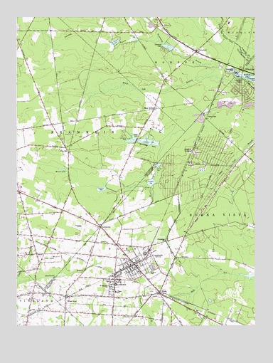
Buena, NJ USGS Topographic Map
Click on map above to begin viewing in our Map Viewer.

This topographic map contains these locations and features:
Feature Name Type Latitude Longitude GNIS ID View Map
Als Landing Strip (historical)AirportN39.5262°W74.9560°884830View Map
Bellone's NurseryBuildingN39.5422°W74.9689°2634357View Map
BerrylandPopulated PlaceN39.6112°W74.9057°874699View Map
Blue BellPopulated PlaceN39.5721°W74.9741°874825View Map
Borough of BuenaCivilN39.5282°W74.9448°885173View Map
Braddock LakeReservoirN39.6013°W74.8796°874882View Map
Braddock Lake DamDamN39.6004°W74.8782°883882View Map
Brimfield CrossingPopulated PlaceN39.5709°W74.9077°874945View Map
BuenaPopulated PlaceN39.5137°W74.9246°875018View Map
Buena Borough PoliceBuildingN39.5218°W74.9487°2730875View Map
Buena Regional High SchoolSchoolN39.5366°W74.9191°2333321View Map
Cains Mill LakeReservoirN39.6032°W74.8870°875082View Map
Cains Mill Pond DamDamN39.6007°W74.8821°883883View Map
Cedar LakePopulated PlaceN39.5837°W74.9002°875299View Map
Cedar LakeReservoirN39.5758°W74.9398°875301View Map
Cedar LakeReservoirN39.5835°W74.9047°883884View Map
Cedar Lake DamDamN39.5851°W74.9029°883885View Map
Cedar Lake DamDamN39.5751°W74.9368°883886View Map
Cleary SchoolSchoolN39.5137°W74.9477°875479View Map
Collings Lake Elementary SchoolSchoolN39.5874°W74.8811°2333305View Map
Collings Lake PitMineN39.5911°W74.8889°2678068View Map
Collings LakesPopulated PlaceN39.5957°W74.8816°875560View Map
Collings Lakes Census Designated PlaceCensusN39.5939°W74.8821°2389344View Map
Collings Lakes Volunteer Fire DepartmentBuildingN39.5905°W74.8812°2401854View Map
Cranes LakeReservoirN39.6217°W74.9302°883879View Map
Cranes Lake DamDamN39.6209°W74.9274°883880View Map
Diamond LakeReservoirN39.6136°W74.9218°875909View Map
Diamond Lake DamDamN39.6118°W74.9182°883881View Map
DownstownPopulated PlaceN39.5398°W74.9557°875960View Map
Faraway BranchStreamN39.6154°W74.9252°876299View Map
Forest GrovePopulated PlaceN39.5273°W74.9863°876405View Map
Forest Grove Volunteer Fire CompanyBuildingN39.5296°W74.9847°2401897View Map
Friendship ChurchChurchN39.5346°W74.9216°876528View Map
Hospitality LakeLakeN39.6032°W74.8870°877265View Map
John C Milanesi Elementary SchoolSchoolN39.5125°W74.9238°2333411View Map
Johnstone Elementary SchoolSchoolN39.5357°W74.9572°2333346View Map
Lake GeorgeReservoirN39.5851°W74.9029°884170View Map
Lake George DamDamN39.5851°W74.9029°884169View Map
LandisvillePopulated PlaceN39.5248°W74.9382°877664View Map
Landisville Volunteer Fire Company 1BuildingN39.5267°W74.9409°2401856View Map
Long BranchStreamN39.5179°W74.9982°877906View Map
Main Road Elementary SchoolSchoolN39.5563°W74.9975°2373650View Map
Marsh LakeLakeN39.5634°W74.9763°878141View Map
McCarthys LakesReservoirN39.5746°W74.9300°878210View Map
MinotolaPopulated PlaceN39.5187°W74.9482°878411View Map
Minotola Volunteer Fire CompanyBuildingN39.5113°W74.9525°2401857View Map
New Squankum BranchStreamN39.5733°W74.9227°883243View Map
Newtonville Volunteer Fire CompanyBuildingN39.5674°W74.8821°2401859View Map
Our Lady of Mercy Academy SchoolSchoolN39.5440°W74.9965°2373730View Map
Pancoast Mill PondReservoirN39.5206°W74.8760°884166View Map
Piney HollowPopulated PlaceN39.5879°W74.9274°879330View Map
Piney Hollow Airfield (historical)AirportN39.5946°W74.9004°884774View Map
Saint Marys CemeteryCemeteryN39.5232°W74.9304°880094View Map
Saint Michaels ChurchChurchN39.5162°W74.9516°880136View Map
Sandor Farms Airstrip (historical)AirportN39.5801°W74.9496°882367View Map
Township of Buena VistaCivilN39.5150°W74.8883°882048View Map
Vineland-Downstown AirportAirportN39.5391°W74.9662°884966View Map
Wheat RoadPopulated PlaceN39.5118°W74.9738°881765View Map
White Oak BranchStreamN39.6045°W74.8920°881789View Map
William B Donini Elementary SchoolSchoolN39.5270°W74.9432°2333279View Map

Note: Coordinates in the location and feature list above are referenced to NAD83 datum.


Copyright (C) 2008-2025 Ryan Niemi / Sunset Dynamics ... All Rights Reserved