TopoQuest Logo
Do you find TopoQuest useful?
Help keep TopoQuest running and adding new maps/features by donating!
Bitcoin:  19c7KJd3qBynnjoSw5npx9KScwjBe4ifkT
Litecoin:  LXs6TkuXGGXo1vDsWCkWVdjQX94eUKd6ui
Home View Maps Find Maps Find Places Resources & Links


Buffalo NW, Missouri Topographic Map

USGS Map Title: Buffalo NW, MO
USGS Map MRC: 37093F2
DRG (GeoTIFF) Download: o37093f2.tif


Neighboring USGS Topographic Map Quads:


  Sentinel, MO  
37093G3
 

  Urbana, MO  
37093G2
 

  Tunas, MO  
37093G1
 

  Polk, MO  
37093F3
 

  Buffalo NW, MO  
37093F2
 

  Buffalo, MO  
37093F1
 

  Cedar Vista, MO  
37093E3
 

  Halfway, MO  
37093E2
 

  Charity, MO  
37093E1


Map MRC Location:

N38°
W94°
N38°
W93°
H8 H7 H6 H5 H4 H3 H2 H1
G8 G7 G6 G5 G4 G3 G2 G1
F8 F7 F6 F5 F4 F3 F2 F1
E8 E7 E6 E5 E4 E3 E2 E1
D8 D7 D6 D5 D4 D3 D2 D1
C8 C7 C6 C5 C4 C3 C2 C1
B8 B7 B6 B5 B4 B3 B2 B1
A8 A7 A6 A5 A4 A3 A2 A1
N37°
W94°
N37°
W93°

Buffalo NW, MO USGS 1:24K Topographic Map Preview:
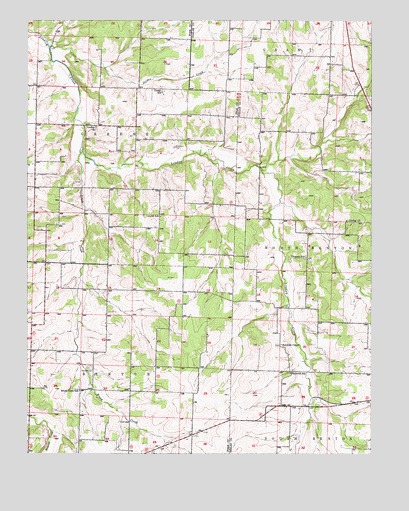
Buffalo NW, MO USGS Topographic Map
Click on map above to begin viewing in our Map Viewer.

This topographic map contains these locations and features:
Feature Name Type Latitude Longitude GNIS ID View Map
Breshears CemeteryCemeteryN37.7134°W93.1963°714668View Map
Brooks School (historical)SchoolN37.6800°W93.2474°732746View Map
Brush CreekStreamN37.7135°W93.2303°714824View Map
Brush Creek SchoolSchoolN37.6431°W93.2310°714872View Map
Carter SchoolSchoolN37.7295°W93.2010°715448View Map
Clifford (historical)Populated PlaceN37.7328°W93.2096°740109View Map
Concord SchoolSchoolN37.6936°W93.2016°716181View Map
Coy School (historical)SchoolN37.6609°W93.2024°732747View Map
Crescent SchoolSchoolN37.6817°W93.1488°716488View Map
Independence School (historical)SchoolN37.7250°W93.2474°732745View Map
Jensen Lake DamDamN37.6850°W93.1785°765434View Map
Jordan CreekStreamN37.7423°W93.2421°720435View Map
Lindley ChurchChurchN37.6923°W93.1344°721105View Map
Lindley ChurchChurchN37.7192°W93.2252°721106View Map
Little Lindley CreekStreamN37.6981°W93.1582°721263View Map
MathisPopulated PlaceN37.7217°W93.1655°740120View Map
Mission (historical)LocaleN37.6647°W93.1972°740112View Map
Ragsdale CemeteryCemeteryN37.6498°W93.2277°725065View Map
ReynoldsPopulated PlaceN37.6387°W93.1580°734991View Map
Reynolds CemeteryCemeteryN37.6564°W93.1594°2681502View Map
Reynolds ChapelChurchN37.6567°W93.1580°725235View Map
Reynolds SchoolSchoolN37.6481°W93.1544°725237View Map
Sergent Lake DamDamN37.6250°W93.1985°765433View Map
Township of South GreenCivilN37.7065°W93.2324°767226View Map

Note: Coordinates in the location and feature list above are referenced to NAD83 datum.


Copyright (C) 2008-2025 Ryan Niemi / Sunset Dynamics ... All Rights Reserved