TopoQuest Logo
Do you find TopoQuest useful?
Help keep TopoQuest running and adding new maps/features by donating!
Bitcoin:  19c7KJd3qBynnjoSw5npx9KScwjBe4ifkT
Litecoin:  LXs6TkuXGGXo1vDsWCkWVdjQX94eUKd6ui
Home View Maps Find Maps Find Places Resources & Links


Burlington NE, North Dakota Topographic Map

USGS Map Title: Burlington NE, ND
USGS Map MRC: 48101D3
DRG (GeoTIFF) Download: o48101d3.tif


Neighboring USGS Topographic Map Quads:


  Lansford SW, ND  
48101E4
 

  Lansford SE, ND  
48101E3
 

  Glenburn, ND  
48101E2
 

  Burlington NW, ND  
48101D4
 

  Burlington NE, ND  
48101D3
 

  Deering NW, ND  
48101D2
 

  Burlington, ND  
48101C4
 

  Burlington SE, ND  
48101C3
 

  Deering SW, ND  
48101C2


Map MRC Location:

N49°
W102°
N49°
W101°
H8 H7 H6 H5 H4 H3 H2 H1
G8 G7 G6 G5 G4 G3 G2 G1
F8 F7 F6 F5 F4 F3 F2 F1
E8 E7 E6 E5 E4 E3 E2 E1
D8 D7 D6 D5 D4 D3 D2 D1
C8 C7 C6 C5 C4 C3 C2 C1
B8 B7 B6 B5 B4 B3 B2 B1
A8 A7 A6 A5 A4 A3 A2 A1
N48°
W102°
N48°
W101°

Burlington NE, ND USGS 1:24K Topographic Map Preview:
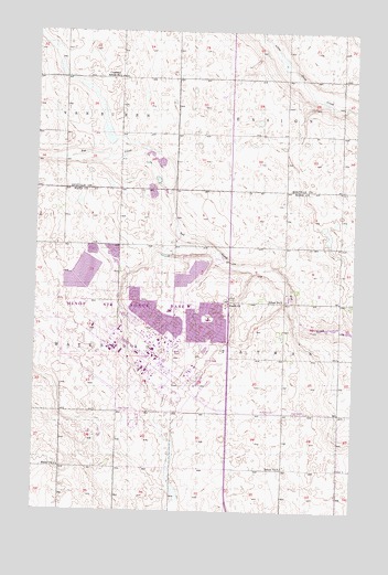
Burlington NE, ND USGS Topographic Map
Click on map above to begin viewing in our Map Viewer.

This topographic map contains these locations and features:
Feature Name Type Latitude Longitude GNIS ID View Map
Copeland School Number 1SchoolN48.4881°W101.3429°1028453View Map
Dakota Elementary SchoolSchoolN48.4250°W101.3071°2748086View Map
Department of Defense 5th Medical Group Ambulance ServiceBuildingN48.4170°W101.3015°2658757View Map
Lynch ChurchChurchN48.4295°W101.2999°1030051View Map
Memorial Middle SchoolSchoolN48.4287°W101.3149°2748088View Map
Minot Air Force BaseMilitaryN48.4258°W101.3457°2512295View Map
Minot Air Force BaseAirportN48.4173°W101.3503°2646287View Map
Minot Air Force Base Census Designated PlaceCensusN48.4210°W101.3383°2393133View Map
Minot Air Force Base Fire DepartmentBuildingN48.4132°W101.3393°2637514View Map
Minot Air Force Base LibraryBuildingN48.4194°W101.3246°2745697View Map
Minot Airforce Base Post OfficePost OfficeN48.4182°W101.3283°2781824View Map
Montessori of Minot SchoolSchoolN48.4282°W101.3005°2747785View Map
North Plains Elementary SchoolSchoolN48.4272°W101.3223°2748087View Map
Rough Rider Golf CourseLocaleN48.4145°W101.3024°2749174View Map
School Number 2SchoolN48.4300°W101.2771°1031704View Map
School Number 3SchoolN48.3864°W101.2777°1031843View Map
School Number 3SchoolN48.4439°W101.3560°1031847View Map
School Number 4SchoolN48.3864°W101.3654°1031940View Map
Township of TatmanCivilN48.4152°W101.2557°1759694View Map
United States Air Force Regional HospitalHospitalN48.4171°W101.3020°2733261View Map

Note: Coordinates in the location and feature list above are referenced to NAD83 datum.


Copyright (C) 2008-2025 Ryan Niemi / Sunset Dynamics ... All Rights Reserved