TopoQuest Logo
Do you find TopoQuest useful?
Help keep TopoQuest running and adding new maps/features by donating!
Bitcoin:  19c7KJd3qBynnjoSw5npx9KScwjBe4ifkT
Litecoin:  LXs6TkuXGGXo1vDsWCkWVdjQX94eUKd6ui
Home View Maps Find Maps Find Places Resources & Links


Alliance East, Nebraska Topographic Map

USGS Map Title: Alliance East, NE
USGS Map MRC: 42102A7
DRG (GeoTIFF) Download: o42102a7.tif


Neighboring USGS Topographic Map Quads:


  Berea Creek West, NE  
42102B8
 

  Berea Creek East, NE  
42102B7
 

  Krause Lake West, NE  
42102B6
 

  Alliance West, NE  
42102A8
 

  Alliance East, NE  
42102A7
 

  Jesse Lake, NE  
42102A6
 

  Cowboy Hill, NE  
41102H8
 

  Rush Lake, NE  
41102H7
 

  McCarthy Lake, NE  
41102H6


Map MRC Location:

N43°
W103°
N43°
W102°
H8 H7 H6 H5 H4 H3 H2 H1
G8 G7 G6 G5 G4 G3 G2 G1
F8 F7 F6 F5 F4 F3 F2 F1
E8 E7 E6 E5 E4 E3 E2 E1
D8 D7 D6 D5 D4 D3 D2 D1
C8 C7 C6 C5 C4 C3 C2 C1
B8 B7 B6 B5 B4 B3 B2 B1
A8 A7 A6 A5 A4 A3 A2 A1
N42°
W103°
N42°
W102°

Alliance East, NE USGS 1:24K Topographic Map Preview:
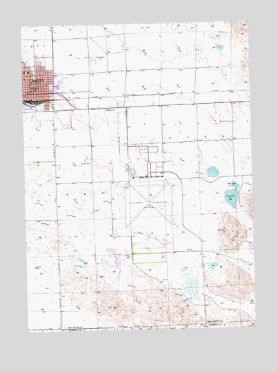
Alliance East, NE USGS Topographic Map
Click on map above to begin viewing in our Map Viewer.

This topographic map contains these locations and features:
Feature Name Type Latitude Longitude GNIS ID View Map
AlliancePopulated PlaceN42.1016°W102.8721°834978View Map
AllianceLocaleN42.0930°W102.8702°1827717View Map
Alliance Army Air Field (historical)MilitaryN42.0517°W102.8075°2091532View Map
Alliance Baptist ChurchChurchN42.0989°W102.8677°1827729View Map
Alliance Christian ChurchChurchN42.1027°W102.8641°1827730View Map
Alliance Fire DepartmentBuildingN42.0979°W102.8732°1827750View Map
Alliance High SchoolSchoolN42.1086°W102.8724°1827739View Map
Alliance Kiddy KampusSchoolN42.1180°W102.8663°1827744View Map
Alliance Medical CenterHospitalN42.1166°W102.8694°1827792View Map
Alliance Middle SchoolSchoolN42.1061°W102.8724°1827740View Map
Alliance Municipal AirportAirportN42.0614°W102.8087°837467View Map
Alliance Municipal Golf CourseLocaleN42.0702°W102.8116°1827798View Map
Alliance Police DepartmentBuildingN42.0996°W102.8697°1827749View Map
Alliance Post OfficePost OfficeN42.0985°W102.8704°1827718View Map
Alliance Public LibraryBuildingN42.0997°W102.8710°1827779View Map
Alliance SpeedwayLocaleN42.0916°W102.8505°1827777View Map
Bower ParkParkN42.0955°W102.8627°1827780View Map
Bower-Shankland FieldParkN42.0955°W102.8627°1827781View Map
Box Butte County CourthouseBuildingN42.0997°W102.8705°1827751View Map
Box Butte County SheriffBuildingN42.0997°W102.8698°1827752View Map
Box Butte General HospitalHospitalN42.1167°W102.8697°1827791View Map
Box Butte Medical CenterHospitalN42.1166°W102.8694°1827789View Map
Bulldog StadiumParkN42.1075°W102.8696°1827773View Map
Burlington Locomotive 719 Historical MarkerParkN42.1111°W102.8710°1827794View Map
Calvary Assembly of God ChurchChurchN42.0972°W102.8538°1827727View Map
Central Elementary SchoolSchoolN42.1016°W102.8699°1827741View Map
Central ParkParkN42.1041°W102.8685°1827775View Map
Church of GodChurchN42.0930°W102.8608°1827723View Map
Eastpoint Public SchoolSchoolN42.0841°W102.7610°828984View Map
First Baptist ChurchChurchN42.1041°W102.8663°1827726View Map
First Christian ChurchChurchN42.1033°W102.8708°1827719View Map
First United Pentecostal ChurchChurchN42.1044°W102.8708°1827720View Map
Good Samaritan VillageHospitalN42.1008°W102.8605°1827785View Map
Grandview Elementary SchoolSchoolN42.1008°W102.8619°1827742View Map
Greenwood CemeteryCemeteryN42.1114°W102.8374°829687View Map
Highland Park Care CenterHospitalN42.1108°W102.8688°1827788View Map
Holy Rosary Catholic ChurchChurchN42.1061°W102.8744°1827725View Map
Immanuel Lutheran ChurchChurchN42.1052°W102.8713°1827721View Map
Jensens Wheel In Camper CourtLocaleN42.1016°W102.8721°1827696View Map
Knight Museum of the High Plains HeritageBuildingN42.1041°W102.8685°1827776View Map
Laing ParkParkN42.1139°W102.8727°1827774View Map
Meadows Trailer CourtPopulated PlaceN42.1016°W102.8721°1827755View Map
Panhandle Church of ChristChurchN42.0975°W102.8727°1827728View Map
Saint Agnes AcademySchoolN42.1058°W102.8744°1827748View Map
Saint Matthews Episcopal ChurchChurchN42.1105°W102.8738°1827724View Map
Sallows Arboretum and ConservatoryLocaleN42.1055°W102.8685°1827769View Map
Sandhills Drive-In TheaterLocaleN42.1022°W102.8566°1827793View Map
Sandhills Family Health CenterHospitalN42.1166°W102.8694°1827790View Map
School Number 2SchoolN42.0905°W102.8296°836367View Map
Sewer Lake Number 1LakeN42.0532°W102.7622°837237View Map
Sewer Lake Number 2LakeN42.0580°W102.7594°837238View Map
Snake CreekStreamN42.0258°W102.7505°835978View Map
Sudman FieldParkN42.1111°W102.8727°1827770View Map
Sunset Motel and RV ParkLocaleN42.1016°W102.8721°1827697View Map
Tower Plaza Mobile Home ParkPopulated PlaceN42.1016°W102.8721°1827754View Map
Trailerville CourtPopulated PlaceN42.1016°W102.8721°1827753View Map
United Methodist ChurchChurchN42.1011°W102.8705°1827722View Map
Western Nebraska Community College - Alliance CenterSchoolN42.0975°W102.8724°1827745View Map

Note: Coordinates in the location and feature list above are referenced to NAD83 datum.


Copyright (C) 2008-2024 Ryan Niemi / Sunset Dynamics ... All Rights Reserved