TopoQuest Logo
Do you find TopoQuest useful?
Help keep TopoQuest running and adding new maps/features by donating!
Bitcoin:  19c7KJd3qBynnjoSw5npx9KScwjBe4ifkT
Litecoin:  LXs6TkuXGGXo1vDsWCkWVdjQX94eUKd6ui
Home View Maps Find Maps Find Places Resources & Links


Burnt Mountain, Wyoming Topographic Map

USGS Map Title: Burnt Mountain, WY
USGS Map MRC: 43110E2
DRG (GeoTIFF) Download: o43110e2.tif


Neighboring USGS Topographic Map Quads:


  Green Mountain, WY  
43110F3
 

  Tripod Peak, WY  
43110F2
 

  Lava Mountain, WY  
43110F1
 

  Upper Slide Lake, WY  
43110E3
 

  Burnt Mountain, WY  
43110E2
 

  Sheridan Pass, WY  
43110E1
 

  Darwin Peak, WY  
43110D3
 

  Ouzel Falls, WY  
43110D2
 

  Mosquito Lake, WY  
43110D1


Map MRC Location:

N44°
W111°
N44°
W110°
H8 H7 H6 H5 H4 H3 H2 H1
G8 G7 G6 G5 G4 G3 G2 G1
F8 F7 F6 F5 F4 F3 F2 F1
E8 E7 E6 E5 E4 E3 E2 E1
D8 D7 D6 D5 D4 D3 D2 D1
C8 C7 C6 C5 C4 C3 C2 C1
B8 B7 B6 B5 B4 B3 B2 B1
A8 A7 A6 A5 A4 A3 A2 A1
N43°
W111°
N43°
W110°

Burnt Mountain, WY USGS 1:24K Topographic Map Preview:
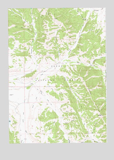
Burnt Mountain, WY USGS Topographic Map
Click on map above to begin viewing in our Map Viewer.

This topographic map contains these locations and features:
Feature Name Type Latitude Longitude GNIS ID View Map
Alkali GulchValleyN43.5297°W110.1891°1584775View Map
Bacon CreekStreamN43.5547°W110.2182°1597859View Map
Bang CreekStreamN43.5016°W110.1730°1597908View Map
Bar B CreekStreamN43.5044°W110.1460°1585100View Map
Bell CreekStreamN43.5522°W110.1252°1598097View Map
Bridge CreekStreamN43.5030°W110.2271°1598369View Map
Bull CreekStreamN43.6147°W110.1488°1598484View Map
Bull Creek Patrol CabinLocaleN43.6144°W110.1499°1586097View Map
Burnt MountainSummitN43.5255°W110.1313°1586176View Map
Burnt RidgeRidgeN43.5374°W110.1413°1598525View Map
Deer CreekStreamN43.5766°W110.1819°1587481View Map
Deer Creek LookoutLocaleN43.6155°W110.1910°1587495View Map
Deer Creek MountainSummitN43.6149°W110.1910°1604770View Map
Dog CreekStreamN43.6116°W110.2169°1587686View Map
Dude CreekStreamN43.5019°W110.1438°1599400View Map
Falcona Claims MineMineN43.5711°W110.2155°1704361View Map
Fish CreekStreamN43.5499°W110.2496°1588502View Map
Hackamore CreekStreamN43.5652°W110.1288°1600156View Map
Harness GulchValleyN43.6008°W110.1557°1589319View Map
Little Sohare CreekStreamN43.6019°W110.2138°1601044View Map
North Fork Fish CreekStreamN43.5738°W110.1819°1601771View Map
Packsaddle CreekStreamN43.6230°W110.1416°1601985View Map
Poison CreekStreamN43.5474°W110.2102°1592901View Map
Pond CreekStreamN43.5222°W110.1846°1592945View Map
Purdy Basin TrailTrailN43.5805°W110.1260°1608746View Map
Purdy CreekStreamN43.5716°W110.1452°1602328View Map
Rat CreekStreamN43.5030°W110.1505°1593178View Map
Sohare CreekStreamN43.6102°W110.2180°1603063View Map
South Fork Fish CreekStreamN43.5738°W110.1821°1603137View Map
Trail CreekStreamN43.5644°W110.1966°1595666View Map
Water GulchValleyN43.5202°W110.1852°1596074View Map
Wolf GulchValleyN43.5480°W110.2099°1596579View Map

Note: Coordinates in the location and feature list above are referenced to NAD83 datum.


Copyright (C) 2008-2025 Ryan Niemi / Sunset Dynamics ... All Rights Reserved