TopoQuest Logo
Do you find TopoQuest useful?
Help keep TopoQuest running and adding new maps/features by donating!
Bitcoin:  19c7KJd3qBynnjoSw5npx9KScwjBe4ifkT
Litecoin:  LXs6TkuXGGXo1vDsWCkWVdjQX94eUKd6ui
Home View Maps Find Maps Find Places Resources & Links


Burwell, Nebraska Topographic Map

USGS Map Title: Burwell, NE
USGS Map MRC: 41099G2
DRG (GeoTIFF) Download: o41099g2.tif


Neighboring USGS Topographic Map Quads:


  Taylor NE, NE  
41099H3
 

  Burwell NW, NE  
41099H2
 

  Burwell NE, NE  
41099H1
 

  Taylor SE, NE  
41099G3
 

  Burwell, NE  
41099G2
 

  Burwell SE, NE  
41099G1
 

  Sargent East, NE  
41099F3
 

  Comstock NW, NE  
41099F2
 

  Elyria, NE  
41099F1


Map MRC Location:

N42°
W100°
N42°
W99°
H8 H7 H6 H5 H4 H3 H2 H1
G8 G7 G6 G5 G4 G3 G2 G1
F8 F7 F6 F5 F4 F3 F2 F1
E8 E7 E6 E5 E4 E3 E2 E1
D8 D7 D6 D5 D4 D3 D2 D1
C8 C7 C6 C5 C4 C3 C2 C1
B8 B7 B6 B5 B4 B3 B2 B1
A8 A7 A6 A5 A4 A3 A2 A1
N41°
W100°
N41°
W99°

Burwell, NE USGS 1:24K Topographic Map Preview:
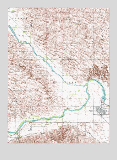
Burwell, NE USGS Topographic Map
Click on map above to begin viewing in our Map Viewer.

This topographic map contains these locations and features:
Feature Name Type Latitude Longitude GNIS ID View Map
Assembly of God ChurchChurchN41.7839°W99.1318°1847544View Map
Banner SchoolSchoolN41.7986°W99.1251°827179View Map
Berean Fundamental ChurchChurchN41.7822°W99.1268°1847539View Map
Buckshot BayBayN41.8361°W99.2323°1847562View Map
BurwellPopulated PlaceN41.7817°W99.1332°827808View Map
Burwell Baptist ChurchChurchN41.7797°W99.1259°1847542View Map
Burwell City ParkParkN41.7889°W99.1337°1847549View Map
Burwell City Park CampgroundLocaleN41.7889°W99.1337°1847548View Map
Burwell Elementary SchoolSchoolN41.7806°W99.1290°1847547View Map
Burwell Family Practice ClinicHospitalN41.7778°W99.1351°1847531View Map
Burwell Junior-Senior High SchoolSchoolN41.7789°W99.1273°1847546View Map
Burwell LibraryBuildingN41.7814°W99.1332°1847532View Map
Burwell Medical ClinicHospitalN41.7845°W99.1334°1847533View Map
Burwell Post OfficePost OfficeN41.7808°W99.1349°1847528View Map
Burwell Rural Fire DistrictBuildingN41.7824°W99.1379°2553332View Map
Burwell-Sumter Diversion ReservoirReservoirN41.7917°W99.1304°1769549View Map
Calamus Country Camper CourtLocaleN41.7817°W99.1332°1847534View Map
Calamus Fish HatcheryLocaleN41.8292°W99.2184°1847563View Map
Calamus Golf CourseLocaleN41.8111°W99.1948°1847561View Map
Calamus RiverStreamN41.8045°W99.1515°827843View Map
Calamus Valley Historical MarkerParkN41.8389°W99.2032°1847566View Map
City of BurwellCivilN41.7800°W99.1342°2393477View Map
Community Christian ChurchChurchN41.7817°W99.1332°1847545View Map
Community Memorial Health CenterHospitalN41.7845°W99.1357°1847552View Map
Community Memorial HospitalHospitalN41.7845°W99.1357°1847550View Map
Community Memorial Nursing HomeHospitalN41.7845°W99.1357°1847551View Map
Cottonwood CemeteryCemeteryN41.7675°W99.1444°828372View Map
Cram FieldAirportN41.7751°W99.1480°837509View Map
Evangelical Wesleyan ChurchChurchN41.7808°W99.1395°1847540View Map
First Christian ChurchChurchN41.7789°W99.1365°1847541View Map
Garfield County CourthouseBuildingN41.7803°W99.1351°1847560View Map
Garfield County Historical MarkerParkN41.7803°W99.1351°1847554View Map
Garfield County Historical MuseumBuildingN41.7808°W99.1345°1847529View Map
Garfield County Sheriff's OfficeBuildingN41.7802°W99.1350°1847553View Map
Gideon SchoolSchoolN41.8617°W99.1662°829511View Map
Goldenrod SchoolSchoolN41.8270°W99.1826°829561View Map
Hillsdale SchoolSchoolN41.7961°W99.2415°830017View Map
Iverson Chiropractic ClinicHospitalN41.7811°W99.1357°1847530View Map
Little York Point Park HeadquartersLocaleN41.8389°W99.2032°1847565View Map
Littlefield CemeteryCemeteryN41.8094°W99.1393°830803View Map
Mirdan Canal State Wildlife Management AreaParkN41.7728°W99.1907°1847524View Map
North Loup DamDamN41.7910°W99.1335°831709View Map
North Loup DamDamN41.7917°W99.1304°1769548View Map
North Loup Project Historical MarkerParkN41.8389°W99.2032°1847567View Map
Nunda Post Office (historical)Post OfficeN41.8722°W99.2498°1845143View Map
Nunda SchoolSchoolN41.8711°W99.2423°831776View Map
Parker CemeteryCemeteryN41.8203°W99.1826°831983View Map
Rainbow Trailer CourtPopulated PlaceN41.7817°W99.1332°1847535View Map
Riverside ParkParkN41.7895°W99.1320°832587View Map
Riverside SchoolSchoolN41.7697°W99.1918°832596View Map
Riverview Public SchoolSchoolN41.7989°W99.1826°832570View Map
Rockford Election PrecinctCivilN41.8167°W99.1722°1929253View Map
Sacred Heart ChurchChurchN41.7800°W99.1345°1847536View Map
Saint Johns Lutheran ChurchChurchN41.7856°W99.1348°1847538View Map
Sioux CreekStreamN41.7606°W99.2376°833463View Map
Sloux Creek SchoolSchoolN41.7556°W99.2490°833491View Map
Taylor-Ord CanalCanalN41.7617°W99.1548°834054View Map
Township of RockfordCivilN41.7917°W99.1670°1847559View Map
United Church of ChristChurchN41.7808°W99.1332°1847537View Map
United Methodist ChurchChurchN41.7800°W99.1373°1847543View Map
Virginia Smith DamDamN41.8310°W99.2139°1847564View Map
Windy HillSummitN41.8167°W99.1251°834810View Map

Note: Coordinates in the location and feature list above are referenced to NAD83 datum.


Copyright (C) 2008-2025 Ryan Niemi / Sunset Dynamics ... All Rights Reserved