TopoQuest Logo
Do you find TopoQuest useful?
Help keep TopoQuest running and adding new maps/features by donating!
Bitcoin:  19c7KJd3qBynnjoSw5npx9KScwjBe4ifkT
Litecoin:  LXs6TkuXGGXo1vDsWCkWVdjQX94eUKd6ui
Home View Maps Find Maps Find Places Resources & Links


Busted Butte, Nevada Topographic Map

USGS Map Title: Busted Butte, NV
USGS Map MRC: 36116G4
DRG (GeoTIFF) Download: o36116g4.tif


Neighboring USGS Topographic Map Quads:


  East of Beatty Mountain, NV  
36116H5
 

  Topopah Spring NW, NV  
36116H4
 

  Topopah Spring, NV  
36116H3
 

  Crater Flat, NV  
36116G5
 

  Busted Butte, NV  
36116G4
 

  Jackass Flats, NV  
36116G3
 

  Big Dune, NV  
36116F5
 

  Amargosa Valley, NV  
36116F4
 

  Striped Hills, NV  
36116F3


Map MRC Location:

N37°
W117°
N37°
W116°
H8 H7 H6 H5 H4 H3 H2 H1
G8 G7 G6 G5 G4 G3 G2 G1
F8 F7 F6 F5 F4 F3 F2 F1
E8 E7 E6 E5 E4 E3 E2 E1
D8 D7 D6 D5 D4 D3 D2 D1
C8 C7 C6 C5 C4 C3 C2 C1
B8 B7 B6 B5 B4 B3 B2 B1
A8 A7 A6 A5 A4 A3 A2 A1
N36°
W117°
N36°
W116°

Busted Butte, NV USGS 1:24K Topographic Map Preview:
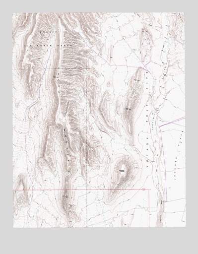
Busted Butte, NV USGS Topographic Map
Click on map above to begin viewing in our Map Viewer.

This topographic map contains these locations and features:
Feature Name Type Latitude Longitude GNIS ID View Map
Alice PointSummitN36.8639°W116.4036°2571432View Map
Ambush PassGapN36.7869°W116.4292°2571433View Map
Boundary RidgeRidgeN36.8375°W116.4422°2571438View Map
Bow RidgeRidgeN36.8300°W116.4314°2571439View Map
Busted ButteSummitN36.7827°W116.4195°849712View Map
Creosote RidgeRidgeN36.7506°W116.4472°2571448View Map
Dune WashValleyN36.7853°W116.3967°2571451View Map
False CrestRidgeN36.8236°W116.4569°2571462View Map
Fortymile CanyonValleyN36.7902°W116.3967°856246View Map
Fran RidgeRidgeN36.8431°W116.4069°2571468View Map
Iron RidgeRidgeN36.7806°W116.4583°2571477View Map
Iron TankReservoirN36.7647°W116.3912°851849View Map
Knotted RidgeRidgeN36.8675°W116.4931°2571527View Map
Little ProwSummitN36.8708°W116.4658°2571533View Map
Pagany WashStreamN36.8592°W116.4258°2571534View Map
Plug HillSummitN36.8222°W116.4806°2571535View Map
Quail RidgeRidgeN36.8028°W116.4514°2571536View Map
Quartz Mountain Camp (historical)LocaleN36.8338°W116.3978°851841View Map
Sear ValleyValleyN36.7736°W116.4806°2571537View Map
Sever WashStreamN36.8186°W116.3967°2571538View Map
Solitario CanyonValleyN36.8263°W116.4814°845097View Map
Stairs RidgeRidgeN36.7986°W116.4486°2571561View Map
Teacup WashStreamN36.8625°W116.4508°2571563View Map
Well J-TwelveWellN36.7650°W116.3912°844703View Map
Yucca CrestRidgeN36.8708°W116.4658°2571572View Map
Yucca WashStreamN36.8641°W116.3889°845082View Map

Note: Coordinates in the location and feature list above are referenced to NAD83 datum.


Copyright (C) 2008-2025 Ryan Niemi / Sunset Dynamics ... All Rights Reserved