TopoQuest Logo
Do you find TopoQuest useful?
Help keep TopoQuest running and adding new maps/features by donating!
Bitcoin:  19c7KJd3qBynnjoSw5npx9KScwjBe4ifkT
Litecoin:  LXs6TkuXGGXo1vDsWCkWVdjQX94eUKd6ui
Home View Maps Find Maps Find Places Resources & Links


Caballo, New Mexico Topographic Map

USGS Map Title: Caballo, NM
USGS Map MRC: 32107H3
DRG (GeoTIFF) Download: o32107h3.tif


Neighboring USGS Topographic Map Quads:


  Saladone Tank, NM  
33107A4
 

  Williamsburg, NM  
33107A3
 

  Palomas Gap, NM  
33107A2
 

  Skute Stone Arroyo, NM  
32107H4
 

  Caballo, NM  
32107H3
 

  Apache Gap, NM  
32107H2
 

  Clark Spring Canyon, NM  
32107G4
 

  Garfield, NM  
32107G3
 

  McLeod Tank, NM  
32107G2


Map MRC Location:

N33°
W108°
N33°
W107°
H8 H7 H6 H5 H4 H3 H2 H1
G8 G7 G6 G5 G4 G3 G2 G1
F8 F7 F6 F5 F4 F3 F2 F1
E8 E7 E6 E5 E4 E3 E2 E1
D8 D7 D6 D5 D4 D3 D2 D1
C8 C7 C6 C5 C4 C3 C2 C1
B8 B7 B6 B5 B4 B3 B2 B1
A8 A7 A6 A5 A4 A3 A2 A1
N32°
W108°
N32°
W107°

Caballo, NM USGS 1:24K Topographic Map Preview:
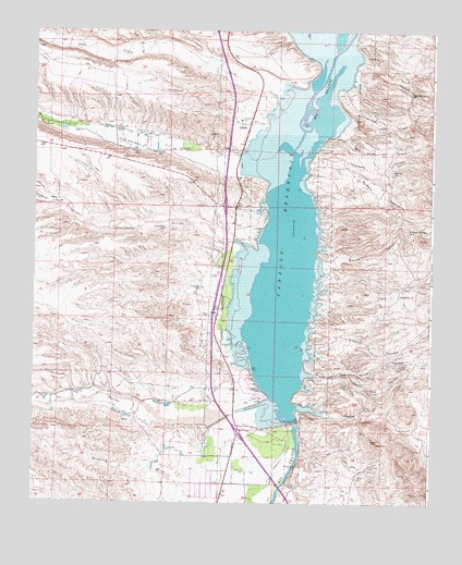
Caballo, NM USGS Topographic Map
Click on map above to begin viewing in our Map Viewer.

This topographic map contains these locations and features:
Feature Name Type Latitude Longitude GNIS ID View Map
27 44 3 Water WellWellN32.9751°W107.3706°923045View Map
27-37-3 Water WellWellN32.9701°W107.3392°923037View Map
27-38 3 Water WellWellN32.9701°W107.3350°923042View Map
27-39 3 Water WellWellN32.9701°W107.3392°923040View Map
27-40 3 Water WellWellN32.9701°W107.3392°923039View Map
27-41 3 Water WellWellN32.9701°W107.3392°923038View Map
27-44 3 Water WellWellN32.9742°W107.3695°923054View Map
27-473 Water WellWellN32.9690°W107.3364°923033View Map
27-48 3 Water WellWellN32.9690°W107.3364°923034View Map
27-50 3 Water WellWellN32.9662°W107.3350°923057View Map
27-55 3 Water WellWellN32.9701°W107.3484°923041View Map
27-63 3 Water WellWellN32.9742°W107.3695°923053View Map
27-64 3 Water WellWellN32.9742°W107.3695°923052View Map
3 LRG-76 Water WellWellN32.8854°W107.3311°923029View Map
40 B Water WellWellN32.9751°W107.3086°923044View Map
47 A Water WellWellN32.9692°W107.3409°923035View Map
48 Water WellWellN32.9690°W107.3364°923060View Map
Apache CanyonValleyN32.9009°W107.2928°885825View Map
Apache TankReservoirN32.8920°W107.2503°901038View Map
Arrey Derry Fire Department Station 1BuildingN32.8803°W107.3128°2657934View Map
Ash CanyonValleyN32.9887°W107.2742°885916View Map
Ash SpringSpringN32.9837°W107.2572°885920View Map
Bat Cave CanyonValleyN32.9281°W107.2850°886108View Map
Black BeautyMineN32.8917°W107.2631°917693View Map
Black Beauty GroupMineN32.8884°W107.2659°917973View Map
Blondie ClaimsMineN32.9609°W107.2572°917929View Map
Burbank CanyonValleyN32.9612°W107.2897°886918View Map
CaballoPopulated PlaceN32.9756°W107.3078°898738View Map
Caballo CanyonValleyN32.9090°W107.2875°887038View Map
Caballo CemeteryCemeteryN32.9245°W107.3197°887039View Map
Caballo Census Designated PlaceCensusN32.9806°W107.3075°2584062View Map
Caballo Community ChurchChurchN32.9756°W107.3081°902732View Map
Caballo DamDamN32.8963°W107.2933°887041View Map
Caballo Fire RescueBuildingN32.9809°W107.3065°2657770View Map
Caballo Lake InterchangeCrossingN32.8959°W107.3125°924799View Map
Caballo Mountain Mining and LeachingMineN32.8876°W107.2689°917930View Map
Caballo Post OfficePost OfficeN32.9756°W107.3078°937648View Map
Caballo ReservoirReservoirN32.9583°W107.2924°887043View Map
Caballo Weather StationLocaleN32.9756°W107.3078°931860View Map
Chambers CanyonValleyN32.9656°W107.2884°887418View Map
Dredge Tailings 1MineN32.9115°W107.2572°917926View Map
Dredge Tailings 2MineN32.9065°W107.2756°917927View Map
Dredge Tailings FiveMineN32.9084°W107.2853°917453View Map
Dredge Tailings FourMineN32.9006°W107.2678°917452View Map
Dredge Tailings SixMineN32.9084°W107.2761°917454View Map
Flordillo CanyonValleyN32.9170°W107.2881°889103View Map
Granite CanyonValleyN32.9381°W107.2845°889545View Map
Granite PeakMineN32.9448°W107.2564°917922View Map
Granite SpringSpringN32.9473°W107.2572°889549View Map
Greenhorn ArroyoStreamN32.9420°W107.3072°889603View Map
Greyback ArroyoStreamN32.9501°W107.3628°889626View Map
LA 1119LocaleN32.9756°W107.3072°936032View Map
LA 19 Water WellWellN32.9701°W107.3392°923036View Map
LA 42 Water WellWellN32.9690°W107.3364°923059View Map
LA-2S Water WellWellN32.9770°W107.3656°923046View Map
Las Animas CreekStreamN32.9676°W107.3036°907860View Map
Longbottom CanyonValleyN32.9840°W107.2786°891312View Map
Longbottom Canyon Ruin Historic SiteLocaleN32.9840°W107.2786°934405View Map
Lyda K MineMineN32.8845°W107.2667°917690View Map
Lyda-KMineN32.8848°W107.2681°917937View Map
OasisPopulated PlaceN32.9245°W107.3172°898828View Map
Oasis Census Designated PlaceCensusN32.9277°W107.3164°2584168View Map
Percha CreekStreamN32.9023°W107.3003°909566View Map
Percha Diversion DamDamN32.8965°W107.3156°893186View Map
PittsburgMineN32.9056°W107.2700°917688View Map
Pulido CanyonValleyN32.9098°W107.2878°893547View Map
Red Cloud ClaimsMineN32.8779°W107.2556°917443View Map
Seco CreekStreamN32.9781°W107.2961°910902View Map
Wild Horse CanyonValleyN32.9740°W107.2784°896593View Map

Note: Coordinates in the location and feature list above are referenced to NAD83 datum.


Copyright (C) 2008-2024 Ryan Niemi / Sunset Dynamics ... All Rights Reserved