TopoQuest Logo
Do you find TopoQuest useful?
Help keep TopoQuest running and adding new maps/features by donating!
Bitcoin:  19c7KJd3qBynnjoSw5npx9KScwjBe4ifkT
Litecoin:  LXs6TkuXGGXo1vDsWCkWVdjQX94eUKd6ui
Home View Maps Find Maps Find Places Resources & Links


Calcutta Lake, Nevada Topographic Map

USGS Map Title: Calcutta Lake, NV
USGS Map MRC: 41119G6
DRG (GeoTIFF) Download: o41119g6.tif


Neighboring USGS Topographic Map Quads:


  Little Coleman Canyon, NV  
41119H7
 

  Coleman Canyon, NV  
41119H6
 

  Rye Creek, NV  
41119H5
 

  Mosquito Valley, NV  
41119G7
 

  Calcutta Lake, NV  
41119G6
 

  Bald Mountain, NV  
41119G5
 

  Alkali Lake, NV  
41119F7
 

  Massacre Lake NW, NV  
41119F6
 

  Massacre Lake, NV  
41119F5


Map MRC Location:

N42°
W120°
N42°
W119°
H8 H7 H6 H5 H4 H3 H2 H1
G8 G7 G6 G5 G4 G3 G2 G1
F8 F7 F6 F5 F4 F3 F2 F1
E8 E7 E6 E5 E4 E3 E2 E1
D8 D7 D6 D5 D4 D3 D2 D1
C8 C7 C6 C5 C4 C3 C2 C1
B8 B7 B6 B5 B4 B3 B2 B1
A8 A7 A6 A5 A4 A3 A2 A1
N41°
W120°
N41°
W119°

Calcutta Lake, NV USGS 1:24K Topographic Map Preview:
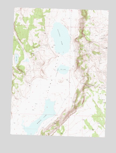
Calcutta Lake, NV USGS Topographic Map
Click on map above to begin viewing in our Map Viewer.

This topographic map contains these locations and features:
Feature Name Type Latitude Longitude GNIS ID View Map
Antelope SpringSpringN41.8300°W119.7231°838480View Map
Beebe SpringSpringN41.7665°W119.6564°846428View Map
Biebe SpringSpringN41.7524°W119.6847°838706View Map
Board Corral RanchLocaleN41.7838°W119.6697°847249View Map
Brush SpringSpringN41.7841°W119.6300°839105View Map
Buck PastureFlatN41.7868°W119.6324°839112View Map
Calcutta LakeLakeN41.8459°W119.6882°847263View Map
Calcutta RanchLocaleN41.8368°W119.6985°847264View Map
Coffey Reservoir (historical)ReservoirN41.7868°W119.7477°846427View Map
Cottonwood CanyonValleyN41.8013°W119.6685°839727View Map
Cottonwood SpringSpringN41.7997°W119.6509°839775View Map
Cow LakeLakeN41.8154°W119.6840°839807View Map
Cow Lake WellWellN41.8121°W119.6922°846430View Map
Horse LakeLakeN41.8247°W119.7460°841099View Map
MC SpringsSpringN41.7624°W119.6941°841892View Map
Middle LakeLakeN41.7657°W119.7117°842084View Map
Painted Point RangeRangeN41.7929°W119.6274°846422View Map
Rock FlatFlatN41.8368°W119.7397°843279View Map
Sage Hen SpringsSpringN41.7568°W119.6444°843435View Map
True SpringSpringN41.7632°W119.6347°846429View Map
Willow CreekStreamN41.7868°W119.7022°844898View Map
Wimer PlacePopulated PlaceN41.7982°W119.7263°856173View Map

Note: Coordinates in the location and feature list above are referenced to NAD83 datum.


Copyright (C) 2008-2025 Ryan Niemi / Sunset Dynamics ... All Rights Reserved