TopoQuest Logo
Do you find TopoQuest useful?
Help keep TopoQuest running and adding new maps/features by donating!
Bitcoin:  19c7KJd3qBynnjoSw5npx9KScwjBe4ifkT
Litecoin:  LXs6TkuXGGXo1vDsWCkWVdjQX94eUKd6ui
Home View Maps Find Maps Find Places Resources & Links


Calhoun Falls, South Carolina Topographic Map

USGS Map Title: Calhoun Falls, SC
USGS Map MRC: 34082A5
DRG (GeoTIFF) Download: o34082a5.tif


Neighboring USGS Topographic Map Quads:


  Lowndesville, SC  
34082B6
 

  Latimer, SC  
34082B5
 

  Abbeville West, SC  
34082B4
 

  Heardmont, GA  
34082A6
 

  Calhoun Falls, SC  
34082A5
 

  Calhoun Creek, SC  
34082A4
 

  Broad, GA  
33082H6
 

  Chennault, GA  
33082H5
 

  Willington, SC  
33082H4


Map MRC Location:

N35°
W83°
N35°
W82°
H8 H7 H6 H5 H4 H3 H2 H1
G8 G7 G6 G5 G4 G3 G2 G1
F8 F7 F6 F5 F4 F3 F2 F1
E8 E7 E6 E5 E4 E3 E2 E1
D8 D7 D6 D5 D4 D3 D2 D1
C8 C7 C6 C5 C4 C3 C2 C1
B8 B7 B6 B5 B4 B3 B2 B1
A8 A7 A6 A5 A4 A3 A2 A1
N34°
W83°
N34°
W82°

Calhoun Falls, SC USGS 1:24K Topographic Map Preview:
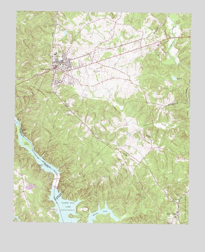
Calhoun Falls, SC USGS Topographic Map
Click on map above to begin viewing in our Map Viewer.

This topographic map contains these locations and features:
Feature Name Type Latitude Longitude GNIS ID View Map
Abbeville County Fire Department Calhoun FallsBuildingN34.0920°W82.5939°2578282View Map
Beer Garden CreekStreamN34.0387°W82.6051°1229392View Map
Boyd CemeteryCemeteryN34.0448°W82.5262°1229451View Map
Boyds Chapel School (historical)SchoolN34.0432°W82.5512°1229310View Map
Brough CemeteryCemeteryN34.0246°W82.5371°1229460View Map
Burnt House School (historical)SchoolN34.0360°W82.5801°1229030View Map
Buzzard Island (historical)IslandN34.0346°W82.6037°312118View Map
Calhoun BranchStreamN34.0621°W82.6240°1229499View Map
Calhoun FallsPopulated PlaceN34.0923°W82.5957°1247089View Map
Calhoun Falls Church of GodChurchN34.0954°W82.5860°1229032View Map
Calhoun Falls Country ClubLocaleN34.1134°W82.5940°1242363View Map
Calhoun Falls Country Club LakeReservoirN34.1124°W82.5898°1237876View Map
Calhoun Falls High SchoolSchoolN34.0996°W82.5965°1229033View Map
Calhoun Falls ParkParkN34.0232°W82.5912°1247090View Map
Calhoun Falls Police DepartmentBuildingN34.0924°W82.5963°2734302View Map
Calhoun Falls United Methodist ChurchChurchN34.0937°W82.5893°1229034View Map
Calhoun Ferry (historical)CrossingN34.0596°W82.6240°1229035View Map
Calhoun Ferry (historical)CrossingN34.0596°W82.6240°347803View Map
Chesnut Hill (historical)Populated PlaceN34.1154°W82.5040°1229048View Map
Church of God of ProphecyChurchN34.1001°W82.5893°1229049View Map
Coffer CreekStreamN34.0204°W82.5918°1229572View Map
Dresden (historical)Populated PlaceN34.1096°W82.5351°1229065View Map
Edgewood ParkParkN34.0998°W82.5929°1229677View Map
Ellison School (historical)SchoolN34.0834°W82.5957°1247659View Map
First Baptist ChurchChurchN34.0937°W82.5929°1229078View Map
Glovers ChurchChurchN34.0648°W82.5815°1229732View Map
Goat Island (historical)IslandN34.0473°W82.6157°314658View Map
Harpers ChapelChurchN34.0007°W82.5121°1245917View Map
HesterPopulated PlaceN34.0704°W82.5871°1229791View Map
Hester CemeteryCemeteryN34.0640°W82.5874°1245966View Map
Hester Memorial AirportAirportN34.0910°W82.5695°1251859View Map
John C Calhoun Elementary SchoolSchoolN34.1037°W82.5979°1229092View Map
Lake ForrestReservoirN34.0779°W82.5632°339960View Map
Lake Forrest Subdivision DamDamN34.0751°W82.5682°339959View Map
Little River Volunteer Fire DepartmentBuildingN34.0016°W82.5056°2578360View Map
Manor CreekStreamN34.0451°W82.5993°1246524View Map
McAllister ChapelChurchN34.0512°W82.5276°1246573View Map
McKenley CreekStreamN34.1248°W82.5379°1229989View Map
Mount CarmelPopulated PlaceN34.0073°W82.5071°1230047View Map
Mount Carmel CemeteryCemeteryN34.0121°W82.5096°1229235View Map
Mount Carmel Census Designated PlaceCensusN34.0185°W82.5044°2403309View Map
Mount Carmel Historic DistrictParkN34.0093°W82.5071°1229236View Map
Mount Olive Holiness Church of GodChurchN34.0834°W82.5935°1229109View Map
Northside Baptist ChurchChurchN34.0923°W82.5910°1229115View Map
Petersburg School (historical)SchoolN34.0157°W82.6224°347888View Map
Reileys School (historical)SchoolN34.0734°W82.5412°1229124View Map
Richard B Russell DamDamN34.0255°W82.5953°2612500View Map
Rock Ford ChurchChurchN34.0146°W82.5096°1250415View Map
Sherard LakeLakeN34.0779°W82.5632°1230324View Map
Smith Store (historical)LocaleN34.0765°W82.5957°1229144View Map
South Carolina Noname 01004 D-3035 DamDamN34.0851°W82.5099°1237874View Map
South Carolina Noname 01005 D-3034 DamDamN34.1134°W82.5899°1237875View Map
Springfield Baptist ChurchChurchN34.1165°W82.5968°1251013View Map
Tates Grove Baptist CemeteryCemeteryN34.0282°W82.6199°347914View Map
Tates Grove ChurchChurchN34.0293°W82.6199°323929View Map
Town of Calhoun FallsCivilN34.0932°W82.5963°2405364View Map
Trotters ShoalsBarN34.0548°W82.6204°324327View Map
Wakefield PondReservoirN34.0867°W82.5116°1230450View Map

Note: Coordinates in the location and feature list above are referenced to NAD83 datum.


Copyright (C) 2008-2024 Ryan Niemi / Sunset Dynamics ... All Rights Reserved