TopoQuest Logo
Do you find TopoQuest useful?
Help keep TopoQuest running and adding new maps/features by donating!
Bitcoin:  19c7KJd3qBynnjoSw5npx9KScwjBe4ifkT
Litecoin:  LXs6TkuXGGXo1vDsWCkWVdjQX94eUKd6ui
Home View Maps Find Maps Find Places Resources & Links


Calumet, Minnesota Topographic Map

USGS Map Title: Calumet, MN
USGS Map MRC: 47093C3
DRG (GeoTIFF) Download: o47093c3.tif


Neighboring USGS Topographic Map Quads:


  Nashwauk, MN  
47093D2
 

  Bovey, MN  
47093C4
 

  Calumet, MN  
47093C3
 

  Pengilly, MN  
47093C2
 

  La Prairie, MN  
47093B4
 

  Warba, MN  
47093B3
 

  Goodland, MN  
47093B2


Map MRC Location:

N48°
W94°
N48°
W93°
H8 H7 H6 H5 H4 H3 H2 H1
G8 G7 G6 G5 G4 G3 G2 G1
F8 F7 F6 F5 F4 F3 F2 F1
E8 E7 E6 E5 E4 E3 E2 E1
D8 D7 D6 D5 D4 D3 D2 D1
C8 C7 C6 C5 C4 C3 C2 C1
B8 B7 B6 B5 B4 B3 B2 B1
A8 A7 A6 A5 A4 A3 A2 A1
N47°
W94°
N47°
W93°

Calumet, MN USGS 1:24K Topographic Map Preview:
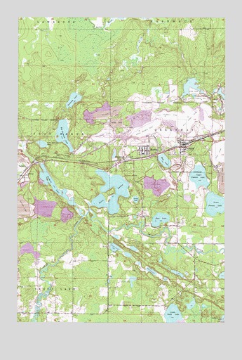
Calumet, MN USGS Topographic Map
Click on map above to begin viewing in our Map Viewer.

This topographic map contains these locations and features:
Feature Name Type Latitude Longitude GNIS ID View Map
Arcturus MineMineN47.3266°W93.3230°655150View Map
Barbara MineMineN47.3410°W93.2810°655224View Map
Bass LakeLakeN47.2924°W93.2891°655243View Map
Big Diamond LakeLakeN47.3272°W93.3474°655360View Map
CalumetPopulated PlaceN47.3219°W93.2769°655597View Map
CalumetLocaleN47.3228°W93.2728°2096572View Map
Calumet City HallBuildingN47.3186°W93.2767°2096576View Map
Calumet Community Presbyterian ChurchChurchN47.3208°W93.2750°2096573View Map
Calumet Fire DepartmentBuildingN47.3225°W93.2729°2666615View Map
Calumet LibraryBuildingN47.3186°W93.2767°2096575View Map
Calumet Post OfficePost OfficeN47.3194°W93.2767°2096574View Map
City of CalumetCivilN47.3198°W93.2666°2393500View Map
City of MarbleCivilN47.3280°W93.2941°2394999View Map
Dunning LakeLakeN47.3412°W93.3417°656071View Map
Foot LakeLakeN47.2712°W93.2942°656289View Map
Geology of the Hill Annex Mine Geological MarkerParkN47.3472°W93.2806°2096937View Map
Grace English Lutheran ChurchChurchN47.3203°W93.2956°2095410View Map
Gross -Marble MineMineN47.3299°W93.2971°656462View Map
Hill -Annex MineMineN47.3344°W93.2724°656586View Map
Hill Annex Dike OneDamN47.3066°W93.2502°1777131View Map
Hill Annex Dike ThreeDamN47.3066°W93.2519°1777133View Map
Hill Annex Pond OneReservoirN47.3066°W93.2502°1777132View Map
Hill Annex Pond ThreeReservoirN47.3066°W93.2519°1777134View Map
Hill Trumbull MineMineN47.3347°W93.2846°656591View Map
HolmanPopulated PlaceN47.3099°W93.3716°656616View Map
Holman LakeLakeN47.3061°W93.3526°656618View Map
Little Diamond LakeLakeN47.3229°W93.3603°657055View Map
Little Sand LakeLakeN47.2517°W93.2813°657124View Map
Loon LakeLakeN47.2807°W93.3164°657211View Map
Lower Panaca LakeLakeN47.2980°W93.2536°657243View Map
Majorca MineMineN47.3413°W93.2644°657286View Map
MarblePopulated PlaceN47.3205°W93.2985°657313View Map
MarbleLocaleN47.3181°W93.2958°2095413View Map
Marble Elementary SchoolSchoolN47.3194°W93.2992°2095412View Map
Marble Fire DepartmentBuildingN47.3207°W93.2999°2095416View Map
Marble Police DepartmentBuildingN47.3203°W93.2990°2095415View Map
Marble Post OfficePost OfficeN47.3207°W93.2970°2095417View Map
Marble Public LibraryBuildingN47.3208°W93.2992°2095414View Map
Mud LakeLakeN47.3163°W93.2865°657514View Map
Saint Mary's Catholic ChurchChurchN47.3208°W93.3183°2095409View Map
Sal's CampgroundLocaleN47.2633°W93.3028°2095353View Map
SilverwoodPopulated PlaceN47.3177°W93.3096°658268View Map
Spring LakeLakeN47.3005°W93.3038°658408View Map
Township of GreenwayCivilN47.3265°W93.2566°664349View Map
Twin Lake Trails Mobile Home ParkPopulated PlaceN47.3111°W93.3056°2095411View Map
Twin LakesLakeN47.2973°W93.3189°658793View Map
Upper Panaca LakeLakeN47.3099°W93.2656°658823View Map

Note: Coordinates in the location and feature list above are referenced to NAD83 datum.


Copyright (C) 2008-2025 Ryan Niemi / Sunset Dynamics ... All Rights Reserved