TopoQuest Logo
Do you find TopoQuest useful?
Help keep TopoQuest running and adding new maps/features by donating!
Bitcoin:  19c7KJd3qBynnjoSw5npx9KScwjBe4ifkT
Litecoin:  LXs6TkuXGGXo1vDsWCkWVdjQX94eUKd6ui
Home View Maps Find Maps Find Places Resources & Links


Bienville, Louisiana Topographic Map

USGS Map Title: Bienville, LA
USGS Map MRC: 32092C8
DRG (GeoTIFF) Download: o32092c8.tif


Neighboring USGS Topographic Map Quads:


  Sailes, LA  
32093D1
 

  Bryceland, LA  
32092D8
 

  Wilson Creek, LA  
32092D7
 

  Sparta, LA  
32093C1
 

  Bienville, LA  
32092C8
 

  Mount Olive, LA  
32092C7
 

  Ashland, LA  
32093B1
 

  Saline, LA  
32092B8
 

  Danville, LA  
32092B7


Map MRC Location:

N33°
W93°
N33°
W92°
H8 H7 H6 H5 H4 H3 H2 H1
G8 G7 G6 G5 G4 G3 G2 G1
F8 F7 F6 F5 F4 F3 F2 F1
E8 E7 E6 E5 E4 E3 E2 E1
D8 D7 D6 D5 D4 D3 D2 D1
C8 C7 C6 C5 C4 C3 C2 C1
B8 B7 B6 B5 B4 B3 B2 B1
A8 A7 A6 A5 A4 A3 A2 A1
N32°
W93°
N32°
W92°

Bienville, LA USGS 1:24K Topographic Map Preview:
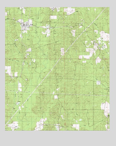
Bienville, LA USGS Topographic Map
Click on map above to begin viewing in our Map Viewer.

This topographic map contains these locations and features:
Feature Name Type Latitude Longitude GNIS ID View Map
BienvillePopulated PlaceN32.3568°W92.9804°533017View Map
Bienville Educational Center SchoolSchoolN32.3572°W92.9775°2462735View Map
Bienville High SchoolSchoolN32.3574°W92.9775°549065View Map
Bienville Parish Fire Protection Ward 7 Station 4 LuckyBuildingN32.2537°W92.9974°2673166View Map
Bienville Parish Fire Protection Ward 7 Station 8 Liberty HillBuildingN32.3338°W92.8877°2673163View Map
BlumePopulated PlaceN32.2715°W92.9904°553731View Map
Continental Lake DamDamN32.3168°W92.9718°557028View Map
Cox CrossingPopulated PlaceN32.2913°W92.8757°541078View Map
CrowsonPopulated PlaceN32.2796°W92.9846°554148View Map
Edwards Mill CreekStreamN32.2974°W92.9679°534776View Map
Elijah ChurchChurchN32.3321°W92.9304°534789View Map
Hurricane CreekStreamN32.3385°W92.9557°535871View Map
Liberty HillPopulated PlaceN32.3377°W92.8921°555037View Map
Liberty Hill CemeteryCemeteryN32.3388°W92.8929°549084View Map
Liberty Hill Gas FieldOilfieldN32.3002°W92.9043°549085View Map
Liberty Hill Missionary Baptist ChurchChurchN32.3382°W92.8929°549086View Map
LuckyPopulated PlaceN32.2552°W92.9968°541133View Map
Mount Villa ChurchChurchN32.3227°W92.9210°537417View Map
New Raspberry CemeteryCemeteryN32.3570°W92.9080°2774677View Map
Old Liberty Hill CemeteryCemeteryN32.3388°W92.8918°549094View Map
Parish Governing Authority District 7CivilN32.2801°W92.9346°1930176View Map
Pea Vine CreekStreamN32.3615°W92.9621°538028View Map
Price SchoolSchoolN32.3015°W92.9332°538400View Map
Sixmile CreekStreamN32.2596°W92.9738°539405View Map
Taylor CemeteryCemeteryN32.3499°W92.8927°539802View Map
Village of BienvilleCivilN32.3617°W92.9788°2407418View Map
Village of LuckyCivilN32.2572°W92.9967°2407494View Map
WalshPopulated PlaceN32.3710°W92.9135°543771View Map
Watts BranchStreamN32.3207°W92.9785°540266View Map

Note: Coordinates in the location and feature list above are referenced to NAD83 datum.


Copyright (C) 2008-2025 Ryan Niemi / Sunset Dynamics ... All Rights Reserved