TopoQuest Logo
Do you find TopoQuest useful?
Help keep TopoQuest running and adding new maps/features by donating!
Bitcoin:  19c7KJd3qBynnjoSw5npx9KScwjBe4ifkT
Litecoin:  LXs6TkuXGGXo1vDsWCkWVdjQX94eUKd6ui
Home View Maps Find Maps Find Places Resources & Links


Campbell Creek, South Dakota Topographic Map

USGS Map Title: Campbell Creek, SD
USGS Map MRC: 43098B7
DRG (GeoTIFF) Download: o43098b7.tif


Neighboring USGS Topographic Map Quads:


  Castalia, SD  
43098C8
 

  Bovee, SD  
43098C7
 

  Geddes, SD  
43098C6
 

  Whetstone Bay, SD  
43098B8
 

  Campbell Creek, SD  
43098B7
 

  Lake Andes NW, SD  
43098B6
 

  Bonesteel, SD  
43098A8
 

  South Scalp Creek, SD  
43098A7
 

  Lake Andes SW, SD  
43098A6


Map MRC Location:

N44°
W99°
N44°
W98°
H8 H7 H6 H5 H4 H3 H2 H1
G8 G7 G6 G5 G4 G3 G2 G1
F8 F7 F6 F5 F4 F3 F2 F1
E8 E7 E6 E5 E4 E3 E2 E1
D8 D7 D6 D5 D4 D3 D2 D1
C8 C7 C6 C5 C4 C3 C2 C1
B8 B7 B6 B5 B4 B3 B2 B1
A8 A7 A6 A5 A4 A3 A2 A1
N43°
W99°
N43°
W98°

Campbell Creek, SD USGS 1:24K Topographic Map Preview:
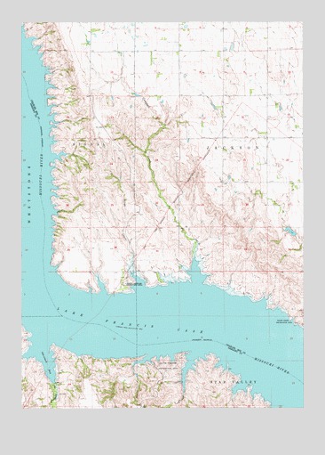
Campbell Creek, SD USGS Topographic Map
Click on map above to begin viewing in our Map Viewer.

This topographic map contains these locations and features:
Feature Name Type Latitude Longitude GNIS ID View Map
Benge CreekStreamN43.1633°W98.8223°1265121View Map
Burning Bluff (historical)CliffN43.1417°W98.8490°1259767View Map
Campbell CreekStreamN43.1656°W98.7970°1254216View Map
Dowd DamDamN43.1800°W98.7504°1260459View Map
Ducharme Cemetery (historical)CemeteryN43.1653°W98.8073°1263461View Map
Harney City (historical)LocaleN43.2125°W98.8587°1264340View Map
Jackson Number 1 School (historical)SchoolN43.1492°W98.7615°1263463View Map
Jacobson Ferry (historical)LocaleN43.1528°W98.7815°1259768View Map
Le Compte Island (historical)IslandN43.1472°W98.8179°1263584View Map
Limekiln Creek (historical)LocaleN43.1550°W98.8415°1263564View Map
Molayses Spring (historical)SpringN43.1611°W98.8679°1267087View Map
North Scalp CreekStreamN43.1339°W98.8620°1256774View Map
North Wheeler Recreation AreaParkN43.1658°W98.8256°1256789View Map
Oak Point (historical)LocaleN43.1414°W98.7912°1259769View Map
Odenbach BayBayN43.1408°W98.8637°1256833View Map
Pease Island (historical)IslandN43.1492°W98.7545°1263464View Map
Porter Landing (historical)LocaleN43.1458°W98.8715°1259766View Map
Raymond Landing (historical)LocaleN43.1514°W98.8748°1259765View Map
South Wheeler Recreation AreaParkN43.1372°W98.8093°1258224View Map
Starcher (historical)LocaleN43.1486°W98.8734°1263359View Map
Steamboat Landing (historical)LocaleN43.1589°W98.8559°1263586View Map
Stony Point (historical)CliffN43.1658°W98.8556°1263582View Map
Strine School (historical)SchoolN43.1694°W98.8054°1263460View Map
Wheeler (historical)Populated PlaceN43.1583°W98.8426°1265821View Map
Wheeler (historical)LocaleN43.1583°W98.8409°1263583View Map
Wheeler Bottoms (historical)BendN43.1528°W98.7837°1263462View Map
Wheeler BridgeBridgeN43.1547°W98.8151°1263354View Map
Whetstone Agency (historical)LocaleN43.1792°W98.8690°1263585View Map

Note: Coordinates in the location and feature list above are referenced to NAD83 datum.


Copyright (C) 2008-2025 Ryan Niemi / Sunset Dynamics ... All Rights Reserved