TopoQuest Logo
Do you find TopoQuest useful?
Help keep TopoQuest running and adding new maps/features by donating!
Bitcoin:  19c7KJd3qBynnjoSw5npx9KScwjBe4ifkT
Litecoin:  LXs6TkuXGGXo1vDsWCkWVdjQX94eUKd6ui
Home View Maps Find Maps Find Places Resources & Links


Carson, New Mexico Topographic Map

USGS Map Title: Carson, NM
USGS Map MRC: 36105C7
DRG (GeoTIFF) Download: o36105c7.tif


Neighboring USGS Topographic Map Quads:


  Servilleta Plaza, NM  
36105D8
 

  Tres Orejas, NM  
36105D7
 

  Los Cordovas, NM  
36105D6
 

  Taos Junction, NM  
36105C8
 

  Carson, NM  
36105C7
 

  Taos SW, NM  
36105C6
 

  Velarde, NM  
36105B8
 

  Trampas, NM  
36105B7
 

  Penasco, NM  
36105B6


Map MRC Location:

N37°
W106°
N37°
W105°
H8 H7 H6 H5 H4 H3 H2 H1
G8 G7 G6 G5 G4 G3 G2 G1
F8 F7 F6 F5 F4 F3 F2 F1
E8 E7 E6 E5 E4 E3 E2 E1
D8 D7 D6 D5 D4 D3 D2 D1
C8 C7 C6 C5 C4 C3 C2 C1
B8 B7 B6 B5 B4 B3 B2 B1
A8 A7 A6 A5 A4 A3 A2 A1
N36°
W106°
N36°
W105°

Carson, NM USGS 1:24K Topographic Map Preview:
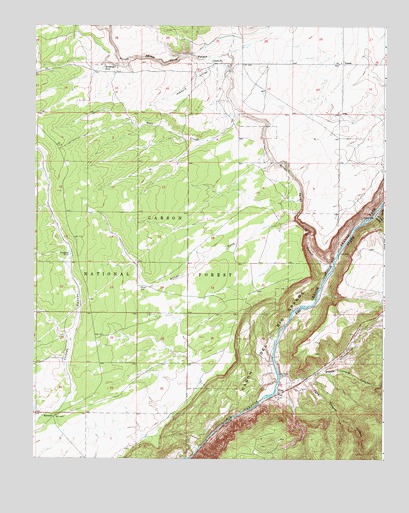
Carson, NM USGS Topographic Map
Click on map above to begin viewing in our Map Viewer.

This topographic map contains these locations and features:
Feature Name Type Latitude Longitude GNIS ID View Map
10046 Water WellWellN36.3647°W105.8006°927119View Map
Agua Caliente CanyonValleyN36.2722°W105.7775°903002View Map
Alberts Falls RapidRapidsN36.2622°W105.8033°924755View Map
Arroyo Aguaje de la PetacaStreamN36.3047°W105.7697°903353View Map
Arroyo HondoStreamN36.3211°W105.7533°928685View Map
Arroyo NoriaStreamN36.3195°W105.7820°903401View Map
Arroyo NoriaArroyoN36.3189°W105.7817°913632View Map
Ashbury ArroyoStreamN36.3636°W105.8067°903444View Map
Barnett WellWellN36.2995°W105.8372°903572View Map
BarrancaPopulated PlaceN36.2620°W105.8678°903575View Map
Bismuth ProspectMineN36.2520°W105.8131°917757View Map
Blue Feather ClaimsMineN36.3695°W105.7586°917780View Map
Bryd TankReservoirN36.2642°W105.8749°913636View Map
CarsonPopulated PlaceN36.3645°W105.7653°904813View Map
Carson Post Office (historical)Post OfficeN36.3645°W105.7653°938135View Map
Carson School Historic SiteSchoolN36.3645°W105.7658°933802View Map
Clarkson TankReservoirN36.3092°W105.8624°905189View Map
Drake RanchLocaleN36.3514°W105.8606°913634View Map
Gaging Station RapidRapidsN36.3195°W105.7561°924486View Map
Hartig TankReservoirN36.3186°W105.8405°913637View Map
Hondo CanyonValleyN36.3203°W105.7528°907060View Map
Mondragon TankReservoirN36.3633°W105.8507°908832View Map
Montosa TankReservoirN36.3649°W105.8630°913630View Map
Piedra Lumbre CanyonValleyN36.2747°W105.7728°909623View Map
PilarPopulated PlaceN36.2697°W105.7881°928772View Map
Pilar Historical MarkerParkN36.2697°W105.7881°932375View Map
Pilar Post Office (historical)Post OfficeN36.2697°W105.7881°937534View Map
Pillar ProspectsMineN36.2656°W105.7897°916664View Map
Pueblo Revolt Tricentennial Historical MarkerParkN36.2697°W105.7881°932312View Map
Rio Grande Gorge State ParkParkN36.3047°W105.7683°901471View Map
Rito CieneguillaStreamN36.2720°W105.7881°928797View Map
Sandy TankReservoirN36.3500°W105.8489°913633View Map
Scott ArroyoStreamN36.3495°W105.8008°910884View Map
Section Thirty-five TankReservoirN36.3586°W105.8486°913631View Map
The Karmic Wave RapidRapidsN36.2675°W105.7933°924515View Map
The Narrows RapidRapidsN36.2622°W105.8111°924525View Map
Tierra Amarilla CanyonValleyN36.2745°W105.7695°911698View Map
Vasquez de Coronados Route Historical MarkerParkN36.2697°W105.7881°932230View Map

Note: Coordinates in the location and feature list above are referenced to NAD83 datum.


Copyright (C) 2008-2025 Ryan Niemi / Sunset Dynamics ... All Rights Reserved