TopoQuest Logo
Do you find TopoQuest useful?
Help keep TopoQuest running and adding new maps/features by donating!
Bitcoin:  19c7KJd3qBynnjoSw5npx9KScwjBe4ifkT
Litecoin:  LXs6TkuXGGXo1vDsWCkWVdjQX94eUKd6ui
Home View Maps Find Maps Find Places Resources & Links


Cerro Parido, New Mexico Topographic Map

USGS Map Title: Cerro Parido, NM
USGS Map MRC: 35107E3
DRG (GeoTIFF) Download: o35107e3.tif


Neighboring USGS Topographic Map Quads:


  Mesita Del Gavilan, NM  
35107F4
 

  Canada Calladita, NM  
35107F3
 

  Arroyo Empedrado, NM  
35107F2
 

  Mesa Cortada, NM  
35107E4
 

  Cerro Parido, NM  
35107E3
 

  Guadalupe, NM  
35107E2
 

  El Dado Mesa, NM  
35107D4
 

  Laguna Seca, NM  
35107D3
 

  Cerro Tinaja, NM  
35107D2


Map MRC Location:

N36°
W108°
N36°
W107°
H8 H7 H6 H5 H4 H3 H2 H1
G8 G7 G6 G5 G4 G3 G2 G1
F8 F7 F6 F5 F4 F3 F2 F1
E8 E7 E6 E5 E4 E3 E2 E1
D8 D7 D6 D5 D4 D3 D2 D1
C8 C7 C6 C5 C4 C3 C2 C1
B8 B7 B6 B5 B4 B3 B2 B1
A8 A7 A6 A5 A4 A3 A2 A1
N35°
W108°
N35°
W107°

Cerro Parido, NM USGS 1:24K Topographic Map Preview:
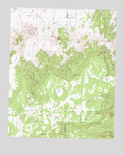
Cerro Parido, NM USGS Topographic Map
Click on map above to begin viewing in our Map Viewer.

This topographic map contains these locations and features:
Feature Name Type Latitude Longitude GNIS ID View Map
10017 Water WellWellN35.6103°W107.2917°921894View Map
Barrel SpringSpringN35.5713°W107.2516°903586View Map
Bear MouthSummitN35.5848°W107.2650°903665View Map
Cerrito del RelampagoSummitN35.5048°W107.3314°904908View Map
Cerro ParidoSummitN35.5956°W107.3184°904985View Map
Cerro PelonSummitN35.5931°W107.2950°904991View Map
Coal SpringSpringN35.6225°W107.3503°905224View Map
El BanquitoBenchN35.5709°W107.3695°906032View Map
Ernest Montoya RanchLocaleN35.6161°W107.3070°906180View Map
Heifer TankReservoirN35.5376°W107.3491°906900View Map
Ignacio Chavez GrantCivilN35.5592°W107.3348°907184View Map
Joe Montoya RanchLocaleN35.6114°W107.3239°907384View Map
Laguna BlancaLakeN35.5201°W107.3209°907761View Map
Laguna CuarentaLakeN35.5184°W107.2869°907773View Map
Mesa la AzabacheSummitN35.6006°W107.3520°908586View Map
Ned TankLakeN35.5569°W107.2605°909034View Map
Ojo AzabacheSpringN35.6174°W107.3511°909307View Map
Ojo de AlamoSpringN35.5942°W107.2581°909292View Map
R-13 Water WellWellN35.5917°W107.3437°921782View Map
Rincon EntranosaValleyN35.5986°W107.3353°910196View Map
Salado SpringSpringN35.5051°W107.2682°937132View Map
Sandoval RanchLocaleN35.6239°W107.3712°910757View Map
Seco TankReservoirN35.5451°W107.3162°910904View Map
Toro TankReservoirN35.5367°W107.2832°911754View Map
Toruno SpringSpringN35.5654°W107.3142°911763View Map

Note: Coordinates in the location and feature list above are referenced to NAD83 datum.


Copyright (C) 2008-2025 Ryan Niemi / Sunset Dynamics ... All Rights Reserved