TopoQuest Logo
Do you find TopoQuest useful?
Help keep TopoQuest running and adding new maps/features by donating!
Bitcoin:  19c7KJd3qBynnjoSw5npx9KScwjBe4ifkT
Litecoin:  LXs6TkuXGGXo1vDsWCkWVdjQX94eUKd6ui
Home View Maps Find Maps Find Places Resources & Links


Chain of Ponds, Maine Topographic Map

USGS Map Title: Chain of Ponds, ME
USGS Map MRC: 45070C6
DRG (GeoTIFF) Download: o45070c6.tif


Neighboring USGS Topographic Map Quads:


  Louise Mountain, ME  
45070D7
 

  Merrill Mountain, ME  
45070D6
 

  Kibby Mountain, ME  
45070D5
 

  Northwest Pond, ME  
45070C7
 

  Chain of Ponds, ME  
45070C6
 

  Jim Pond, ME  
45070C5
 

  Little Kennebago Lake, ME  
45070B7
 

  Black Mountain, ME  
45070B6
 

  Tim Mountain, ME  
45070B5


Map MRC Location:

N46°
W71°
N46°
W70°
H8 H7 H6 H5 H4 H3 H2 H1
G8 G7 G6 G5 G4 G3 G2 G1
F8 F7 F6 F5 F4 F3 F2 F1
E8 E7 E6 E5 E4 E3 E2 E1
D8 D7 D6 D5 D4 D3 D2 D1
C8 C7 C6 C5 C4 C3 C2 C1
B8 B7 B6 B5 B4 B3 B2 B1
A8 A7 A6 A5 A4 A3 A2 A1
N45°
W71°
N45°
W70°

Chain of Ponds, ME USGS 1:24K Topographic Map Preview:
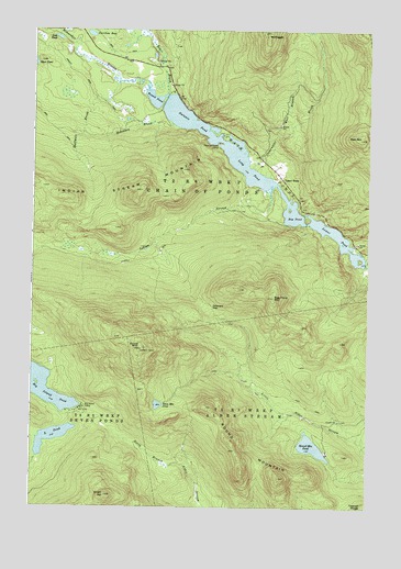
Chain of Ponds, ME USGS Topographic Map
Click on map above to begin viewing in our Map Viewer.

This topographic map contains these locations and features:
Feature Name Type Latitude Longitude GNIS ID View Map
Alder Stream TownshipCivilN45.2631°W70.6413°2748767View Map
Arnold Pond TrailTrailN45.3623°W70.7320°561298View Map
Bag PondLakeN45.3267°W70.6534°561429View Map
Bag Pond MountainSummitN45.3050°W70.6603°561430View Map
Bear BrookStreamN45.3584°W70.6995°561821View Map
Big Island CampLocaleN45.2762°W70.7315°562195View Map
Big Island PondLakeN45.2820°W70.7487°562196View Map
Caribou BogLakeN45.3739°W70.7288°563513View Map
Chain LakesReservoirN45.3134°W70.6262°1773748View Map
Chain Lakes DamDamN45.3136°W70.6262°1773747View Map
Chain of PondsLakeN45.3392°W70.6707°563788View Map
Chain of Ponds CampLocaleN45.3453°W70.6806°563789View Map
Chain of Ponds TownshipCivilN45.3484°W70.6947°2748764View Map
Clearwater BrookStreamN45.3409°W70.6706°564078View Map
Delaware GapGapN45.3014°W70.6834°565018View Map
Halfmile BrookStreamN45.3609°W70.7195°567456View Map
Horseshoe StreamStreamN45.3592°W70.7078°568330View Map
Indian StreamStreamN45.3339°W70.6617°568613View Map
Indian Stream MountainSummitN45.3314°W70.7128°568619View Map
L PondLakeN45.2682°W70.7418°569281View Map
Long PondLakeN45.3384°W70.6715°570288View Map
Lost PondLakeN45.3729°W70.7408°570405View Map
Lower PondReservoirN45.3136°W70.6262°570533View Map
Morrell TrailTrailN45.3150°W70.7084°571671View Map
Mount PisgahSummitN45.3730°W70.6630°573451View Map
Natanis PondLakeN45.3506°W70.6926°572071View Map
Onion HillSummitN45.2531°W70.7218°572749View Map
Robinson BrookStreamN45.3503°W70.7001°574317View Map
Round MountainSummitN45.2761°W70.6845°574483View Map
Round MountainPopulated PlaceN45.2642°W70.6395°1908418View Map
Round Mountain PondLakeN45.2661°W70.6455°574485View Map
Round PondLakeN45.3567°W70.7053°574510View Map
Sisk MountainSummitN45.3467°W70.6282°575497View Map
Snow MountainSummitN45.2914°W70.7093°575684View Map
Snow Mountain PondLakeN45.2767°W70.7026°575687View Map
Unorganized Territory of North FranklinCivilN45.2996°W70.6435°582632View Map
Upper FarmLocaleN45.3362°W70.6581°577604View Map
West Branch Clearwater BrookStreamN45.3475°W70.6606°578044View Map

Note: Coordinates in the location and feature list above are referenced to NAD83 datum.


Copyright (C) 2008-2025 Ryan Niemi / Sunset Dynamics ... All Rights Reserved