TopoQuest Logo
Do you find TopoQuest useful?
Help keep TopoQuest running and adding new maps/features by donating!
Bitcoin:  19c7KJd3qBynnjoSw5npx9KScwjBe4ifkT
Litecoin:  LXs6TkuXGGXo1vDsWCkWVdjQX94eUKd6ui
Home View Maps Find Maps Find Places Resources & Links


Dardanelles Cone, California Topographic Map

USGS Map Title: Dardanelles Cone, CA
USGS Map MRC: 38119D7
DRG (GeoTIFF) Download: o38119d7.tif


Neighboring USGS Topographic Map Quads:


  Pacific Valley, CA  
38119E8
 

  Ebbetts Pass, CA  
38119E7
 

  Wolf Creek, CA  
38119E6
 

  Spicer Meadow Reservoir, CA  
38119D8
 

  Dardanelles Cone, CA  
38119D7
 

  Disaster Peak, CA  
38119D6
 

  Donnell Lake, CA  
38119C8
 

  Dardanelle, CA  
38119C7
 

  Sonora Pass, CA  
38119C6


Map MRC Location:

N39°
W120°
N39°
W119°
H8 H7 H6 H5 H4 H3 H2 H1
G8 G7 G6 G5 G4 G3 G2 G1
F8 F7 F6 F5 F4 F3 F2 F1
E8 E7 E6 E5 E4 E3 E2 E1
D8 D7 D6 D5 D4 D3 D2 D1
C8 C7 C6 C5 C4 C3 C2 C1
B8 B7 B6 B5 B4 B3 B2 B1
A8 A7 A6 A5 A4 A3 A2 A1
N38°
W120°
N38°
W119°

Dardanelles Cone, CA USGS 1:24K Topographic Map Preview:
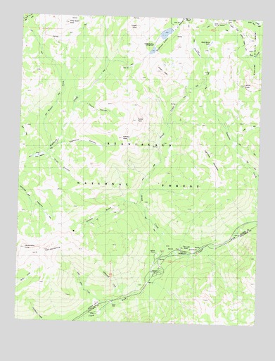
Dardanelles Cone, CA USGS Topographic Map
Click on map above to begin viewing in our Map Viewer.

This topographic map contains these locations and features:
Feature Name Type Latitude Longitude GNIS ID View Map
Adams CampLocaleN38.4505°W119.7649°1662364View Map
Airola PeakSummitN38.4577°W119.8149°256143View Map
Arnot Branch Campground (historical)LocaleN38.4021°W119.7991°1667827View Map
Arnot CreekStreamN38.4019°W119.7993°256326View Map
Arnot PeakSummitN38.4730°W119.7596°256327View Map
Bear Tree MeadowFlatN38.4994°W119.7941°256711View Map
Champion CanyonValleyN38.4471°W119.8566°258190View Map
Clark Fork CampgroundLocaleN38.3963°W119.8010°266569View Map
Clarkfork Horse CampLocaleN38.4010°W119.7941°274768View Map
Cottonwood Campground (historical)LocaleN38.3827°W119.8257°1667838View Map
Cottonwood CreekStreamN38.3824°W119.8252°254784View Map
Cottonwood Picnic AreaLocaleN38.3824°W119.8241°274767View Map
Dardanelles ConeSummitN38.4046°W119.8718°222012View Map
Del Rio Camp GSALocaleN38.4066°W119.7941°1662363View Map
Disaster CreekStreamN38.4174°W119.7507°253682View Map
Folger PeakSummitN38.4957°W119.8155°1656021View Map
Half Moon LakeLakeN38.4904°W119.7773°224792View Map
Highland LakesLakeN38.4935°W119.8011°225292View Map
Highland Lakes CampgroundLocaleN38.4885°W119.8068°225294View Map
Hiram CanyonValleyN38.4430°W119.8621°225363View Map
Hiram MeadowFlatN38.4421°W119.8660°225365View Map
Hiram PeakSummitN38.4780°W119.8030°225366View Map
Iceberg PeakSummitN38.4502°W119.8224°225820View Map
Liahona CampLocaleN38.4032°W119.8032°227055View Map
Lightning MountianSummitN38.4485°W119.7827°253268View Map
Little Teton CreekStreamN38.3802°W119.8296°227388View Map
Lower Gardner MeadowFlatN38.4985°W119.7768°227770View Map
Lower Highland DamDamN38.4949°W119.7977°1664714View Map
Peaceful PinesPopulated PlaceN38.4060°W119.7893°1656212View Map
Peaceful Pines CampgroundLocaleN38.4063°W119.7796°1733671View Map
Peep SightArchN38.4931°W119.8558°2709986View Map
Peep Sight PeakSummitN38.4971°W119.8516°230466View Map
Poison CanyonValleyN38.4627°W119.8474°1654930View Map
Riverview Campground (historical)LocaleN38.3985°W119.8043°1667832View Map
Sand FlatFlatN38.4046°W119.7943°232496View Map
Sand Flat CampgroundLocaleN38.4038°W119.7868°232498View Map
Sequoia Camp GSALocaleN38.4046°W119.8005°1662368View Map
The DardanellesSummitN38.4046°W119.8630°255131View Map
Upper Gardner MeadowFlatN38.4857°W119.7849°236886View Map
Weiser CreekStreamN38.4455°W119.8602°237403View Map
Wolf Creek PassGapN38.4988°W119.7699°238092View Map
Woods GulchValleyN38.4224°W119.8110°238158View Map

Note: Coordinates in the location and feature list above are referenced to NAD83 datum.


Copyright (C) 2008-2024 Ryan Niemi / Sunset Dynamics ... All Rights Reserved