TopoQuest Logo
Do you find TopoQuest useful?
Help keep TopoQuest running and adding new maps/features by donating!
Bitcoin:  19c7KJd3qBynnjoSw5npx9KScwjBe4ifkT
Litecoin:  LXs6TkuXGGXo1vDsWCkWVdjQX94eUKd6ui
Home View Maps Find Maps Find Places Resources & Links


Edna Hill, Texas Topographic Map

USGS Map Title: Edna Hill, TX
USGS Map MRC: 31098H3
DRG (GeoTIFF) Download: o31098h3.tif


Neighboring USGS Topographic Map Quads:


  Comyn, TX  
32098A4
 

  Dublin, TX  
32098A3
 

  Alexander, TX  
32098A2
 

  Proctor, TX  
31098H4
 

  Edna Hill, TX  
31098H3
 

  Carlton, TX  
31098H2
 

  Gustine, TX  
31098G4
 

  Lamkin, TX  
31098G3
 

  Gentrys Mill, TX  
31098G2


Map MRC Location:

N32°
W99°
N32°
W98°
H8 H7 H6 H5 H4 H3 H2 H1
G8 G7 G6 G5 G4 G3 G2 G1
F8 F7 F6 F5 F4 F3 F2 F1
E8 E7 E6 E5 E4 E3 E2 E1
D8 D7 D6 D5 D4 D3 D2 D1
C8 C7 C6 C5 C4 C3 C2 C1
B8 B7 B6 B5 B4 B3 B2 B1
A8 A7 A6 A5 A4 A3 A2 A1
N31°
W99°
N31°
W98°

Edna Hill, TX USGS 1:24K Topographic Map Preview:
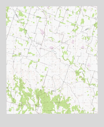
Edna Hill, TX USGS Topographic Map
Click on map above to begin viewing in our Map Viewer.

This topographic map contains these locations and features:
Feature Name Type Latitude Longitude GNIS ID View Map
Barbee CemeteryCemeteryN31.9874°W98.3292°1330022View Map
Dry Joplin CreekStreamN31.8801°W98.3567°1334700View Map
Edna HillPopulated PlaceN31.9565°W98.3303°1378242View Map
Fourmile CreekStreamN31.9157°W98.2645°1336117View Map
HazeldellPopulated PlaceN31.8815°W98.3320°1378432View Map
Lightning C RanchLocaleN31.9015°W98.3095°1339917View Map
Long BranchStreamN31.9413°W98.2970°1340421View Map
Pecan CemeteryCemeteryN31.9854°W98.2537°1343757View Map
Salt BranchStreamN31.9332°W98.2825°1346208View Map
Sand MountainSummitN31.9454°W98.3559°1346528View Map
Sawyer BranchStreamN31.9946°W98.3198°1346741View Map
Soil Conservation Service Site 18 DamDamN31.9985°W98.3137°1855893View Map
Soil Conservation Service Site 18 ReservoirReservoirN31.9985°W98.3122°1855894View Map
Soil Conservation Service Site 19 DamDamN31.9668°W98.3237°1855895View Map
Soil Conservation Service Site 19 ReservoirReservoirN31.9668°W98.3237°1855896View Map
Soil Conservation Service Site 20 DamDamN31.9485°W98.3120°1861167View Map
Soil Conservation Service Site 20 ReservoirReservoirN31.9485°W98.3120°1861168View Map
Soil Conservation Service Site 21 DamDamN31.9568°W98.2837°1861165View Map
Soil Conservation Service Site 21 ReservoirReservoirN31.9589°W98.2842°1861166View Map
Soil Conservation Service Site 22 DamDamN31.9501°W98.2720°1861163View Map
Soil Conservation Service Site 22 ReservoirReservoirN31.9501°W98.2720°1861164View Map
Soil Conservation Service Site 23 DamDamN31.9301°W98.2637°1861161View Map
Soil Conservation Service Site 23 ReservoirReservoirN31.9320°W98.2625°1861162View Map
WilsonPopulated PlaceN31.9315°W98.2670°1379282View Map

Note: Coordinates in the location and feature list above are referenced to NAD83 datum.


Copyright (C) 2008-2025 Ryan Niemi / Sunset Dynamics ... All Rights Reserved