TopoQuest Logo
Do you find TopoQuest useful?
Help keep TopoQuest running and adding new maps/features by donating!
Bitcoin:  19c7KJd3qBynnjoSw5npx9KScwjBe4ifkT
Litecoin:  LXs6TkuXGGXo1vDsWCkWVdjQX94eUKd6ui
Home View Maps Find Maps Find Places Resources & Links


Elizabethtown, Pennsylvania Topographic Map

USGS Map Title: Elizabethtown, PA
USGS Map MRC: 40076B5
DRG (GeoTIFF) Download: o40076b5.tif


Neighboring USGS Topographic Map Quads:


  Hershey, PA  
40076C6
 

  Palmyra, PA  
40076C5
 

  Lebanon, PA  
40076C4
 

  Middletown, PA  
40076B6
 

  Elizabethtown, PA  
40076B5
 

  Manheim, PA  
40076B4
 

  York Haven, PA  
40076A6
 

  Columbia West, PA  
40076A5
 

  Columbia East, PA  
40076A4


Map MRC Location:

N41°
W77°
N41°
W76°
H8 H7 H6 H5 H4 H3 H2 H1
G8 G7 G6 G5 G4 G3 G2 G1
F8 F7 F6 F5 F4 F3 F2 F1
E8 E7 E6 E5 E4 E3 E2 E1
D8 D7 D6 D5 D4 D3 D2 D1
C8 C7 C6 C5 C4 C3 C2 C1
B8 B7 B6 B5 B4 B3 B2 B1
A8 A7 A6 A5 A4 A3 A2 A1
N40°
W77°
N40°
W76°

Elizabethtown, PA USGS 1:24K Topographic Map Preview:
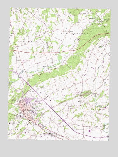
Elizabethtown, PA USGS Topographic Map
Click on map above to begin viewing in our Map Viewer.

This topographic map contains these locations and features:
Feature Name Type Latitude Longitude GNIS ID View Map
AberdeenPopulated PlaceN40.1768°W76.6233°1168026View Map
Alliance ChurchChurchN40.1529°W76.6027°1168204View Map
AnchorPopulated PlaceN40.1373°W76.5814°1168278View Map
BachmanvillePopulated PlaceN40.2426°W76.5947°1168555View Map
BellairePopulated PlaceN40.1915°W76.5750°1169157View Map
BeverlyPopulated PlaceN40.1829°W76.6116°1203084View Map
Borough of ElizabethtownCivilN40.1533°W76.5991°1215337View Map
Brubaker RunStreamN40.1590°W76.5011°1170424View Map
Chickies ChurchChurchN40.1831°W76.5069°1171771View Map
Chickies Creek FarmLocaleN40.1561°W76.5050°2677359View Map
Cloverleaf Herb FarmLocaleN40.1544°W76.5483°2677358View Map
ColebrookPopulated PlaceN40.2381°W76.5111°1172180View Map
Colebrook ChurchChurchN40.2370°W76.5408°1198591View Map
Conewago Church Number 1ChurchN40.2415°W76.5972°1172314View Map
Conewago Church Number 2ChurchN40.1998°W76.6147°1172315View Map
Conewago Elementary SchoolSchoolN40.2243°W76.6202°1213827View Map
DeodatePopulated PlaceN40.2134°W76.6214°1173170View Map
Dinosaur RockPillarN40.2284°W76.5055°1202167View Map
East High State SchoolSchoolN40.1590°W76.5875°1173820View Map
East High Street Elementary SchoolSchoolN40.1593°W76.5877°1213940View Map
Eilzabethtown Borough Wastewater Treatment PlantBuildingN40.1298°W76.6250°2054316View Map
ElizabethtownPopulated PlaceN40.1529°W76.6027°1174103View Map
Elizabethtown Borough ParkParkN40.1518°W76.5972°1198040View Map
Elizabethtown CollegeSchoolN40.1493°W76.5930°1174104View Map
Elizabethtown Fire Department Station 74BuildingN40.1559°W76.6002°2100292View Map
Elizabethtown Junior Senior High SchoolSchoolN40.1559°W76.5944°1211659View Map
Elizabethtown Middle SchoolSchoolN40.1559°W76.5944°1211660View Map
Elizabethtown Police DepartmentBuildingN40.1456°W76.5998°2780165View Map
Elizabethtown Post OfficePost OfficeN40.1495°W76.6043°2779736View Map
Elizabethtown State HospitalHospitalN40.1623°W76.6189°1212497View Map
Esbenshade FarmsLocaleN40.1339°W76.5236°2677355View Map
Fairview Elementary SchoolSchoolN40.1729°W76.5575°1213842View Map
Gallagher RunStreamN40.1898°W76.6083°2057028View Map
Hoffer CreekStreamN40.1898°W76.6036°1192618View Map
LawnPopulated PlaceN40.2201°W76.5391°1179046View Map
Lawn Fire Company and Ambulance Station 3BuildingN40.2183°W76.5406°2653157View Map
Lawn Post OfficePost OfficeN40.2199°W76.5403°2779725View Map
Lawn SchoolSchoolN40.2251°W76.5452°1179049View Map
Little Conewago CreekStreamN40.2140°W76.5597°1192798View Map
Masonic SchoolSchoolN40.1307°W76.6180°1180531View Map
Mill Road Elementary SchoolSchoolN40.1604°W76.6117°1213882View Map
Milton GrovePopulated PlaceN40.1623°W76.5316°1181299View Map
Milton Grove CemeteryCemeteryN40.1681°W76.5364°1181300View Map
Mount Calvary ChurchChurchN40.1640°W76.6055°1181651View Map
Mount Joy Township Forest Fire Crew Station 93BuildingN40.1562°W76.5497°2652743View Map
Mount Pleasant ChurchChurchN40.1376°W76.5147°1181812View Map
Mount Tunnel CemeteryCemeteryN40.1423°W76.5961°1181864View Map
Moyer CemeteryCemeteryN40.2279°W76.5786°1181989View Map
Northwest Emergency Medical Services Elizabethtown Station 86BuildingN40.1443°W76.6085°2722338View Map
Northwest Regional Police DepartmentBuildingN40.1453°W76.5596°2780138View Map
Oberholtzer CemeteryCemeteryN40.1743°W76.5816°1182857View Map
RheemsPopulated PlaceN40.1301°W76.5705°1184976View Map
Rheems Census Designated PlaceCensusN40.1256°W76.5734°2389746View Map
Rheems Elementary SchoolSchoolN40.1279°W76.5708°1211745View Map
Rheems Fire Company 1 Station 70BuildingN40.1324°W76.5816°2100331View Map
Rheems Post OfficePost OfficeN40.1291°W76.5707°2779911View Map
Rheems QuarryMineN40.1294°W76.5789°1207143View Map
Rissers ChurchChurchN40.1784°W76.5425°1185110View Map
Saint Pauls ChurchChurchN40.1581°W76.6044°1186586View Map
Schenks ChurchChurchN40.2229°W76.6214°1187078View Map
Shells RunStreamN40.1726°W76.5214°1212496View Map
State Game Lands Number 145ParkN40.2301°W76.5114°1193436View Map
Stauffers ChurchChurchN40.2498°W76.6055°1188570View Map
Sunny Hill FarmLocaleN40.1692°W76.5153°2711183View Map
Township of ConewagoCivilN40.2153°W76.6160°1216353View Map
Township of Mount JoyCivilN40.1667°W76.5483°1216637View Map
Township of South LondonderryCivilN40.2424°W76.5432°1216683View Map
Township of West DonegalCivilN40.1297°W76.6227°1216649View Map
Upper LawnPopulated PlaceN40.2284°W76.5514°1190237View Map
West Greentree ChurchChurchN40.1568°W76.5502°1191035View Map
WPDC-AM (Elizabethtown)TowerN40.1712°W76.5969°1200378View Map
WRKZ-FM (Elizabethtown)TowerN40.1712°W76.5969°1200196View Map

Note: Coordinates in the location and feature list above are referenced to NAD83 datum.


Copyright (C) 2008-2025 Ryan Niemi / Sunset Dynamics ... All Rights Reserved