TopoQuest Logo
Do you find TopoQuest useful?
Help keep TopoQuest running and adding new maps/features by donating!
Bitcoin:  19c7KJd3qBynnjoSw5npx9KScwjBe4ifkT
Litecoin:  LXs6TkuXGGXo1vDsWCkWVdjQX94eUKd6ui
Home View Maps Find Maps Find Places Resources & Links


Canada Ojitos, New Mexico Topographic Map

USGS Map Title: Canada Ojitos, NM
USGS Map MRC: 36106D8
DRG (GeoTIFF) Download: o36106d8.tif


Neighboring USGS Topographic Map Quads:


  Leavry Canyon, NM  
36107E1
 

  Los Indios Canyon, NM  
36106E8
 

  Pounds Mesa, NM  
36106E7
 

  Ojito, NM  
36107D1
 

  Canada Ojitos, NM  
36106D8
 

  Llaves, NM  
36106D7
 

  Lindrith, NM  
36107C1
 

  Laguna Gurule, NM  
36106C8
 

  French Mesa, NM  
36106C7


Map MRC Location:

N37°
W107°
N37°
W106°
H8 H7 H6 H5 H4 H3 H2 H1
G8 G7 G6 G5 G4 G3 G2 G1
F8 F7 F6 F5 F4 F3 F2 F1
E8 E7 E6 E5 E4 E3 E2 E1
D8 D7 D6 D5 D4 D3 D2 D1
C8 C7 C6 C5 C4 C3 C2 C1
B8 B7 B6 B5 B4 B3 B2 B1
A8 A7 A6 A5 A4 A3 A2 A1
N36°
W107°
N36°
W106°

Canada Ojitos, NM USGS 1:24K Topographic Map Preview:
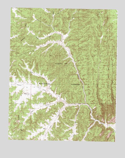
Canada Ojitos, NM USGS Topographic Map
Click on map above to begin viewing in our Map Viewer.

This topographic map contains these locations and features:
Feature Name Type Latitude Longitude GNIS ID View Map
Bond CanyonValleyN36.4853°W106.9506°912568View Map
Boot Jack CanyonValleyN36.4925°W106.9489°904010View Map
Caņada GuruleValleyN36.3947°W106.8981°904456View Map
Caņada Jesus MoyaValleyN36.4095°W106.9164°904462View Map
Caņada JoseValleyN36.4770°W106.9467°904463View Map
Caņada OjitosValleyN36.4100°W106.9098°904475View Map
Caņada SimonValleyN36.4114°W106.9356°904483View Map
Caņada TanquesValleyN36.4122°W106.9423°904487View Map
Collins RanchLocaleN36.4253°W106.9661°905261View Map
Corral CanyonValleyN36.3900°W106.8864°905367View Map
Corral TankReservoirN36.4636°W106.8936°936792View Map
Deer RunStreamN36.4714°W106.9389°905704View Map
Fence TankReservoirN36.4120°W106.9908°899320View Map
Horse Heaven CanyonValleyN36.3883°W106.8862°912590View Map
Laguna SecaLakeN36.4187°W106.9785°907799View Map
Laguna SimonReservoirN36.3862°W106.9568°907805View Map
Lang CanyonValleyN36.4861°W106.9620°2038799View Map
Largo SpringSpringN36.4989°W106.9920°936791View Map
Nogales Cliff HouseLocaleN36.4131°W106.8864°1968057View Map
Pasture CanyonValleyN36.4222°W106.9553°909490View Map
Pasture TankReservoirN36.4395°W106.9737°936793View Map
Rodent TankReservoirN36.4132°W106.9840°899321View Map
Spruce CanyonValleyN36.4953°W106.9539°899317View Map
Syphers RanchLocaleN36.4550°W106.9303°911515View Map
Tanques Water WellWellN36.4004°W106.9730°926472View Map
Wolf DrawValleyN36.4661°W106.9400°912477View Map
Young ProspectMineN36.3814°W106.9962°917004View Map

Note: Coordinates in the location and feature list above are referenced to NAD83 datum.


Copyright (C) 2008-2025 Ryan Niemi / Sunset Dynamics ... All Rights Reserved