TopoQuest Logo
Do you find TopoQuest useful?
Help keep TopoQuest running and adding new maps/features by donating!
Bitcoin:  19c7KJd3qBynnjoSw5npx9KScwjBe4ifkT
Litecoin:  LXs6TkuXGGXo1vDsWCkWVdjQX94eUKd6ui
Home View Maps Find Maps Find Places Resources & Links


Canadian West, Texas Topographic Map

USGS Map Title: Canadian West, TX
USGS Map MRC: 35100H4
DRG (GeoTIFF) Download: o35100h4.tif


Neighboring USGS Topographic Map Quads:


  Barton Creek, TX  
36100A5
 

  Lipscomb SW, TX  
36100A4
 

  Glazier, TX  
36100A3
 

  East Dry Creek, TX  
35100H5
 

  Canadian West, TX  
35100H4
 

  Canadian East, TX  
35100H3
 

  Washburn Arroyo, TX  
35100G5
 

  Mendota, TX  
35100G4
 

  Canadian SE, TX  
35100G3


Map MRC Location:

N36°
W101°
N36°
W100°
H8 H7 H6 H5 H4 H3 H2 H1
G8 G7 G6 G5 G4 G3 G2 G1
F8 F7 F6 F5 F4 F3 F2 F1
E8 E7 E6 E5 E4 E3 E2 E1
D8 D7 D6 D5 D4 D3 D2 D1
C8 C7 C6 C5 C4 C3 C2 C1
B8 B7 B6 B5 B4 B3 B2 B1
A8 A7 A6 A5 A4 A3 A2 A1
N35°
W101°
N35°
W100°

Canadian West, TX USGS 1:24K Topographic Map Preview:
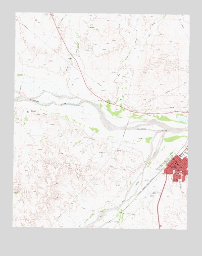
Canadian West, TX USGS Topographic Map
Click on map above to begin viewing in our Map Viewer.

This topographic map contains these locations and features:
Feature Name Type Latitude Longitude GNIS ID View Map
Abundant Life Assembly of God ChurchChurchN35.9042°W100.3893°2021026View Map
Baker Elementary SchoolSchoolN35.9084°W100.3826°2006640View Map
Baker SchoolSchoolN35.9078°W100.3824°1372373View Map
Believers Covenant Fellowship ChurchChurchN35.9075°W100.3901°2021032View Map
Big Timber CreekStreamN35.9375°W100.4118°1372570View Map
CanadianPopulated PlaceN35.9128°W100.3821°1372905View Map
Canadian Alterative SchoolSchoolN35.9084°W100.3826°2006641View Map
Canadian City HallBuildingN35.9155°W100.3864°2753381View Map
Canadian Elementary SchoolSchoolN35.9013°W100.3858°2006642View Map
Canadian High SchoolSchoolN35.9089°W100.3852°2006643View Map
Canadian Middle SchoolSchoolN35.9092°W100.3842°2006644View Map
Canadian North DivisionCivilN35.9378°W100.4356°1938596View Map
Canadian Post OfficePost OfficeN35.9134°W100.3843°2731320View Map
Canadian Volunteer Fire DepartmentBuildingN35.9160°W100.3858°2551944View Map
Catholic ChurchChurchN35.9117°W100.3785°2021029View Map
Central Baptist ChurchChurchN35.9123°W100.3812°2021027View Map
City of CanadianCivilN35.9097°W100.3839°2409973View Map
East Prong Big Timber CreekStreamN35.9800°W100.4090°1373560View Map
First Baptist ChurchChurchN35.9117°W100.3804°2021028View Map
First Presbyterian ChurchChurchN35.9117°W100.3824°2021031View Map
Hemphill County AirportAirportN35.8954°W100.4011°1386336View Map
Hemphill County Emergency Medical ServicesBuildingN35.9041°W100.3877°2655994View Map
Hemphill County HospitalHospitalN35.9036°W100.3881°2015777View Map
Hemphill County JailBuildingN35.9126°W100.3830°2738801View Map
Hemphill County Sheriff's OfficeBuildingN35.9125°W100.3831°2750506View Map
Horse CreekStreamN35.9520°W100.4574°1374142View Map
Methodist ChurchChurchN35.9128°W100.3818°2021030View Map
Palace TheatreBuildingN35.9143°W100.3847°2741715View Map
Red Deer CreekStreamN35.9317°W100.3918°1375668View Map
River Valley Pioneer MuseumBuildingN35.9153°W100.3843°2014601View Map
West Horse CreekStreamN35.9984°W100.4615°1376710View Map

Note: Coordinates in the location and feature list above are referenced to NAD83 datum.


Copyright (C) 2008-2025 Ryan Niemi / Sunset Dynamics ... All Rights Reserved