TopoQuest Logo
Do you find TopoQuest useful?
Help keep TopoQuest running and adding new maps/features by donating!
Bitcoin:  19c7KJd3qBynnjoSw5npx9KScwjBe4ifkT
Litecoin:  LXs6TkuXGGXo1vDsWCkWVdjQX94eUKd6ui
Home View Maps Find Maps Find Places Resources & Links


Great Cacapon, West Virginia Topographic Map

USGS Map Title: Great Cacapon, WV
USGS Map MRC: 39078E3
DRG (GeoTIFF) Download: o39078e3.tif


Neighboring USGS Topographic Map Quads:


  Artemas, PA  
39078F4
 

  Bellegrove, MD  
39078F3
 

  Hancock, MD  
39078F2
 

  Paw Paw, WV  
39078E4
 

  Great Cacapon, WV  
39078E3
 

  Stotlers Crossroads, WV  
39078E2
 

  Largent, WV  
39078D4
 

  Ridge, WV  
39078D3
 

  Glengary, WV  
39078D2


Map MRC Location:

N40°
W79°
N40°
W78°
H8 H7 H6 H5 H4 H3 H2 H1
G8 G7 G6 G5 G4 G3 G2 G1
F8 F7 F6 F5 F4 F3 F2 F1
E8 E7 E6 E5 E4 E3 E2 E1
D8 D7 D6 D5 D4 D3 D2 D1
C8 C7 C6 C5 C4 C3 C2 C1
B8 B7 B6 B5 B4 B3 B2 B1
A8 A7 A6 A5 A4 A3 A2 A1
N39°
W79°
N39°
W78°

Great Cacapon, WV USGS 1:24K Topographic Map Preview:
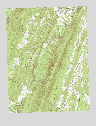
Great Cacapon, WV USGS Topographic Map
Click on map above to begin viewing in our Map Viewer.

This topographic map contains these locations and features:
Feature Name Type Latitude Longitude GNIS ID View Map
Bare RidgeRidgeN39.5620°W78.3526°1535213View Map
Berkeley Springs Seventh Day Adventist SchoolSchoolN39.5791°W78.2548°2088128View Map
Bethel CemeteryCemeteryN39.5562°W78.2661°1558019View Map
Bethel United Methodist ChurchChurchN39.5565°W78.2661°1535716View Map
Cacapon LakeReservoirN39.5080°W78.3063°1559164View Map
Cacapon New Water Supply DamDamN39.5068°W78.3047°1559163View Map
Cacapon Resort State ParkParkN39.5184°W78.3095°1536845View Map
Cacapon RiverStreamN39.6204°W78.2828°1550579View Map
Cacapon State Park Resort Golf CourseLocaleN39.5133°W78.2957°2634008View Map
Cacapon State Park SpringSpringN39.5029°W78.2970°1557920View Map
Cedar HillSummitN39.5289°W78.3347°1554092View Map
Connor HollowValleyN39.5252°W78.3456°1537583View Map
Constant RunStreamN39.5282°W78.3514°1537589View Map
Coolfont DamDamN39.5834°W78.2664°1559178View Map
Coolfont SpringSpringN39.5823°W78.2683°1557926View Map
District 1CivilN39.5479°W78.3397°1928210View Map
Edes FortSummitN39.5880°W78.2942°1554367View Map
Fahren SpringSpringN39.6126°W78.2664°1557930View Map
Fisher FordCrossingN39.5279°W78.3522°1557933View Map
Fishers BridgeBridgeN39.5287°W78.3481°1558022View Map
Fluted RocksSummitN39.6131°W78.2714°1539106View Map
Great CacaponPopulated PlaceN39.6201°W78.2925°1554600View Map
Great Cacapon CemeteryCemeteryN39.6176°W78.2970°1558023View Map
Great Cacapon Census Designated PlaceCensusN39.6143°W78.2857°2586817View Map
Great Cacapon Elementary School (historical)SchoolN39.6190°W78.2931°1557940View Map
Great Cacapon Post OfficePost OfficeN39.6188°W78.2852°1559573View Map
Great Cacapon Volunteer Fire DepartmentBuildingN39.6191°W78.2933°2578039View Map
Great Capacon BridgeBridgeN39.6183°W78.2830°2647531View Map
Harland FordCrossingN39.5351°W78.3358°1557944View Map
Lock 54DamN39.6248°W78.2914°1713935View Map
Long HollowValleyN39.6223°W78.2943°1542380View Map
Long Hollow RunStreamN39.6234°W78.2933°1542384View Map
Middle Fork Indian RunStreamN39.5001°W78.3033°1543182View Map
Miller CemeteryCemeteryN39.5490°W78.2677°2586260View Map
Mitchum Farm SpringSpringN39.6001°W78.2539°1557949View Map
Morgan CountyCivilN39.5604°W78.2577°1557950View Map
Mount Garfield School (historical)SchoolN39.5345°W78.2753°1543640View Map
Mount Nebo CemeteryCemeteryN39.5590°W78.3547°1558026View Map
Mount Nebo ChurchChurchN39.5593°W78.3547°1543689View Map
Mount Tabor CemeteryCemeteryN39.5406°W78.2625°1558027View Map
Mount Tabor United Methodist ChurchChurchN39.5404°W78.2625°1543772View Map
Neely Farm SpringSpringN39.5668°W78.2747°1557962View Map
North Indian RunStreamN39.5015°W78.2970°1544226View Map
Old Cacapon Power DamDamN39.6051°W78.2831°1559177View Map
OmpsLocaleN39.5068°W78.2892°1544404View Map
Peoples Christian AcademySchoolN39.6161°W78.2937°2487468View Map
Piney RidgeRidgeN39.5154°W78.3047°1544929View Map
Prospect RockCapeN39.5990°W78.2722°1545288View Map
Purslane MountainSummitN39.5873°W78.3700°1545325View Map
Road RidgeRidgeN39.5751°W78.3345°1545822View Map
Rock GapLocaleN39.5332°W78.2764°1545910View Map
Rock Gap RunStreamN39.5179°W78.2672°1545911View Map
Rockwell RunStreamN39.6123°W78.3722°1546001View Map
Rocky HollowValleyN39.6151°W78.3212°1546027View Map
South Fork Indian RunStreamN39.5004°W78.2983°1474856View Map
Spring FordCrossingN39.5154°W78.3558°1557983View Map
Stinebaugh HollowValleyN39.5374°W78.3642°1547424View Map
Tonoloway RidgeRidgeN39.5430°W78.3364°1193541View Map
Unnamed Lake on Tr-Sleepy Creek DamDamN39.5534°W78.2597°1559179View Map
Whisner Farm SpringSpringN39.5723°W78.2706°1557987View Map
Whisners RunStreamN39.5373°W78.3631°1549015View Map
Wiggins RunStreamN39.5776°W78.3289°1549125View Map
Ziler SpringSpringN39.5237°W78.3397°1557991View Map
Ziver FordCrossingN39.5259°W78.3403°1557992View Map

Note: Coordinates in the location and feature list above are referenced to NAD83 datum.


Copyright (C) 2008-2024 Ryan Niemi / Sunset Dynamics ... All Rights Reserved