TopoQuest Logo
Do you find TopoQuest useful?
Help keep TopoQuest running and adding new maps/features by donating!
Bitcoin:  19c7KJd3qBynnjoSw5npx9KScwjBe4ifkT
Litecoin:  LXs6TkuXGGXo1vDsWCkWVdjQX94eUKd6ui
Home View Maps Find Maps Find Places Resources & Links


Hardinsburg, Kentucky Topographic Map

USGS Map Title: Hardinsburg, KY
USGS Map MRC: 37086G4
DRG (GeoTIFF) Download: o37086g4.tif


Neighboring USGS Topographic Map Quads:


  Rome, IN  
37086H5
 

  Lodiburg, KY  
37086H4
 

  Irvington, KY  
37086H3
 

  Mattingly, KY  
37086G5
 

  Hardinsburg, KY  
37086G4
 

  Garfield, KY  
37086G3
 

  Glen Dean, KY  
37086F5
 

  Kingswood, KY  
37086F4
 

  Custer, KY  
37086F3


Map MRC Location:

N38°
W87°
N38°
W86°
H8 H7 H6 H5 H4 H3 H2 H1
G8 G7 G6 G5 G4 G3 G2 G1
F8 F7 F6 F5 F4 F3 F2 F1
E8 E7 E6 E5 E4 E3 E2 E1
D8 D7 D6 D5 D4 D3 D2 D1
C8 C7 C6 C5 C4 C3 C2 C1
B8 B7 B6 B5 B4 B3 B2 B1
A8 A7 A6 A5 A4 A3 A2 A1
N37°
W87°
N37°
W86°

Hardinsburg, KY USGS 1:24K Topographic Map Preview:
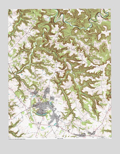
Hardinsburg, KY USGS Topographic Map
Click on map above to begin viewing in our Map Viewer.

This topographic map contains these locations and features:
Feature Name Type Latitude Longitude GNIS ID View Map
Bells SchoolSchoolN37.8148°W86.4516°486824View Map
BMH HeliportAirportN37.7667°W86.4408°517389View Map
Boiling SpringsSpringN37.8692°W86.3778°487631View Map
Breck Central Emergency Medical ServicesBuildingN37.7698°W86.4424°2719112View Map
Breckinridge CountyCivilN37.7733°W86.4293°516860View Map
Breckinridge County AirportAirportN37.7848°W86.4416°517390View Map
Breckinridge County Sheriff's OfficeBuildingN37.7809°W86.4615°2767607View Map
Breckinridge Memorial HospitalHospitalN37.7666°W86.4404°2660340View Map
Burned Courthouses Historical MarkerParkN37.7812°W86.4614°2744069View Map
City of HardinsburgCivilN37.7755°W86.4537°2403799View Map
Clifton ChurchChurchN37.8631°W86.3811°489673View Map
Clifton MillsPopulated PlaceN37.8673°W86.3880°507717View Map
CodyvillePopulated PlaceN37.7778°W86.4475°489765View Map
Dorridge CreekStreamN37.8373°W86.4616°491017View Map
Ephesus Cumberland Presbyterian ChurchChurchN37.7667°W86.4119°491796View Map
Freedom Cumberland Presbyterian ChurchChurchN37.8054°W86.3789°492505View Map
Freedom SchoolSchoolN37.8012°W86.3872°492510View Map
Friendship ChurchChurchN37.8126°W86.4411°492555View Map
Hardins CreekStreamN37.8676°W86.4403°493728View Map
HardinsburgPopulated PlaceN37.7801°W86.4605°493730View Map
Hardinsburg DivisionCivilN37.7761°W86.4392°1937043View Map
Hardinsburg Fire DepartmentBuildingN37.7828°W86.4612°2636592View Map
Hardinsburg Police DepartmentBuildingN37.7806°W86.4612°2767558View Map
Hardinsburg Reservoir (historical)ReservoirN37.7896°W86.4688°2742793View Map
HarnedPopulated PlaceN37.7517°W86.4136°493771View Map
Harned Volunteer Fire DepartmentBuildingN37.7526°W86.4164°2636867View Map
Horsley Chapel United Methodist ChurchChurchN37.8337°W86.4191°494617View Map
John Breckinridge Historical MarkerParkN37.7811°W86.4614°2744062View Map
Joseph Holt Historical MarkerParkN37.7809°W86.4613°2744131View Map
Meadows CreekStreamN37.8148°W86.4222°497998View Map
Miller HollowValleyN37.8634°W86.3994°498346View Map
Norton ValleyValleyN37.8564°W86.4210°499615View Map
Norton Valley SchoolSchoolN37.8376°W86.4011°499616View Map
Saint Romuald SchoolSchoolN37.7876°W86.4628°502735View Map
WHIC-AM (Hardinsburg)TowerN37.7626°W86.4394°517599View Map
WHIC-FM (Hardinsburg)TowerN37.7612°W86.4394°517699View Map
William Indian Bill Hardin Historical MarkerParkN37.7790°W86.4711°2744193View Map

Note: Coordinates in the location and feature list above are referenced to NAD83 datum.


Copyright (C) 2008-2025 Ryan Niemi / Sunset Dynamics ... All Rights Reserved