TopoQuest Logo
Do you find TopoQuest useful?
Help keep TopoQuest running and adding new maps/features by donating!
Bitcoin:  19c7KJd3qBynnjoSw5npx9KScwjBe4ifkT
Litecoin:  LXs6TkuXGGXo1vDsWCkWVdjQX94eUKd6ui
Home View Maps Find Maps Find Places Resources & Links


Hawthorne West, Nevada Topographic Map

USGS Map Title: Hawthorne West, NV
USGS Map MRC: 38118E6
DRG (GeoTIFF) Download: o38118e6.tif


Neighboring USGS Topographic Map Quads:


  Copper Canyon, NV  
38118F7
 

  Walker Lake, NV  
38118F6
 

  Ryan Canyon, NV  
38118F5
 

  Mount Grant, NV  
38118E7
 

  Hawthorne West, NV  
38118E6
 

  Hawthorne East, NV  
38118E5
 

  Corey Peak, NV  
38118D7
 

  Lucky Boy, NV  
38118D6
 

  Powell Mountain NE, NV  
38118D5


Map MRC Location:

N39°
W119°
N39°
W118°
H8 H7 H6 H5 H4 H3 H2 H1
G8 G7 G6 G5 G4 G3 G2 G1
F8 F7 F6 F5 F4 F3 F2 F1
E8 E7 E6 E5 E4 E3 E2 E1
D8 D7 D6 D5 D4 D3 D2 D1
C8 C7 C6 C5 C4 C3 C2 C1
B8 B7 B6 B5 B4 B3 B2 B1
A8 A7 A6 A5 A4 A3 A2 A1
N38°
W119°
N38°
W118°

Hawthorne West, NV USGS 1:24K Topographic Map Preview:
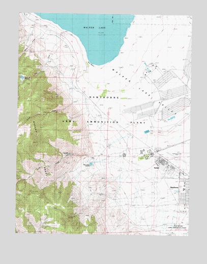
Hawthorne West, NV USGS Topographic Map
Click on map above to begin viewing in our Map Viewer.

This topographic map contains these locations and features:
Feature Name Type Latitude Longitude GNIS ID View Map
BabbittPopulated PlaceN38.5394°W118.6376°863907View Map
Babbitt Branch Post OfficePost OfficeN38.5399°W118.6415°865001View Map
Black Beauty DamDamN38.5416°W118.6960°863576View Map
Black Beauty ReservoirReservoirN38.5398°W118.6971°858294View Map
Cat CreekStreamN38.5460°W118.7129°839346View Map
Cat Creek DamDamN38.5449°W118.7110°863574View Map
Cat Creek ReservoirReservoirN38.5449°W118.7110°858295View Map
Chaney GulchValleyN38.6208°W118.7468°848110View Map
Day and Zimmerman Hawthorne Corporation Fire and Emergency ServicesBuildingN38.5447°W118.6558°2581347View Map
Hawthorne Census Designated PlaceCensusN38.5249°W118.6271°2408359View Map
Hawthorne DivisionCivilN38.5038°W118.7035°1937444View Map
Hawthorne Elementary SchoolSchoolN38.5285°W118.6296°855075View Map
Hawthorne Industrial AirportAirportN38.5378°W118.6290°864064View Map
Hawthorne Primary SchoolSchoolN38.5306°W118.6307°2079002View Map
Hawthorne TownshipCivilN38.5263°W118.6318°857634View Map
House CreekStreamN38.5766°W118.7001°841174View Map
House Creek CanyonValleyN38.5738°W118.7112°848109View Map
Lady Bird ParkParkN38.5330°W118.6254°864547View Map
Lefa Seran Skilled Nursing FacilityHospitalN38.5175°W118.6272°2076206View Map
Mineral County Fire DepartmentBuildingN38.5168°W118.6252°2581343View Map
Mineral County High SchoolSchoolN38.5266°W118.6299°858097View Map
Mineral County Sheriff's OfficeBuildingN38.5175°W118.6294°848142View Map
Mount Grant General HospitalHospitalN38.5170°W118.6276°848131View Map
Naval Ammunition Depot Branch Post Office (historical)Post OfficeN38.5458°W118.6546°865016View Map
Navy BeachBeachN38.5969°W118.6985°850706View Map
Nevada Highway Patrol Northern Command HawthorneBuildingN38.5350°W118.6303°2740081View Map
Rose CreekStreamN38.6110°W118.7204°843355View Map
Rose Creek DamDamN38.5866°W118.7476°863575View Map
Rose Creek ReservoirReservoirN38.5882°W118.7482°858293View Map
Schweer Housing AreaPopulated PlaceN38.5452°W118.6735°848143View Map
Sky View AcademySchoolN38.5360°W118.6435°2089673View Map
Squaw CreekStreamN38.6163°W118.7332°843957View Map
Walker Lake ValleyValleyN38.5963°W118.6646°844616View Map

Note: Coordinates in the location and feature list above are referenced to NAD83 datum.


Copyright (C) 2008-2025 Ryan Niemi / Sunset Dynamics ... All Rights Reserved