TopoQuest Logo
Do you find TopoQuest useful?
Help keep TopoQuest running and adding new maps/features by donating!
Bitcoin:  19c7KJd3qBynnjoSw5npx9KScwjBe4ifkT
Litecoin:  LXs6TkuXGGXo1vDsWCkWVdjQX94eUKd6ui
Home View Maps Find Maps Find Places Resources & Links


Iowa City East, Iowa Topographic Map

USGS Map Title: Iowa City East, IA
USGS Map MRC: 41091F4
DRG (GeoTIFF) Download: o41091f4.tif


Neighboring USGS Topographic Map Quads:


  Ely, IA  
41091G5
 

  Solon, IA  
41091G4
 

  Cedar Bluff, IA  
41091G3
 

  Iowa City West, IA  
41091F5
 

  Iowa City East, IA  
41091F4
 

  West Branch, IA  
41091F3
 

  Hills, IA  
41091E5
 

  West Liberty SW, IA  
41091E4
 

  West Liberty, IA  
41091E3


Map MRC Location:

N42°
W92°
N42°
W91°
H8 H7 H6 H5 H4 H3 H2 H1
G8 G7 G6 G5 G4 G3 G2 G1
F8 F7 F6 F5 F4 F3 F2 F1
E8 E7 E6 E5 E4 E3 E2 E1
D8 D7 D6 D5 D4 D3 D2 D1
C8 C7 C6 C5 C4 C3 C2 C1
B8 B7 B6 B5 B4 B3 B2 B1
A8 A7 A6 A5 A4 A3 A2 A1
N41°
W92°
N41°
W91°

Iowa City East, IA USGS 1:24K Topographic Map Preview:
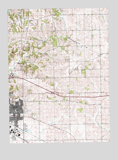
Iowa City East, IA USGS Topographic Map
Click on map above to begin viewing in our Map Viewer.

This topographic map contains these locations and features:
Feature Name Type Latitude Longitude GNIS ID View Map
Bethany Baptist ChurchChurchN41.6492°W91.4932°2002349View Map
Bon-Aire Mobile Home LodgePopulated PlaceN41.6292°W91.4946°2002381View Map
Brick Chapel (historical)ChurchN41.6634°W91.4479°465939View Map
Brick Chapel CemeteryCemeteryN41.6635°W91.4478°2002567View Map
Carthage Post Office (historical)Post OfficeN41.6292°W91.4668°2002274View Map
Carthage School (historical)SchoolN41.6706°W91.4249°465940View Map
Center SchoolSchoolN41.6420°W91.4252°465942View Map
Court Hill ParkParkN41.6559°W91.4913°465928View Map
Dodd Post Office (historical)Post OfficeN41.7431°W91.4752°2002271View Map
ElmiraPopulated PlaceN41.7228°W91.4249°464535View Map
Elmira (historical)LocaleN41.7228°W91.4249°2002282View Map
Fairview CemeteryCemeteryN41.6931°W91.4174°456485View Map
Fairview Golf CourseLocaleN41.6514°W91.4752°2002382View Map
First Presbyterian ChurchChurchN41.6664°W91.4952°2002363View Map
Graham (historical)Populated PlaceN41.6753°W91.4560°465949View Map
Helen Lemme Elementary SchoolSchoolN41.6620°W91.4879°465927View Map
Hi Point Golf CourseLocaleN41.6736°W91.4613°2002380View Map
Hope United Methodist ChurchChurchN41.6567°W91.4924°2002331View Map
Interchange 246CrossingN41.6867°W91.4982°2002585View Map
Interchange 249CrossingN41.6717°W91.4452°2002584View Map
Iowa City Church of ChristChurchN41.6492°W91.4779°2002312View Map
Ives (historical)LocaleN41.7278°W91.4266°2002254View Map
Ives Post Office (historical)Post OfficeN41.7278°W91.4266°2002253View Map
Lucas Elementary SchoolSchoolN41.6509°W91.4918°2002383View Map
Memory Gardens CemeteryCemeteryN41.6509°W91.4985°458982View Map
Mercer ParkParkN41.6450°W91.4954°465929View Map
Modern Manor Mobile Home ParkPopulated PlaceN41.6417°W91.4810°2002372View Map
MorsePopulated PlaceN41.7495°W91.4346°459249View Map
Morse (historical)LocaleN41.7495°W91.4346°2002269View Map
Morse CemeteryCemeteryN41.7441°W91.4437°459250View Map
Morse Community BuildingBuildingN41.7486°W91.4324°465924View Map
Morse Post Office (historical)Post OfficeN41.7495°W91.4346°2002270View Map
New Newport CemeteryCemeteryN41.7364°W91.4966°2002568View Map
NewportPopulated PlaceN41.7386°W91.4741°459513View Map
Newport Centre Post Office (historical)Post OfficeN41.7431°W91.4821°2002272View Map
Newport Post Office (historical)Post OfficeN41.7386°W91.4741°2002273View Map
OasisPopulated PlaceN41.7061°W91.3854°464679View Map
Oasis (historical)LocaleN41.7061°W91.3854°2002276View Map
Oasis CemeteryCemeteryN41.7005°W91.3861°459792View Map
Oasis Post Office (historical)Post OfficeN41.7061°W91.3854°2002275View Map
Pheasant Hill ParkParkN41.6620°W91.4954°465926View Map
Prairie Dale SchoolSchoolN41.6439°W91.4635°465946View Map
Railroad SchoolSchoolN41.6706°W91.4618°465947View Map
Robert Lucas Elementary SchoolSchoolN41.6508°W91.4921°460693View Map
Saint Marks United Methodist ChurchChurchN41.6600°W91.4957°2002332View Map
Saint Marys CemeteryCemeteryN41.7372°W91.4929°2002569View Map
Saint Marys ChurchChurchN41.7370°W91.4932°461201View Map
Scott ParkParkN41.6550°W91.4785°465930View Map
Southeast Junior High SchoolSchoolN41.6453°W91.4997°461827View Map
Southeastern Iowa Synod Evangelical Lutheran ChurchChurchN41.6903°W91.4946°2002359View Map
Sunrise Mobile Home VillagePopulated PlaceN41.6389°W91.4810°2002373View Map
The Church of Jesus Christ of Latter Day SaintsChurchN41.6467°W91.4966°2002335View Map
Township of GrahamCivilN41.7293°W91.4148°467920View Map
Township of ScottCivilN41.6416°W91.4221°468672View Map
Victory Temple ChurchChurchN41.6492°W91.4935°2002347View Map
Willowwind SchoolSchoolN41.6511°W91.4941°2720000View Map

Note: Coordinates in the location and feature list above are referenced to NAD83 datum.


Copyright (C) 2008-2024 Ryan Niemi / Sunset Dynamics ... All Rights Reserved