TopoQuest Logo
Do you find TopoQuest useful?
Help keep TopoQuest running and adding new maps/features by donating!
Bitcoin:  19c7KJd3qBynnjoSw5npx9KScwjBe4ifkT
Litecoin:  LXs6TkuXGGXo1vDsWCkWVdjQX94eUKd6ui
Home View Maps Find Maps Find Places Resources & Links


Lewis Run, Pennsylvania Topographic Map

USGS Map Title: Lewis Run, PA
USGS Map MRC: 41078G6
DRG (GeoTIFF) Download: o41078g6.tif


Neighboring USGS Topographic Map Quads:


  Stickney, PA  
41078H7
 

  Bradford, PA  
41078H6
 

  Derrick City, PA  
41078H5
 

  Westline, PA  
41078G7
 

  Lewis Run, PA  
41078G6
 

  Cyclone, PA  
41078G5
 

  Kane, PA  
41078F7
 

  Mount Jewett, PA  
41078F6
 

  Hazel Hurst, PA  
41078F5


Map MRC Location:

N42°
W79°
N42°
W78°
H8 H7 H6 H5 H4 H3 H2 H1
G8 G7 G6 G5 G4 G3 G2 G1
F8 F7 F6 F5 F4 F3 F2 F1
E8 E7 E6 E5 E4 E3 E2 E1
D8 D7 D6 D5 D4 D3 D2 D1
C8 C7 C6 C5 C4 C3 C2 C1
B8 B7 B6 B5 B4 B3 B2 B1
A8 A7 A6 A5 A4 A3 A2 A1
N41°
W79°
N41°
W78°

Lewis Run, PA USGS 1:24K Topographic Map Preview:
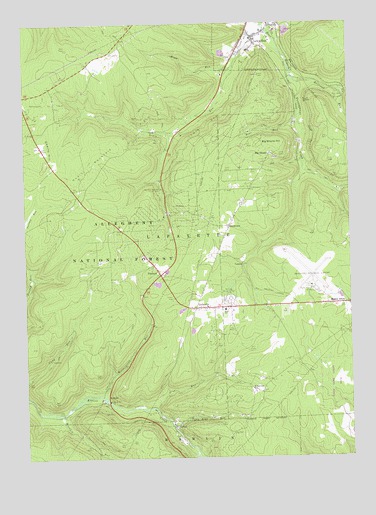
Lewis Run, PA USGS Topographic Map
Click on map above to begin viewing in our Map Viewer.

This topographic map contains these locations and features:
Feature Name Type Latitude Longitude GNIS ID View Map
Arch BridgeBridgeN41.8286°W78.6475°2680863View Map
Bear RunStreamN41.8462°W78.6434°1209403View Map
Big ShantyPopulated PlaceN41.8376°W78.6547°1209422View Map
Big Shanty HillSummitN41.8403°W78.6597°1209423View Map
Big Shanty StationLocaleN41.8467°W78.6456°1210283View Map
Borough of Lewis RunCivilN41.8694°W78.6599°1215432View Map
Bradford Regional AirportAirportN41.7995°W78.6395°1210253View Map
Cherry HillSummitN41.8345°W78.7414°1209497View Map
Crawford JunctionLocaleN41.7962°W78.6472°1211471View Map
Droney RunStreamN41.8545°W78.6270°1209568View Map
Elk Bar RunStreamN41.7651°W78.7075°1210268View Map
Federal Correctional Institution McKeanBuildingN41.7982°W78.6862°2757210View Map
GuffeyPopulated PlaceN41.7592°W78.6934°1209649View Map
IrishtownPopulated PlaceN41.8165°W78.6711°1209691View Map
Kennedy Springs Picnic AreaLocaleN41.8276°W78.6975°1209724View Map
LafayettePopulated PlaceN41.7937°W78.6797°1209740View Map
Lafayette Township Volunteer Fire and Rescue Station 21BuildingN41.7952°W78.6922°2645787View Map
Lewis HollowValleyN41.8647°W78.6697°1210378View Map
Lewis RunStreamN41.8740°W78.6570°1209752View Map
Lewis RunPopulated PlaceN41.8709°W78.6614°1210186View Map
Lewis RunStreamN41.8740°W78.6572°1212819View Map
Lewis Run Oil FieldOilfieldN41.8492°W78.6717°1209753View Map
Lewis Run Post OfficePost OfficeN41.8726°W78.6568°2772793View Map
Lewis Run Volunteer Fire DepartmentBuildingN41.8725°W78.6572°2645137View Map
Marshburg Oil FieldOilfieldN41.8517°W78.7423°1209798View Map
McKean Memorial Park CemeteryCemeteryN41.7949°W78.6706°1209807View Map
Miam HollowValleyN41.8614°W78.6717°1210389View Map
Miam RunStreamN41.8626°W78.6686°1209817View Map
Mount AltonPopulated PlaceN41.7942°W78.6278°1209834View Map
Music Mountain Oil FieldOilfieldN41.8403°W78.7159°1209846View Map
OlivedaleLocaleN41.7623°W78.7359°1210280View Map
Orange CreekStreamN41.8286°W78.6453°2710667View Map
Pine Acres Golf CourseLocaleN41.8662°W78.7148°1210356View Map
Pine RunStreamN41.7640°W78.7000°1209894View Map
Railroad RunStreamN41.8578°W78.6442°1209914View Map
Riderville StationLocaleN41.7862°W78.6275°1210284View Map
RitervillePopulated PlaceN41.7695°W78.6620°1209929View Map
Ryan SchoolSchoolN41.7928°W78.6731°1209946View Map
School Number 3SchoolN41.8176°W78.6697°1210281View Map
State Game Lands Number Sixty TwoParkN41.7709°W78.6270°1210468View Map
TaintorPopulated PlaceN41.8062°W78.6661°1210028View Map
TallyhoPopulated PlaceN41.7670°W78.7184°1210029View Map
TaylorLocaleN41.8301°W78.6281°1210282View Map
TimbuckPopulated PlaceN41.8031°W78.6978°1210043View Map
Town Line RunStreamN41.7595°W78.6936°1210054View Map
Township of LafayetteCivilN41.8175°W78.6917°1216788View Map
Windfall RunStreamN41.7628°W78.7364°1210127View Map
Wintergreen RunStreamN41.7681°W78.7206°1210233View Map

Note: Coordinates in the location and feature list above are referenced to NAD83 datum.


Copyright (C) 2008-2024 Ryan Niemi / Sunset Dynamics ... All Rights Reserved