TopoQuest Logo
Do you find TopoQuest useful?
Help keep TopoQuest running and adding new maps/features by donating!
Bitcoin:  19c7KJd3qBynnjoSw5npx9KScwjBe4ifkT
Litecoin:  LXs6TkuXGGXo1vDsWCkWVdjQX94eUKd6ui
Home View Maps Find Maps Find Places Resources & Links


Marseilles, Illinois Topographic Map

USGS Map Title: Marseilles, IL
USGS Map MRC: 41088C6
DRG (GeoTIFF) Download: o41088c6.tif


Neighboring USGS Topographic Map Quads:


  Wedron, IL  
41088D7
 

  Serena, IL  
41088D6
 

  Stavanger, IL  
41088D5
 

  Ottawa, IL  
41088C7
 

  Marseilles, IL  
41088C6
 

  Seneca, IL  
41088C5
 

  Streator North, IL  
41088B7
 

  Ransom, IL  
41088B6
 

  Kinsman, IL  
41088B5


Map MRC Location:

N42°
W89°
N42°
W88°
H8 H7 H6 H5 H4 H3 H2 H1
G8 G7 G6 G5 G4 G3 G2 G1
F8 F7 F6 F5 F4 F3 F2 F1
E8 E7 E6 E5 E4 E3 E2 E1
D8 D7 D6 D5 D4 D3 D2 D1
C8 C7 C6 C5 C4 C3 C2 C1
B8 B7 B6 B5 B4 B3 B2 B1
A8 A7 A6 A5 A4 A3 A2 A1
N41°
W89°
N41°
W88°

Marseilles, IL USGS 1:24K Topographic Map Preview:
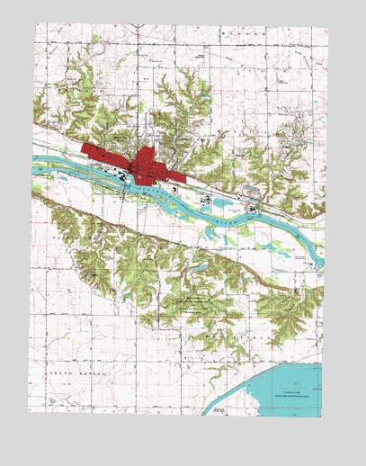
Marseilles, IL USGS Topographic Map
Click on map above to begin viewing in our Map Viewer.

This topographic map contains these locations and features:
Feature Name Type Latitude Longitude GNIS ID View Map
Ancient Oaks Day Use AreaParkN41.3264°W88.7406°1816015View Map
Bells IslandIslandN41.3289°W88.7362°404145View Map
Brookfield ChurchChurchN41.2517°W88.6851°404908View Map
Brookfield SpringSpringN41.3031°W88.6701°404909View Map
Butterfield School (historical)SchoolN41.3164°W88.6431°1748212View Map
Christian CemeteryCemeteryN41.3611°W88.6517°406090View Map
Church of the NazareneChurchN41.3278°W88.6865°1816025View Map
City of MarseillesCivilN41.2915°W88.6911°2395020View Map
Clarks IslandIslandN41.3186°W88.6917°424540View Map
David Gillespie AirportAirportN41.3636°W88.6784°427520View Map
First Baptist ChurchChurchN41.3289°W88.7004°1816042View Map
First Church of GodChurchN41.3281°W88.6951°1816046View Map
First Congregational ChurchChurchN41.3298°W88.7051°1816048View Map
Gage School (historical)SchoolN41.2675°W88.6742°1748222View Map
Galloway CemeteryCemeteryN41.3108°W88.7183°408856View Map
Galloway School (historical)SchoolN41.3159°W88.7112°1748223View Map
Great Falls of the Illinois RiverFallsN41.3278°W88.7251°1816061View Map
Gum CreekStreamN41.3225°W88.6954°409563View Map
Hickory Point School (historical)SchoolN41.2964°W88.7306°1748230View Map
Illini State ParkParkN41.3217°W88.7159°410757View Map
Immanuel Lutheran ChurchChurchN41.3298°W88.7056°1816067View Map
Johnson IslandIslandN41.3125°W88.6590°411168View Map
LaSalle County Nuclear Station Cooling DamDamN41.2508°W88.6750°1692414View Map
LaSalle County Nuclear Station Cooling PondReservoirN41.2547°W88.6370°1692415View Map
LaSalle Lake State Fish and Wildlife AreaParkN41.2542°W88.6306°1816076View Map
Lincoln School (historical)SchoolN41.3273°W88.6920°1816081View Map
Long CreekStreamN41.3286°W88.7220°412560View Map
Loring School (historical)SchoolN41.3684°W88.7051°1748244View Map
Mallard BayBayN41.3203°W88.7004°1816084View Map
Manlius Methodist CemeteryCemeteryN41.3694°W88.6367°412892View Map
Marsatawa Country Club (historical)LocaleN41.3189°W88.7048°1816085View Map
MarseillesPopulated PlaceN41.3309°W88.7081°413037View Map
Marseilles Area Ambulance ServiceBuildingN41.3277°W88.7070°2681848View Map
Marseilles CanalCanalN41.3256°W88.7265°413038View Map
Marseilles City Police DepartmentBuildingN41.3278°W88.7068°2756938View Map
Marseilles DamDamN41.3231°W88.7081°413039View Map
Marseilles Elementary SchoolSchoolN41.3242°W88.6976°1816086View Map
Marseilles Fire Protection DistrictBuildingN41.3280°W88.7078°2681736View Map
Marseilles PoolReservoirN41.3231°W88.7081°1690865View Map
Marseilles Post OfficePost OfficeN41.3293°W88.7077°1816087View Map
Marseilles State Fish and Wildlife AreaParkN41.2884°W88.6801°1748246View Map
Maxton and Woodside CemeteryCemeteryN41.2753°W88.6270°413146View Map
McIntyre School (historical)SchoolN41.3036°W88.6823°1748247View Map
McKinley School (historical)SchoolN41.3289°W88.7012°1816090View Map
Mitchell RLA AirportAirportN41.3606°W88.6452°427518View Map
Nichols CemeteryCemeteryN41.3652°W88.7066°414508View Map
North Kickapoo CreekStreamN41.3475°W88.6251°414620View Map
Old Brumbach CemeteryCemeteryN41.3636°W88.7009°414993View Map
Parkview Baptist ChurchChurchN41.3195°W88.7117°415411View Map
Peddicord School (historical)SchoolN41.3720°W88.6712°1748254View Map
Person CreekStreamN41.3242°W88.7231°415573View Map
Prospect School (historical)SchoolN41.2670°W88.7226°1748255View Map
Rat RunStreamN41.3036°W88.6295°416399View Map
Riverview CemeteryCemeteryN41.3313°W88.6868°416730View Map
Saint Josephs Catholic ChurchChurchN41.3275°W88.7081°1816128View Map
School Number 7 (historical)SchoolN41.3553°W88.6506°1748263View Map
Shaver CemeteryCemeteryN41.3570°W88.7362°418302View Map
South Kickapoo CreekStreamN41.3111°W88.6726°418793View Map
Spring BrookStreamN41.2986°W88.6259°418927View Map
Spring Brook AirportAirportN41.2977°W88.6326°427797View Map
Spring Brook MarinaLocaleN41.2989°W88.6290°418928View Map
Stebbins CemeteryCemeteryN41.3478°W88.6460°419085View Map
Township of BrookfieldCivilN41.2522°W88.6482°428713View Map
Township of ManliusCivilN41.3386°W88.6444°429319View Map
Trinity Lutheran ChurchChurchN41.3281°W88.6992°1816151View Map
Vincent School (historical)SchoolN41.3689°W88.7451°1748271View Map
Walbridge CreekStreamN41.3314°W88.7356°420386View Map
Washington School (historical)SchoolN41.3325°W88.7142°1816158View Map
Wildcat BogSwampN41.3256°W88.7423°1816161View Map

Note: Coordinates in the location and feature list above are referenced to NAD83 datum.


Copyright (C) 2008-2024 Ryan Niemi / Sunset Dynamics ... All Rights Reserved