TopoQuest Logo
Do you find TopoQuest useful?
Help keep TopoQuest running and adding new maps/features by donating!
Bitcoin:  19c7KJd3qBynnjoSw5npx9KScwjBe4ifkT
Litecoin:  LXs6TkuXGGXo1vDsWCkWVdjQX94eUKd6ui
Home View Maps Find Maps Find Places Resources & Links


Meehan, Wisconsin Topographic Map

USGS Map Title: Meehan, WI
USGS Map MRC: 44089D6
DRG (GeoTIFF) Download: o44089d6.tif


Neighboring USGS Topographic Map Quads:


  Junction City, WI  
44089E7
 

  Rocky Run, WI  
44089E6
 

  Stevens Point, WI  
44089E5
 

  Wisconsin Rapids North, WI  
44089D7
 

  Meehan, WI  
44089D6
 

  Whiting, WI  
44089D5
 

  Wisconsin Rapids South, WI  
44089C7
 

  Kellner, WI  
44089C6
 

  Bancroft, WI  
44089C5


Map MRC Location:

N45°
W90°
N45°
W89°
H8 H7 H6 H5 H4 H3 H2 H1
G8 G7 G6 G5 G4 G3 G2 G1
F8 F7 F6 F5 F4 F3 F2 F1
E8 E7 E6 E5 E4 E3 E2 E1
D8 D7 D6 D5 D4 D3 D2 D1
C8 C7 C6 C5 C4 C3 C2 C1
B8 B7 B6 B5 B4 B3 B2 B1
A8 A7 A6 A5 A4 A3 A2 A1
N44°
W90°
N44°
W89°

Meehan, WI USGS 1:24K Topographic Map Preview:
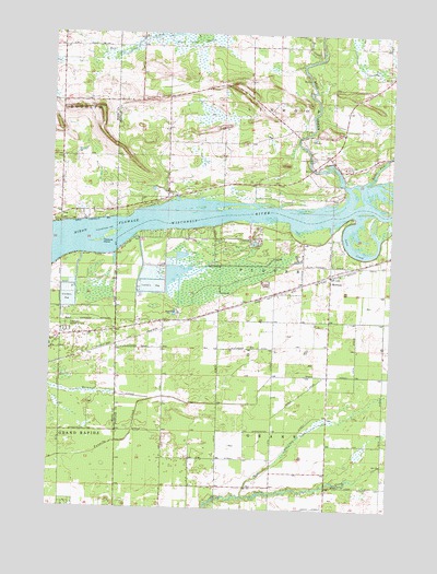
Meehan, WI USGS Topographic Map
Click on map above to begin viewing in our Map Viewer.

This topographic map contains these locations and features:
Feature Name Type Latitude Longitude GNIS ID View Map
Bear CreekStreamN44.4933°W89.6535°1561357View Map
Biron FlowageReservoirN44.4487°W89.7063°1561825View Map
Hill View School (historical)SchoolN44.4672°W89.7465°1847030View Map
La Follette School (historical)SchoolN44.4850°W89.6979°1851498View Map
Linwood Union CemeteryCemeteryN44.4675°W89.6534°1568157View Map
Love CreekGutN44.4439°W89.6393°1568703View Map
MeehanPopulated PlaceN44.4361°W89.6473°1569314View Map
Mill CreekStreamN44.4600°W89.6412°1569477View Map
Pearl School (historical)SchoolN44.4219°W89.7262°1847073View Map
Pleasure IslandIslandN44.4461°W89.7301°1571679View Map
Restlawn Memorial ParkParkN44.4222°W89.7443°1572218View Map
Rocky RunStreamN44.4608°W89.6343°1572516View Map
Rudolph Volunteer Fire Department Station 2 Town of LinwoodBuildingN44.4661°W89.6456°2697863View Map
Town of LinwoodCivilN44.4879°W89.6590°1583577View Map
WIZD-FM (Rudolph)TowerN44.4819°W89.6762°1582627View Map
Woodville School (historical)SchoolN44.4677°W89.6546°1851598View Map

Note: Coordinates in the location and feature list above are referenced to NAD83 datum.


Copyright (C) 2008-2025 Ryan Niemi / Sunset Dynamics ... All Rights Reserved