TopoQuest Logo
Do you find TopoQuest useful?
Help keep TopoQuest running and adding new maps/features by donating!
Bitcoin:  19c7KJd3qBynnjoSw5npx9KScwjBe4ifkT
Litecoin:  LXs6TkuXGGXo1vDsWCkWVdjQX94eUKd6ui
Home View Maps Find Maps Find Places Resources & Links


Abingdon, Illinois Topographic Map

USGS Map Title: Abingdon, IL
USGS Map MRC: 40090G4
DRG (GeoTIFF) Download: o40090g4.tif


Neighboring USGS Topographic Map Quads:


  Cameron, IL  
40090H5
 

  Galesburg West, IL  
40090H4
 

  Galesburg East, IL  
40090H3
 

  Berwick, IL  
40090G5
 

  Abingdon, IL  
40090G4
 

  DeLong, IL  
40090G3
 

  Greenbush, IL  
40090F5
 

  Avon, IL  
40090F4
 

  London Mills, IL  
40090F3


Map MRC Location:

N41°
W91°
N41°
W90°
H8 H7 H6 H5 H4 H3 H2 H1
G8 G7 G6 G5 G4 G3 G2 G1
F8 F7 F6 F5 F4 F3 F2 F1
E8 E7 E6 E5 E4 E3 E2 E1
D8 D7 D6 D5 D4 D3 D2 D1
C8 C7 C6 C5 C4 C3 C2 C1
B8 B7 B6 B5 B4 B3 B2 B1
A8 A7 A6 A5 A4 A3 A2 A1
N40°
W91°
N40°
W90°

Abingdon, IL USGS 1:24K Topographic Map Preview:
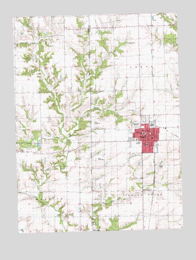
Abingdon, IL USGS Topographic Map
Click on map above to begin viewing in our Map Viewer.

This topographic map contains these locations and features:
Feature Name Type Latitude Longitude GNIS ID View Map
AbingdonPopulated PlaceN40.8045°W90.4018°403320View Map
Abingdon CemeteryCemeteryN40.8111°W90.4088°1815920View Map
Abingdon City HallBuildingN40.8025°W90.3979°1815921View Map
Abingdon Fire Protection District Station 1BuildingN40.8021°W90.3979°2640235View Map
Abingdon High SchoolSchoolN40.8003°W90.4071°1719579View Map
Abingdon Junior High SchoolSchoolN40.7992°W90.4010°1815922View Map
Abingdon Police DepartmentBuildingN40.8022°W90.3978°2756935View Map
Abingdon Post OfficePost OfficeN40.8025°W90.3998°1815923View Map
Abingdon Water WorksLocaleN40.8048°W90.3960°1815924View Map
All Souls Roman Catholic ChurchChurchN40.8014°W90.4021°1815925View Map
Boydston-Dawdy CemeteryCemeteryN40.7729°W90.4027°1719588View Map
Cherry Farm School (historical)SchoolN40.8456°W90.4557°406014View Map
Cherry Grove CemeteryCemeteryN40.8188°W90.4092°1719606View Map
Cherry Grove School (historical)SchoolN40.8248°W90.4057°406018View Map
City of AbingdonCivilN40.8038°W90.4009°2393876View Map
Cross Lane School (historical)SchoolN40.8025°W90.4340°406829View Map
First Christian ChurchChurchN40.7989°W90.3990°1815955View Map
First Church of the NazareneChurchN40.8064°W90.3982°1815958View Map
First Congregational ChurchChurchN40.8039°W90.3999°1815960View Map
First Methodist ChurchChurchN40.8056°W90.3996°1815962View Map
Hedding Grade SchoolSchoolN40.8056°W90.4029°1719651View Map
Heller School (historical)SchoolN40.8625°W90.3857°410037View Map
Indian Point School (historical)SchoolN40.7725°W90.3974°410876View Map
Italian SloughStreamN40.7748°W90.4057°406923View Map
John Mosser Public LibraryBuildingN40.8023°W90.3990°1815980View Map
Kenan School (historical)SchoolN40.8748°W90.4610°411393View Map
Latimer CreekStreamN40.8117°W90.4526°411842View Map
Legion ParkParkN40.8023°W90.4085°1719663View Map
Lincoln Public School (historical)SchoolN40.8064°W90.3990°1815986View Map
Louisville School (historical)SchoolN40.8525°W90.4046°412683View Map
Malone Landing Strip (historical)AirportN40.8125°W90.4404°1720339View Map
Meridians CemeteryCemeteryN40.7976°W90.4943°1719674View Map
Pretty Prairie School (historical)SchoolN40.7739°W90.4521°416207View Map
Sacred Hearth Catholic ChurchChurchN40.8067°W90.3990°1815997View Map
SaludaPopulated PlaceN40.8720°W90.3943°423150View Map
Slug RunStreamN40.8050°W90.4610°418610View Map
Stringtown School (historical)SchoolN40.8745°W90.4990°1719701View Map
Township of CedarCivilN40.8453°W90.3852°428779View Map
Township of FloydCivilN40.8455°W90.4990°429010View Map
Township of Indian PointCivilN40.7579°W90.3863°429167View Map
Warren School (historical)SchoolN40.8678°W90.4351°420538View Map
Washington Public School (historical)SchoolN40.7984°W90.4004°1816006View Map
Wolford's AirportAirportN40.7936°W90.4377°427002View Map

Note: Coordinates in the location and feature list above are referenced to NAD83 datum.


Copyright (C) 2008-2024 Ryan Niemi / Sunset Dynamics ... All Rights Reserved