TopoQuest Logo
Do you find TopoQuest useful?
Help keep TopoQuest running and adding new maps/features by donating!
Bitcoin:  19c7KJd3qBynnjoSw5npx9KScwjBe4ifkT
Litecoin:  LXs6TkuXGGXo1vDsWCkWVdjQX94eUKd6ui
Home View Maps Find Maps Find Places Resources & Links


Nashoba, Oklahoma Topographic Map

USGS Map Title: Nashoba, OK
USGS Map MRC: 34095D2
DRG (GeoTIFF) Download: o34095d2.tif


Neighboring USGS Topographic Map Quads:


  Clayton, OK  
34095E3
 

  Albion SW, OK  
34095E2
 

  Albion SE, OK  
34095E1
 

  Wildhorse Mountain, OK  
34095D3
 

  Nashoba, OK  
34095D2
 

  Clebit, OK  
34095D1
 

  Cloudy, OK  
34095C3
 

  Caney Mountain, OK  
34095C2
 

  Signal Mountain, OK  
34095C1


Map MRC Location:

N35°
W96°
N35°
W95°
H8 H7 H6 H5 H4 H3 H2 H1
G8 G7 G6 G5 G4 G3 G2 G1
F8 F7 F6 F5 F4 F3 F2 F1
E8 E7 E6 E5 E4 E3 E2 E1
D8 D7 D6 D5 D4 D3 D2 D1
C8 C7 C6 C5 C4 C3 C2 C1
B8 B7 B6 B5 B4 B3 B2 B1
A8 A7 A6 A5 A4 A3 A2 A1
N34°
W96°
N34°
W95°

Nashoba, OK USGS 1:24K Topographic Map Preview:
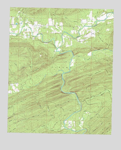
Nashoba, OK USGS Topographic Map
Click on map above to begin viewing in our Map Viewer.

This topographic map contains these locations and features:
Feature Name Type Latitude Longitude GNIS ID View Map
Black ForkStreamN34.4598°W95.1925°1090197View Map
Black Fork CemeteryCemeteryN34.4832°W95.2486°1090198View Map
Buzzard CreekStreamN34.3887°W95.1602°1090763View Map
Cripple CreekStreamN34.4818°W95.2316°1091826View Map
Davis BranchStreamN34.4818°W95.1619°1091948View Map
Garland CreekStreamN34.4748°W95.1866°1093126View Map
Harris CreekStreamN34.3798°W95.1788°1093571View Map
Jack CreekStreamN34.4357°W95.1844°1094147View Map
Leflore CreekStreamN34.4951°W95.1255°1094568View Map
Little River RanchLocaleN34.3823°W95.1736°1094809View Map
Middle Harris TrailTrailN34.4026°W95.1922°1095359View Map
Musket MountainSummitN34.4323°W95.1516°1095715View Map
NashobaPopulated PlaceN34.4820°W95.2152°1095751View Map
Nashoba Elementary SchoolSchoolN34.4822°W95.2090°1803493View Map
Nashoba Fire DepartmentBuildingN34.4824°W95.2107°2657194View Map
Nashoba Indian CemeteryCemeteryN34.4850°W95.2353°2708542View Map
NoliaPopulated PlaceN34.4765°W95.1516°1100677View Map
Nolia CemeteryCemeteryN34.4690°W95.1602°1095897View Map
North Harris CreekStreamN34.3795°W95.1997°1095966View Map
North Jack CreekStreamN34.4226°W95.2172°1095972View Map
Paley CreekStreamN34.4884°W95.1444°1096389View Map
Pickens CreekStreamN34.3804°W95.1586°1096614View Map
Pickens Creek TrailTrailN34.3979°W95.1780°1096616View Map
South Harris TrailTrailN34.3807°W95.2013°1098250View Map
Trails End CampLocaleN34.4579°W95.1872°1098967View Map
Watson CreekStreamN34.4520°W95.1727°1099431View Map

Note: Coordinates in the location and feature list above are referenced to NAD83 datum.


Copyright (C) 2008-2025 Ryan Niemi / Sunset Dynamics ... All Rights Reserved