TopoQuest Logo
Do you find TopoQuest useful?
Help keep TopoQuest running and adding new maps/features by donating!
Bitcoin:  19c7KJd3qBynnjoSw5npx9KScwjBe4ifkT
Litecoin:  LXs6TkuXGGXo1vDsWCkWVdjQX94eUKd6ui
Home View Maps Find Maps Find Places Resources & Links


North Hartland, Vermont Topographic Map

USGS Map Title: North Hartland, VT
USGS Map MRC: 43072E3
DRG (GeoTIFF) Download: o43072e3.tif


Neighboring USGS Topographic Map Quads:


  Quechee, VT  
43072F4
 

  Hanover, NH  
43072F3


  Hartland, VT  
43072E4
 

  North Hartland, VT  
43072E3
 

  North Grantham, NH  
43072E2
 

  Windsor, VT  
43072D4
 

  Claremont North, NH  
43072D3
 

  Grantham, NH  
43072D2


Map MRC Location:

N44°
W73°
N44°
W72°
H8 H7 H6 H5 H4 H3 H2 H1
G8 G7 G6 G5 G4 G3 G2 G1
F8 F7 F6 F5 F4 F3 F2 F1
E8 E7 E6 E5 E4 E3 E2 E1
D8 D7 D6 D5 D4 D3 D2 D1
C8 C7 C6 C5 C4 C3 C2 C1
B8 B7 B6 B5 B4 B3 B2 B1
A8 A7 A6 A5 A4 A3 A2 A1
N43°
W73°
N43°
W72°

North Hartland, VT USGS 1:24K Topographic Map Preview:
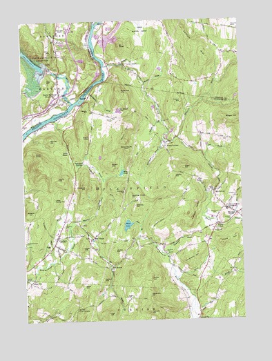
North Hartland, VT USGS Topographic Map
Click on map above to begin viewing in our Map Viewer.

This topographic map contains these locations and features:
Feature Name Type Latitude Longitude GNIS ID View Map
Air-Wood HeliportAirportN43.5431°W72.3518°873434View Map
Altai HillSummitN43.5032°W72.3275°865224View Map
Barnes LibraryBuildingN43.5462°W72.2590°1917399View Map
Barrett Four CornersLocaleN43.5056°W72.3448°865387View Map
Beauty HillSummitN43.5861°W72.3374°865469View Map
Beaver BrookStreamN43.5840°W72.3562°865476View Map
Black HillRidgeN43.5749°W72.3177°865624View Map
Bloods BrookStreamN43.6062°W72.3262°865667View Map
Blow-Me-Down BridgeBridgeN43.5176°W72.3740°1917403View Map
Bryant BrookStreamN43.5231°W72.3259°865836View Map
Bryant PondLakeN43.5392°W72.2625°865841View Map
Burnaps IslandIslandN43.5917°W72.3404°865867View Map
Burr BrookStreamN43.5348°W72.3081°865879View Map
Clay BrookStreamN43.5248°W72.3581°866197View Map
Clay HillSummitN43.6001°W72.3604°1456912View Map
Colby CemeteryCemeteryN43.5795°W72.3691°866255View Map
Colby HillSummitN43.5633°W72.2824°866257View Map
Cole BrookStreamN43.5670°W72.2704°866279View Map
Cooney HollowValleyN43.5442°W72.3336°866327View Map
Coreyville CemeteryCemeteryN43.5717°W72.2937°866341View Map
Cotton HillSummitN43.5907°W72.2842°866360View Map
Cranberry PondLakeN43.6220°W72.3227°866384View Map
Daniels BrookStreamN43.5831°W72.2945°866474View Map
Daniels CemeteryCemeteryN43.5837°W72.3226°866475View Map
Farnum HillRidgeN43.6084°W72.2683°866843View Map
Fernald HillSummitN43.5044°W72.3038°866861View Map
Fifield HillRidgeN43.5318°W72.2616°866867View Map
Frenchs LedgeBenchN43.5453°W72.2762°866984View Map
Frog HollowValleyN43.5407°W72.2570°866990View Map
Gallup CemeteryCemeteryN43.5819°W72.3746°1457510View Map
Gilkey CemeteriesCemeteryN43.5402°W72.3412°867068View Map
Governors HillSummitN43.5956°W72.3168°867158View Map
Hanchetts BrookStreamN43.5951°W72.3368°867354View Map
Hartland Volunteer Fire Department and Rescue Squad Station 2BuildingN43.5952°W72.3537°2121298View Map
Hell HollowPopulated PlaceN43.5231°W72.3248°871186View Map
Hibbard BrookStreamN43.5759°W72.2854°867473View Map
Hilliard BrookStreamN43.5759°W72.2937°867493View Map
Home HillSummitN43.5592°W72.3547°867574View Map
Hopkins CemeteryCemeteryN43.5251°W72.2515°867592View Map
Howe HillSummitN43.5304°W72.3412°867636View Map
Huggin CemeteryCemeteryN43.5099°W72.3166°867669View Map
Johnston IslandIslandN43.6248°W72.3295°867800View Map
Jordan HillSummitN43.5296°W72.3228°867811View Map
Jug HillSummitN43.5556°W72.3336°867818View Map
Kenyon HillSummitN43.5173°W72.3301°867849View Map
Kimball Union AcademySchoolN43.5455°W72.2574°867882View Map
Ladieu HillSummitN43.5602°W72.2881°867923View Map
Lewis SwaleSwampN43.5812°W72.3548°868000View Map
Little Home HillSummitN43.5507°W72.3569°868062View Map
Martin BrookStreamN43.5987°W72.3037°868285View Map
Meeting House HillSummitN43.5515°W72.3130°872277View Map
Meridan Post OfficePost OfficeN43.5461°W72.2569°1917445View Map
MeridenPopulated PlaceN43.5440°W72.2526°868389View Map
Meriden BridgeBridgeN43.5534°W72.2662°1917397View Map
Meriden Fire DepartmentBuildingN43.5415°W72.2568°2605172View Map
Mill CemeteryCemeteryN43.5536°W72.2676°868444View Map
Mill HollowPopulated PlaceN43.5534°W72.2654°871205View Map
Mill VillagePopulated PlaceN43.5342°W72.3359°871206View Map
Miller HillSummitN43.6120°W72.3579°1458476View Map
Moses PondLakeN43.5398°W72.3156°868575View Map
Moulton-Yard CemeteryCemeteryN43.5376°W72.2640°868579View Map
Mount FinishSummitN43.6146°W72.3179°866869View Map
Mud PondLakeN43.5617°W72.3183°868642View Map
Newton BrookStreamN43.5403°W72.2568°868734View Map
North HartlandPopulated PlaceN43.5928°W72.3518°1458736View Map
North Hartland Census Designated PlaceCensusN43.5937°W72.3578°2586644View Map
North Hartland Community ChurchChurchN43.5895°W72.3590°1922483View Map
North Hartland DamDamN43.6045°W72.3606°1458737View Map
North Hartland Dam Recreation AreaParkN43.6051°W72.3593°1922484View Map
North Hartland Post OfficePost OfficeN43.5910°W72.3563°1922485View Map
Ottauquechee RiverStreamN43.5906°W72.3462°1461248View Map
Ottauquechee River BridgeBridgeN43.6026°W72.3543°1922515View Map
Penniman BrookStreamN43.5270°W72.2934°869064View Map
Penniman CemeteryCemeteryN43.5285°W72.2944°869065View Map
Penniman HillRidgeN43.5253°W72.2828°869066View Map
Pinnacle HillSummitN43.5543°W72.3170°869210View Map
PlainfieldPopulated PlaceN43.5342°W72.3562°869244View Map
Plainfield CemeteryCemeteryN43.5396°W72.3519°869245View Map
Plainfield Census Designated PlaceCensusN43.5345°W72.3536°2629737View Map
Plainfield Community Baptist ChurchChurchN43.5348°W72.3565°1917401View Map
Plainfield Elementary SchoolSchoolN43.5421°W72.2673°1917400View Map
Plainfield Fire DepartmentBuildingN43.5266°W72.3665°2605136View Map
Plainfield Police DepartmentBuildingN43.5484°W72.2608°2753021View Map
Plainfield Post OfficePost OfficeN43.5331°W72.3581°1917444View Map
Potato HillSummitN43.5651°W72.3246°869321View Map
Poverty Lane OrchardLocaleN43.6247°W72.2956°2611145View Map
Pratts CornersLocaleN43.5726°W72.2937°869346View Map
Prospect HillSummitN43.5558°W72.3394°869369View Map
Puckerpod SwampSwampN43.5653°W72.3429°869387View Map
Raynis-Ford CemeteryCemeteryN43.5439°W72.2654°869458View Map
Read HillSummitN43.5152°W72.3408°869460View Map
Riverview FarmLocaleN43.5842°W72.3500°2611147View Map
RusstownPopulated PlaceN43.6170°W72.3551°1459293View Map
Russtown CemeteryCemeteryN43.6140°W72.3542°1922576View Map
Shipman BrookStreamN43.5415°W72.3456°869910View Map
Short KnollSummitN43.5701°W72.3676°869914View Map
Skinner HillSummitN43.5750°W72.3589°869943View Map
Sky Ranch PondLakeN43.5874°W72.3192°869947View Map
Smith HillSummitN43.5173°W72.3025°869975View Map
Squag CityPopulated PlaceN43.5162°W72.3715°871236View Map
Stevens HillSummitN43.5448°W72.3711°870168View Map
Stockwell BrookStreamN43.6070°W72.3168°870184View Map
Stone House HillSummitN43.5715°W72.3152°870189View Map
Storrs HillSummitN43.6210°W72.2535°870210View Map
Storrs PondReservoirN43.5217°W72.2595°1774844View Map
Storrs Pond DamDamN43.5217°W72.2595°1774843View Map
Sugar HillSummitN43.5309°W72.3615°870257View Map
Town of PlainfieldCivilN43.5510°W72.2824°873700View Map
Westgate-Peterson CemeteryCemeteryN43.5332°W72.3744°870800View Map
Whitney HillSummitN43.5480°W72.3110°870868View Map
Willard Covered BridgeBridgeN43.5937°W72.3495°1922743View Map
Willard LedgeBenchN43.5767°W72.3365°870903View Map
Wine BrookStreamN43.5176°W72.2879°870943View Map
WNHV-AM (White River Junction)TowerN43.6220°W72.3506°1461995View Map
Yatsevitch HillSummitN43.5100°W72.3032°871014View Map

Note: Coordinates in the location and feature list above are referenced to NAD83 datum.


Copyright (C) 2008-2024 Ryan Niemi / Sunset Dynamics ... All Rights Reserved