TopoQuest Logo
Do you find TopoQuest useful?
Help keep TopoQuest running and adding new maps/features by donating!
Bitcoin:  19c7KJd3qBynnjoSw5npx9KScwjBe4ifkT
Litecoin:  LXs6TkuXGGXo1vDsWCkWVdjQX94eUKd6ui
Home View Maps Find Maps Find Places Resources & Links


Noxon Rapids Dam, Montana Topographic Map

USGS Map Title: Noxon Rapids Dam, MT
USGS Map MRC: 47115H6
DRG (GeoTIFF) Download: o47115h6.tif


Neighboring USGS Topographic Map Quads:


  Smeads Bench, MT  
48115A7
 

  Elephant Peak, MT  
48115A6
 

  Howard Lake, MT  
48115A5
 

  Noxon, MT  
47115H7
 

  Noxon Rapids Dam, MT  
47115H6
 

  Goat Peak, MT  
47115H5
 

  Bloom Peak, MT  
47115G7
 

  Larchwood, MT  
47115G6
 

  Trout Creek, MT  
47115G5


Map MRC Location:

N48°
W116°
N48°
W115°
H8 H7 H6 H5 H4 H3 H2 H1
G8 G7 G6 G5 G4 G3 G2 G1
F8 F7 F6 F5 F4 F3 F2 F1
E8 E7 E6 E5 E4 E3 E2 E1
D8 D7 D6 D5 D4 D3 D2 D1
C8 C7 C6 C5 C4 C3 C2 C1
B8 B7 B6 B5 B4 B3 B2 B1
A8 A7 A6 A5 A4 A3 A2 A1
N47°
W116°
N47°
W115°

Noxon Rapids Dam, MT USGS 1:24K Topographic Map Preview:
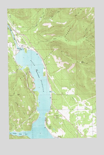
Noxon Rapids Dam, MT USGS Topographic Map
Click on map above to begin viewing in our Map Viewer.

This topographic map contains these locations and features:
Feature Name Type Latitude Longitude GNIS ID View Map
25N31W30DADD01 WellWellN47.8916°W115.6318°825167View Map
25N32W03BAAB01 WellWellN47.9597°W115.7093°825286View Map
25N32W23ACAB01 WellWellN47.9124°W115.6821°825199View Map
Bear Paw TrailTrailN47.9655°W115.6324°779558View Map
Big Cut (historical)LocaleN47.9416°W115.6977°1780974View Map
Blacktail CreekStreamN47.8997°W115.7074°780057View Map
Burr GulchValleyN47.8822°W115.7449°780656View Map
East Fork McKay CreekStreamN47.9702°W115.6421°782875View Map
Engle CreekStreamN47.9885°W115.7043°794945View Map
Engle Lake TrailTrailN47.9844°W115.6549°783204View Map
Furlong (historical)LocaleN47.9583°W115.7093°1780944View Map
Green MountainSummitN47.9477°W115.6463°784292View Map
Green Mountain TrailTrailN47.9552°W115.6705°784298View Map
Iff GulchValleyN47.8824°W115.7321°785219View Map
Marten Creek BayBayN47.8799°W115.7318°786874View Map
McKay CreekStreamN47.9594°W115.7155°787073View Map
Miller GulchValleyN47.9816°W115.7468°787421View Map
North Fork McKay CreekStreamN47.9702°W115.6421°788209View Map
Noxon Rapids DamDamN47.9608°W115.7335°788329View Map
Noxon Rapids DamDamN47.9599°W115.7343°795206View Map
Noxon Rapids ReservoirReservoirN47.9599°W115.7343°795207View Map
Rock CreekStreamN47.9749°W115.7424°789680View Map
Rock IslandIslandN47.9405°W115.7121°789700View Map
Stevens CreekStreamN47.9419°W115.7343°791498View Map
Swamp CreekStreamN47.9197°W115.6907°791766View Map
Swamp Creek DitchCanalN47.8966°W115.6282°791770View Map
TuscorPopulated PlaceN47.9033°W115.6910°792480View Map
Tuscor HillSummitN47.9166°W115.7385°792482View Map
Tuscor Post Office (historical)Post OfficeN47.8785°W115.7032°1781033View Map
Tuscor School (historical)SchoolN47.9033°W115.6910°1780830View Map

Note: Coordinates in the location and feature list above are referenced to NAD83 datum.


Copyright (C) 2008-2025 Ryan Niemi / Sunset Dynamics ... All Rights Reserved