TopoQuest Logo
Do you find TopoQuest useful?
Help keep TopoQuest running and adding new maps/features by donating!
Bitcoin:  19c7KJd3qBynnjoSw5npx9KScwjBe4ifkT
Litecoin:  LXs6TkuXGGXo1vDsWCkWVdjQX94eUKd6ui
Home View Maps Find Maps Find Places Resources & Links


Old Fields, West Virginia Topographic Map

USGS Map Title: Old Fields, WV
USGS Map MRC: 39078B8
DRG (GeoTIFF) Download: o39078b8.tif


Neighboring USGS Topographic Map Quads:


  Antioch, WV  
39079C1
 

  Burlington, WV  
39078C8
 

  Romney, WV  
39078C7
 

  Medley, WV  
39079B1
 

  Old Fields, WV  
39078B8
 

  Sector, WV  
39078B7
 

  Rig, WV  
39079A1
 

  Moorefield, WV  
39078A8
 

  Needmore, WV  
39078A7


Map MRC Location:

N40°
W79°
N40°
W78°
H8 H7 H6 H5 H4 H3 H2 H1
G8 G7 G6 G5 G4 G3 G2 G1
F8 F7 F6 F5 F4 F3 F2 F1
E8 E7 E6 E5 E4 E3 E2 E1
D8 D7 D6 D5 D4 D3 D2 D1
C8 C7 C6 C5 C4 C3 C2 C1
B8 B7 B6 B5 B4 B3 B2 B1
A8 A7 A6 A5 A4 A3 A2 A1
N39°
W79°
N39°
W78°

Old Fields, WV USGS 1:24K Topographic Map Preview:
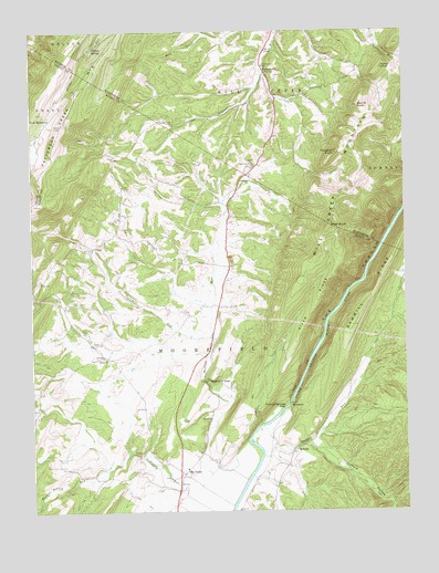
Old Fields, WV USGS Topographic Map
Click on map above to begin viewing in our Map Viewer.

This topographic map contains these locations and features:
Feature Name Type Latitude Longitude GNIS ID View Map
Anderson RunStreamN39.1354°W78.9409°1534949View Map
Bethel CemeteryCemeteryN39.1648°W78.9759°1718539View Map
Bethel ChurchChurchN39.1648°W78.9753°1535707View Map
Bethel School (historical)SchoolN39.1654°W78.9761°1556822View Map
Clifford HollowValleyN39.1426°W78.9061°1550725View Map
Elliber SpringSpringN39.2459°W78.9786°1538667View Map
Falling Springs GapGapN39.1523°W78.9150°1538866View Map
FlatsLocaleN39.1937°W78.9795°1539067View Map
Green Hill CemeteryCemeteryN39.1987°W78.9692°1539675View Map
High KnobSummitN39.1993°W78.8992°1554705View Map
High SpringSpringN39.2282°W78.9172°1677919View Map
Leslie This SpringSpringN39.2001°W78.9950°1678112View Map
Marvin ChapelChurchN39.2448°W78.9211°1542828View Map
McNeil SpringSpringN39.1384°W78.9672°1678117View Map
McNeillPopulated PlaceN39.1401°W78.9134°1549815View Map
Merritt KnobSummitN39.2304°W78.8900°1543136View Map
Mill Creek Elementary School (historical)SchoolN39.2409°W78.9220°1543333View Map
Mount View School (historical)SchoolN39.2179°W78.9681°1556856View Map
Mudlick RunStreamN39.1432°W78.9281°1543964View Map
New Lane School (historical)SchoolN39.1926°W78.9342°1556858View Map
Newbrough SpringSpringN39.1809°W78.9925°1678113View Map
Old FieldsPopulated PlaceN39.1348°W78.9497°1555262View Map
Old Fields ChurchChurchN39.1337°W78.9542°1718577View Map
Old Fields DistrictCivilN39.1460°W78.9344°1928334View Map
Old Fields Post OfficePost OfficeN39.1356°W78.9518°1718578View Map
Old Fields School (historical)SchoolN39.1362°W78.9486°1718579View Map
Old Pine CemeteryCemeteryN39.2148°W78.9259°1718687View Map
Old Pine ChurchChurchN39.2154°W78.9259°1544364View Map
Otterdin ChurchChurchN39.2109°W78.9270°1544470View Map
Patterson Creek MountainRidgeN39.2262°W78.9892°1544625View Map
Powder Lick School (historical)SchoolN39.1976°W78.9717°1556864View Map
PurgitsvillePopulated PlaceN39.2393°W78.9211°1545324View Map
Purgitsville Post OfficePost OfficeN39.2411°W78.9226°1718693View Map
Reynolds GapGapN39.1590°W78.9414°1545521View Map
River RidgeRidgeN39.1790°W78.9050°1545773View Map
Sawmill RidgeRidgeN39.1807°W78.8867°1546461View Map
South Branch Wildlife Management AreaParkN39.1468°W78.9150°2043554View Map
Stony RunStreamN39.1473°W78.9234°1547505View Map
SycamorePopulated PlaceN39.1529°W78.9142°1549949View Map
Taylor KnobSummitN39.2404°W78.8822°1555787View Map
Thrasher KnobSummitN39.2182°W78.8984°1548058View Map
Thrasher Spring School (historical)SchoolN39.1804°W78.9906°1556876View Map
Toombs HollowValleyN39.1526°W78.9981°1548173View Map
Turnmill RunStreamN39.1704°W78.9403°1548385View Map
Twin MountainLocaleN39.2257°W78.9950°1548403View Map
Walnut Bottom RunStreamN39.1362°W78.9745°1548746View Map
Welton SpringSpringN39.1487°W78.9275°1678114View Map
Welton SpringSpringN39.1479°W78.9389°1678115View Map
Welton SpringSpringN39.1401°W78.9317°1678116View Map

Note: Coordinates in the location and feature list above are referenced to NAD83 datum.


Copyright (C) 2008-2024 Ryan Niemi / Sunset Dynamics ... All Rights Reserved