TopoQuest Logo
Do you find TopoQuest useful?
Help keep TopoQuest running and adding new maps/features by donating!
Bitcoin:  19c7KJd3qBynnjoSw5npx9KScwjBe4ifkT
Litecoin:  LXs6TkuXGGXo1vDsWCkWVdjQX94eUKd6ui
Home View Maps Find Maps Find Places Resources & Links


Owl Ridge, Colorado Topographic Map

USGS Map Title: Owl Ridge, CO
USGS Map MRC: 40106E2
DRG (GeoTIFF) Download: o40106e2.tif


Neighboring USGS Topographic Map Quads:


  Walden, CO  
40106F3
 

  Gould NW, CO  
40106F2
 

  Johnny Moore Mountain, CO  
40106F1
 

  MacFarlane Reservoir, CO  
40106E3
 

  Owl Ridge, CO  
40106E2
 

  Gould, CO  
40106E1
 

  Buffalo Peak, CO  
40106D3
 

  Rand, CO  
40106D2
 

  Jack Creek Ranch, CO  
40106D1


Map MRC Location:

N41°
W107°
N41°
W106°
H8 H7 H6 H5 H4 H3 H2 H1
G8 G7 G6 G5 G4 G3 G2 G1
F8 F7 F6 F5 F4 F3 F2 F1
E8 E7 E6 E5 E4 E3 E2 E1
D8 D7 D6 D5 D4 D3 D2 D1
C8 C7 C6 C5 C4 C3 C2 C1
B8 B7 B6 B5 B4 B3 B2 B1
A8 A7 A6 A5 A4 A3 A2 A1
N40°
W107°
N40°
W106°

Owl Ridge, CO USGS 1:24K Topographic Map Preview:
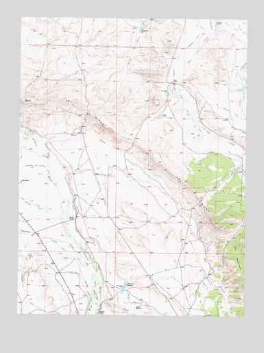
Owl Ridge, CO USGS Topographic Map
Click on map above to begin viewing in our Map Viewer.

This topographic map contains these locations and features:
Feature Name Type Latitude Longitude GNIS ID View Map
Alderdice DrawValleyN40.5958°W106.1268°172681View Map
Burr RanchLocaleN40.5555°W106.2489°172670View Map
Deer CreekStreamN40.5739°W106.2384°172680View Map
Deer DitchCanalN40.5114°W106.1464°172675View Map
First Extension Owl DitchCanalN40.5666°W106.1286°202099View Map
Howard DitchCanalN40.5230°W106.2184°172677View Map
Howard RanchLocaleN40.5008°W106.2061°202096View Map
Illinois RanchLocaleN40.5403°W106.2200°172671View Map
Indian CreekStreamN40.5089°W106.2045°172679View Map
Ish Baldwin DitchCanalN40.5769°W106.2442°172669View Map
Leonard DitchCanalN40.5032°W106.2068°2723249View Map
Lowland DitchCanalN40.6166°W106.1534°202062View Map
Mac Farlane DitchCanalN40.5166°W106.2300°202090View Map
Midland Supply DitchCanalN40.5078°W106.2072°172676View Map
Overton RanchLocaleN40.6230°W106.1431°172667View Map
Owl Mountain DitchCanalN40.5783°W106.1278°202100View Map
Owl RidgeRidgeN40.5797°W106.2042°202093View Map
Pioneer DitchCanalN40.5403°W106.2192°172674View Map
Rand ReservoirReservoirN40.5025°W106.1851°172673View Map
Ravine Ditch Number 2CanalN40.5914°W106.1274°2724162View Map
Road SpringSpringN40.5019°W106.1670°169569View Map
Shawver DamDamN40.5133°W106.1922°199994View Map
Shawver ReservoirReservoirN40.5117°W106.1919°172672View Map
Soldiers Home DitchCanalN40.5972°W106.1672°172665View Map
Thirty One ReservoirReservoirN40.6201°W106.1848°172668View Map
Troy DitchCanalN40.5805°W106.1550°2631061View Map
Vils RanchLocaleN40.5986°W106.1659°172666View Map
Willow CreekStreamN40.5183°W106.2061°172678View Map

Note: Coordinates in the location and feature list above are referenced to NAD83 datum.


Copyright (C) 2008-2024 Ryan Niemi / Sunset Dynamics ... All Rights Reserved