TopoQuest Logo
Do you find TopoQuest useful?
Help keep TopoQuest running and adding new maps/features by donating!
Bitcoin:  19c7KJd3qBynnjoSw5npx9KScwjBe4ifkT
Litecoin:  LXs6TkuXGGXo1vDsWCkWVdjQX94eUKd6ui
Home View Maps Find Maps Find Places Resources & Links


Pecks Lake, Texas Topographic Map

USGS Map Title: Pecks Lake, TX
USGS Map MRC: 31101G7
DRG (GeoTIFF) Download: o31101g7.tif


Neighboring USGS Topographic Map Quads:


  Stephenson Lake, TX  
31101H8
 

  Spraberry, TX  
31101H7
 

  Dewey Lake, TX  
31101H6
 

  Salt Lake, TX  
31101G8
 

  Pecks Lake, TX  
31101G7
 

  Patterson Lake, TX  
31101G6
 

  Midkiff NW, TX  
31101F8
 

  Midkiff, TX  
31101F7
 

  Bigby Corner, TX  
31101F6


Map MRC Location:

N32°
W102°
N32°
W101°
H8 H7 H6 H5 H4 H3 H2 H1
G8 G7 G6 G5 G4 G3 G2 G1
F8 F7 F6 F5 F4 F3 F2 F1
E8 E7 E6 E5 E4 E3 E2 E1
D8 D7 D6 D5 D4 D3 D2 D1
C8 C7 C6 C5 C4 C3 C2 C1
B8 B7 B6 B5 B4 B3 B2 B1
A8 A7 A6 A5 A4 A3 A2 A1
N31°
W102°
N31°
W101°

Pecks Lake, TX USGS 1:24K Topographic Map Preview:
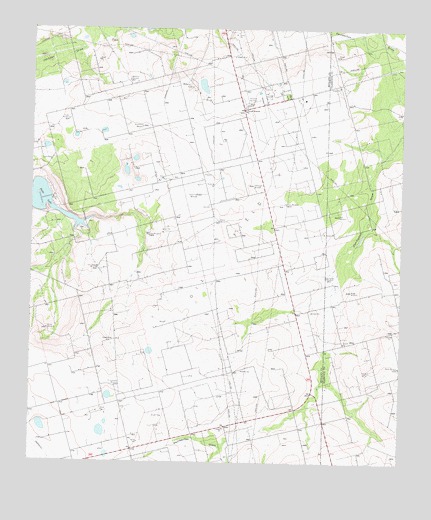
Pecks Lake, TX USGS Topographic Map
Click on map above to begin viewing in our Map Viewer.

This topographic map contains these locations and features:
Feature Name Type Latitude Longitude GNIS ID View Map
Brown WindmillLocaleN31.7882°W101.8696°1331368View Map
East WindmillLocaleN31.8212°W101.7718°1335030View Map
Farm WindmillLocaleN31.8246°W101.7896°1335706View Map
Hi Lonesome WindmillLocaleN31.7718°W101.8462°1337664View Map
Hill WindmillLocaleN31.8590°W101.8240°1337793View Map
Lake WindmillLocaleN31.8151°W101.8354°1339525View Map
Last Chance WindmillLocaleN31.8060°W101.8526°1339698View Map
Middle WindmillLocaleN31.8199°W101.8118°1341533View Map
North Pasture WindmillLocaleN31.8035°W101.7754°1342785View Map
Pecks LakeLakeN31.8250°W101.8705°1343792View Map
Pecks SpringSpringN31.8140°W101.8601°1998405View Map
Pioneer Memorial ChurchChurchN31.8515°W101.8035°1344120View Map
Shackleford WindmillLocaleN31.8465°W101.8382°1346925View Map
South WindmillLocaleN31.7779°W101.7507°1347557View Map
Spraberry Gas PlantOilfieldN31.8549°W101.7993°1347677View Map
Steel Trap WindmillLocaleN31.8274°W101.8196°1347855View Map
Thirtyeight WindmillLocaleN31.8301°W101.8007°1348475View Map
Tucker WindmillLocaleN31.8487°W101.8632°1348826View Map
Weatherd WindmillLocaleN31.8601°W101.8432°1349571View Map
Wrage WindmillLocaleN31.7996°W101.7671°1350604View Map

Note: Coordinates in the location and feature list above are referenced to NAD83 datum.


Copyright (C) 2008-2025 Ryan Niemi / Sunset Dynamics ... All Rights Reserved