TopoQuest Logo
Do you find TopoQuest useful?
Help keep TopoQuest running and adding new maps/features by donating!
Bitcoin:  19c7KJd3qBynnjoSw5npx9KScwjBe4ifkT
Litecoin:  LXs6TkuXGGXo1vDsWCkWVdjQX94eUKd6ui
Home View Maps Find Maps Find Places Resources & Links


Cantonment, Florida Topographic Map

USGS Map Title: Cantonment, FL
USGS Map MRC: 30087E3
DRG (GeoTIFF) Download: o30087e3.tif


Neighboring USGS Topographic Map Quads:


  Barrineau Park, FL  
30087F4
 

  Molino, FL  
30087F3
 

  Wallace, FL  
30087F2
 

  Seminole, AL  
30087E4
 

  Cantonment, FL  
30087E3
 

  Pace, FL  
30087E2
 

  Lillian, AL  
30087D4
 

  West Pensacola, FL  
30087D3
 

  Pensacola, FL  
30087D2


Map MRC Location:

N31°
W88°
N31°
W87°
H8 H7 H6 H5 H4 H3 H2 H1
G8 G7 G6 G5 G4 G3 G2 G1
F8 F7 F6 F5 F4 F3 F2 F1
E8 E7 E6 E5 E4 E3 E2 E1
D8 D7 D6 D5 D4 D3 D2 D1
C8 C7 C6 C5 C4 C3 C2 C1
B8 B7 B6 B5 B4 B3 B2 B1
A8 A7 A6 A5 A4 A3 A2 A1
N30°
W88°
N30°
W87°

Cantonment, FL USGS 1:24K Topographic Map Preview:
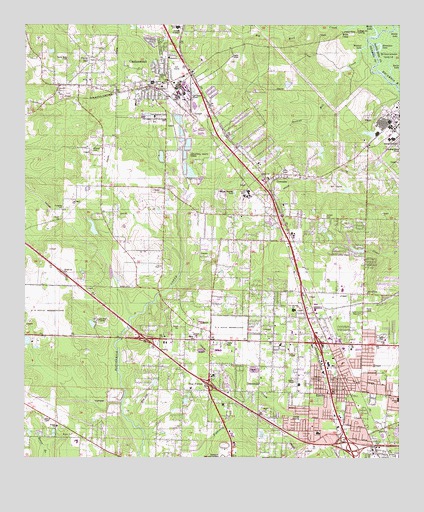
Cantonment, FL USGS Topographic Map
Click on map above to begin viewing in our Map Viewer.

This topographic map contains these locations and features:
Feature Name Type Latitude Longitude GNIS ID View Map
Becks CampLocaleN30.6230°W87.2683°278371View Map
Beulah ChurchChurchN30.5069°W87.3589°278590View Map
Big Eagle Railroad StationLocaleN30.5377°W87.2722°300220View Map
Big Rock CreekStreamN30.6244°W87.2672°278734View Map
CantonmentPopulated PlaceN30.6085°W87.3400°279994View Map
Cantonment Church of ChristChurchN30.6127°W87.3333°300459View Map
Cantonment DivisionCivilN30.5756°W87.3405°1935711View Map
Cantonment Post OfficePost OfficeN30.5835°W87.2994°2783431View Map
Cantonment Volunteer Fire Department Station 4BuildingN30.6178°W87.3256°2644328View Map
Carr ChapelChurchN30.5555°W87.3294°280063View Map
Cottage Hill LandingLocaleN30.6241°W87.2641°295221View Map
Edge Railroad StationLocaleN30.5096°W87.2711°300221View Map
EnsleyPopulated PlaceN30.5188°W87.2728°282228View Map
Ensley Census Designated PlaceCensusN30.5261°W87.2735°2402457View Map
Ensley Christian and Missionary Alliance ChurchChurchN30.5155°W87.2639°300458View Map
Ensley Memorial Baptist ChurchChurchN30.5196°W87.2736°300495View Map
Ensley SchoolSchoolN30.5169°W87.2503°282229View Map
Ensley Volunteer Fire DepartmentBuildingN30.5227°W87.2733°2643995View Map
Escambia CountyCivilN30.6144°W87.3414°295737View Map
Escambia County Sheriff's Office - Precinct 4BuildingN30.5261°W87.2725°2754532View Map
Escambia River State Wildlife Management AreaParkN30.6182°W87.2583°1985583View Map
Escambia Westgate CenterSchoolN30.5507°W87.2685°297903View Map
Farm HillPopulated PlaceN30.6138°W87.3536°282385View Map
Farm Hill ChurchChurchN30.6055°W87.3636°282386View Map
First Alliance ChurchChurchN30.5905°W87.3055°300457View Map
Full Gospel Worship CenterChurchN30.5269°W87.3105°1766223View Map
GonzalezPopulated PlaceN30.5816°W87.2914°283169View Map
Gonzalez Census Designated PlaceCensusN30.5822°W87.2906°2402537View Map
Gonzalez Post OfficePost OfficeN30.5817°W87.2924°2783395View Map
Grace Baptist ChurchChurchN30.5183°W87.2653°300507View Map
Greater First Baptist Church of CantonmentChurchN30.6155°W87.3250°300549View Map
Heritage Baptist Church CantonmentChurchN30.6030°W87.3328°300490View Map
Hillcrest Baptist ChurchChurchN30.5724°W87.2889°300489View Map
Horseshoe LakeLakeN30.6189°W87.2566°284314View Map
J M Tate Senior High SchoolSchoolN30.5766°W87.3003°292052View Map
Jim Allen Elementary SchoolSchoolN30.6241°W87.3239°277757View Map
Jordan CemeteryCemeteryN30.5699°W87.2752°284931View Map
Kinder Care Learning CenterSchoolN30.5405°W87.2797°300691View Map
L D McArthur Elementary SchoolSchoolN30.5485°W87.2672°297904View Map
Langley-Bell 4-H CenterLocaleN30.5405°W87.3514°285340View Map
Lincoln Park Elementary SchoolSchoolN30.5069°W87.2769°297902View Map
Manuel Gonzales GrantCivilN30.5969°W87.3064°304061View Map
Metropolitan ChurchChurchN30.5477°W87.2608°286743View Map
Milan De La Carrera GrantCivilN30.6044°W87.2505°304037View Map
Mission CemeteryCemeteryN30.5891°W87.3527°286987View Map
Mobile Highway Baptist ChurchChurchN30.5821°W87.2930°300487View Map
Mount Morian African Methodist Episcopal Zion ChurchChurchN30.5682°W87.2625°300580View Map
OlivePopulated PlaceN30.5088°W87.2553°295510View Map
Olive Road Church of GodChurchN30.5071°W87.2694°300570View Map
Olive SchoolSchoolN30.5074°W87.2772°288141View Map
Pensacola Baptist ChurchChurchN30.5349°W87.3139°300506View Map
Pensacola Memorial GardensCemeteryN30.5004°W87.3081°288705View Map
Philpot Fire TowerTowerN30.5121°W87.3675°300219View Map
Pine ForestPopulated PlaceN30.5196°W87.3164°288833View Map
Pine Forest Baptist ChurchChurchN30.5169°W87.3111°300484View Map
Pine Forest EstatesChurchN30.5210°W87.3194°300524View Map
Pine Meadow SchoolSchoolN30.5424°W87.2853°288911View Map
Plainview ChurchChurchN30.5330°W87.2897°289019View Map
Ransom Middle SchoolSchoolN30.5803°W87.3433°289474View Map
Santa Marie CemeteryCemeteryN30.6152°W87.3605°290659View Map
Satsuma HeightsPopulated PlaceN30.5857°W87.2689°304060View Map
Spanish Mill CreekStreamN30.6196°W87.2600°291477View Map
Spoken Word Christian SchoolSchoolN30.5352°W87.2722°300690View Map
Spreull CemeteryCemeteryN30.6110°W87.3297°291513View Map
Stubbs LakeLakeN30.6233°W87.2508°291758View Map
Waldorf LakeLakeN30.6185°W87.2621°292827View Map
Walnut Avenue ChurchChurchN30.5227°W87.2764°292849View Map
WRBK-AM (Cantonment)TowerN30.5799°W87.2883°310031View Map

Note: Coordinates in the location and feature list above are referenced to NAD83 datum.


Copyright (C) 2008-2024 Ryan Niemi / Sunset Dynamics ... All Rights Reserved