TopoQuest Logo
Do you find TopoQuest useful?
Help keep TopoQuest running and adding new maps/features by donating!
Bitcoin:  19c7KJd3qBynnjoSw5npx9KScwjBe4ifkT
Litecoin:  LXs6TkuXGGXo1vDsWCkWVdjQX94eUKd6ui
Home View Maps Find Maps Find Places Resources & Links


Pleasant Prairie, Wisconsin Topographic Map

USGS Map Title: Pleasant Prairie, WI
USGS Map MRC: 42087E8
DRG (GeoTIFF) Download: o42087e8.tif


Neighboring USGS Topographic Map Quads:


  Union Grove, WI  
42088F1
 

  Sturtevant, WI  
42087F8
 

  Racine South, WI  
42087F7
 

  Paddock Lake, WI  
42088E1
 

  Pleasant Prairie, WI  
42087E8
 

  Kenosha, WI  
42087E7
 

  Antioch, IL  
42088D1
 

  Wadsworth, IL  
42087D8
 

  Zion, IL  
42087D7


Map MRC Location:

N43°
W88°
N43°
W87°
H8 H7 H6 H5 H4 H3 H2 H1
G8 G7 G6 G5 G4 G3 G2 G1
F8 F7 F6 F5 F4 F3 F2 F1
E8 E7 E6 E5 E4 E3 E2 E1
D8 D7 D6 D5 D4 D3 D2 D1
C8 C7 C6 C5 C4 C3 C2 C1
B8 B7 B6 B5 B4 B3 B2 B1
A8 A7 A6 A5 A4 A3 A2 A1
N42°
W88°
N42°
W87°

Pleasant Prairie, WI USGS 1:24K Topographic Map Preview:
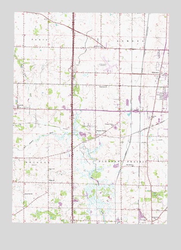
Pleasant Prairie, WI USGS Topographic Map
Click on map above to begin viewing in our Map Viewer.

This topographic map contains these locations and features:
Feature Name Type Latitude Longitude GNIS ID View Map
Aurora Medical CenterHospitalN42.5696°W87.9354°2698489View Map
Bullamore Forks SchoolSchoolN42.6045°W87.9276°1562395View Map
City of KenoshaCivilN42.5862°W87.8758°1583472View Map
D and K FarmsLocaleN42.5911°W87.9908°2712473View Map
Fenske FarmsLocaleN42.6125°W87.8967°2712470View Map
Hazel Dell SchoolSchoolN42.5172°W87.9904°1566228View Map
Horton FarmsLocaleN42.5144°W87.9828°2712464View Map
Indian Trail High School and AcademySchoolN42.5829°W87.8894°2716909View Map
Interchange 340CrossingN42.6150°W87.9522°2351454View Map
Interchange 342CrossingN42.5911°W87.9531°2351455View Map
Interchange 344CrossingN42.5675°W87.9528°2351456View Map
Interchange 345CrossingN42.5436°W87.9525°2351457View Map
Interchange 347CrossingN42.5236°W87.9522°2351458View Map
Jerome CreekStreamN42.5317°W87.9334°1567161View Map
Kenosha County CemeteryCemeteryN42.5484°W87.9132°1998791View Map
Kenosha Fire Department Station 7BuildingN42.5901°W87.9259°2698111View Map
Kenosha House of Corrections - Phoenix Project SchoolSchoolN42.5931°W87.9135°2716593View Map
Kenosha Regional AirportAirportN42.5941°W87.9282°1582034View Map
Kilbourn Road DitchCanalN42.5956°W87.9479°1567469View Map
Lakeview Technology AcademySchoolN42.5363°W87.9123°2716195View Map
Lincoln SchoolSchoolN42.5636°W87.8884°1568087View Map
Mahone Middle SchoolSchoolN42.5844°W87.8939°2716702View Map
Nash Elementary SchoolSchoolN42.5735°W87.9268°2716592View Map
North Bristol CemeteryCemeteryN42.5681°W87.9922°1570402View Map
Paratech Ambulance Service Kenosha DivisionBuildingN42.5648°W87.8766°2698431View Map
Pleasant LakeLakeN42.5169°W87.9398°2764465View Map
Pleasant PrairiePopulated PlaceN42.5531°W87.9334°1571621View Map
Pleasant Prairie Elementary SchoolSchoolN42.5592°W87.9193°1571624View Map
Pleasant Prairie Fire and Rescue Station 2BuildingN42.5584°W87.9146°2697514View Map
Pleasant Prairie Mobile Home CourtPopulated PlaceN42.5817°W87.9508°2508203View Map
Pleasant Prairie Police DepartmentBuildingN42.5507°W87.8933°2759512View Map
Pleasant Prairie Power PlantBuildingN42.5381°W87.9047°2392412View Map
Prairie Lake EstatesPopulated PlaceN42.5689°W87.9072°2508192View Map
River Oaks LakeLakeN42.5529°W87.9439°2764466View Map
Root RiverStreamN42.5539°W87.9573°1572588View Map
Saint Catherines Medical Center CampusHospitalN42.5647°W87.9244°2698494View Map
South Bristol CemeteryCemeteryN42.5321°W87.9708°1574422View Map
Spring Brook CemeteryCemeteryN42.5027°W87.8921°1574602View Map
Spring Brook SchoolSchoolN42.5031°W87.8842°1574604View Map
Star Harmony SchoolSchoolN42.5345°W87.9026°1574804View Map
Stephenson SchoolSchoolN42.5817°W87.9306°1574864View Map
Stocker Elementary SchoolSchoolN42.5729°W87.8839°2716910View Map
Sunset Ridge Memorial Park CemeteryCemeteryN42.6009°W87.8834°1575120View Map
Thompson Strawberry Farm Airport (historical)AirportN42.5722°W87.9779°1581899View Map
Town of SomersCivilN42.6020°W87.8949°1584173View Map
TruesdellPopulated PlaceN42.5667°W87.9012°1577858View Map
Vale CemeteryCemeteryN42.5674°W87.9244°1998796View Map
Village of Pleasant PrairieCivilN42.5265°W87.8894°1583935View Map
Wesley ChurchChurchN42.5253°W87.9709°1576433View Map
Westwood EstatesPopulated PlaceN42.5617°W87.9083°2508189View Map
WHKE-TV (Kenosha)TowerN42.5100°W87.8865°1582502View Map
WJZQ-FM (Kenosha)TowerN42.5528°W87.8940°1582393View Map
WLIP-AM (Kenosha)TowerN42.5528°W87.8940°1582309View Map
Woodworth SchoolSchoolN42.5684°W87.9965°1577044View Map

Note: Coordinates in the location and feature list above are referenced to NAD83 datum.


Copyright (C) 2008-2025 Ryan Niemi / Sunset Dynamics ... All Rights Reserved