TopoQuest Logo
Do you find TopoQuest useful?
Help keep TopoQuest running and adding new maps/features by donating!
Bitcoin:  19c7KJd3qBynnjoSw5npx9KScwjBe4ifkT
Litecoin:  LXs6TkuXGGXo1vDsWCkWVdjQX94eUKd6ui
Home View Maps Find Maps Find Places Resources & Links


Quanah East, Texas Topographic Map

USGS Map Title: Quanah East, TX
USGS Map MRC: 34099C6
DRG (GeoTIFF) Download: o34099c6.tif


Neighboring USGS Topographic Map Quads:


  North Groesbeck, TX  
34099D7
 

  Eldorado, OK  
34099D6
 

  Quanah NE, OK  
34099D5
 

  Quanah West, TX  
34099C7
 

  Quanah East, TX  
34099C6
 

  Chillicothe, TX  
34099C5
 

  Maybell Canyon, TX  
34099B7
 

  Big Mound, TX  
34099B6
 

  Medicine Mound, TX  
34099B5


Map MRC Location:

N35°
W100°
N35°
W99°
H8 H7 H6 H5 H4 H3 H2 H1
G8 G7 G6 G5 G4 G3 G2 G1
F8 F7 F6 F5 F4 F3 F2 F1
E8 E7 E6 E5 E4 E3 E2 E1
D8 D7 D6 D5 D4 D3 D2 D1
C8 C7 C6 C5 C4 C3 C2 C1
B8 B7 B6 B5 B4 B3 B2 B1
A8 A7 A6 A5 A4 A3 A2 A1
N34°
W100°
N34°
W99°

Quanah East, TX USGS 1:24K Topographic Map Preview:
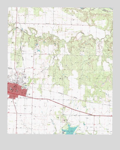
Quanah East, TX USGS Topographic Map
Click on map above to begin viewing in our Map Viewer.

This topographic map contains these locations and features:
Feature Name Type Latitude Longitude GNIS ID View Map
Church of ChristChurchN34.3076°W99.7381°2019444View Map
Church of the NazareneChurchN34.2940°W99.7418°2019446View Map
City of QuanahCivilN34.2954°W99.7429°2411505View Map
City of Quanah LakeReservoirN34.2975°W99.7286°1864483View Map
City of Quanah Lake DamDamN34.2984°W99.7287°1864482View Map
Conley Oil FieldOilfieldN34.2573°W99.6440°1889677View Map
First Baptist ChurchChurchN34.2934°W99.7395°2019441View Map
Flat TopSummitN34.2637°W99.6837°1357452View Map
Hardeman CountyCivilN34.2903°W99.7457°1383884View Map
Hardeman County Constable's Office Precinct 4BuildingN34.2973°W99.7411°2750594View Map
Hardeman County Emergency Medical Services QuanahBuildingN34.2983°W99.7410°2655789View Map
Hardeman County Historical MuseumBuildingN34.2992°W99.7412°2014093View Map
Hardeman County JailBuildingN34.2973°W99.7403°2738826View Map
Hardeman County Memorial HospitalHospitalN34.2967°W99.7414°2015841View Map
Hardeman County Sheriff's OfficeBuildingN34.2972°W99.7411°2750420View Map
KIXC-AM (Quanah)TowerN34.3162°W99.7473°1385667View Map
KIXC-FM (Quanah)TowerN34.3162°W99.7473°1385977View Map
Lake Pauline DamDamN34.2501°W99.6720°1861759View Map
Lake Pauline PowerplantLocaleN34.2523°W99.6829°1384590View Map
Memorial Park CemeteryCemeteryN34.3062°W99.7301°1890000View Map
QuanahPopulated PlaceN34.2979°W99.7404°1365885View Map
Quanah Acme and Pacific DepotLocaleN34.2873°W99.7481°2032054View Map
Quanah City HallBuildingN34.2987°W99.7379°2753892View Map
Quanah Country ClubLocaleN34.3345°W99.7151°1384651View Map
Quanah Country Club North LakeReservoirN34.3372°W99.7151°1864485View Map
Quanah Country Club North Lake DamDamN34.3401°W99.7154°1864484View Map
Quanah Country Club South LakeReservoirN34.3322°W99.7133°1864487View Map
Quanah Country Club South Lake DamDamN34.3334°W99.7137°1864486View Map
Quanah DivisionCivilN34.2676°W99.7306°1939113View Map
Quanah Fire DepartmentBuildingN34.2987°W99.7379°2552085View Map
Quanah High SchoolSchoolN34.2945°W99.7454°2005394View Map
Quanah Municipal Water WellsWellN34.3581°W99.6895°1365886View Map
Quanah Police DepartmentBuildingN34.2982°W99.7409°2750413View Map
Quanah Post OfficePost OfficeN34.2978°W99.7415°2732273View Map
Reagan Elementary SchoolSchoolN34.2926°W99.7401°2005395View Map
Reagan SchoolSchoolN34.2929°W99.7393°1366087View Map
Spring CreekStreamN34.3420°W99.6834°1368967View Map
Travis Junior High SchoolSchoolN34.2948°W99.7465°2005396View Map
Travis SchoolSchoolN34.2956°W99.7462°1370091View Map
Trinity Baptist ChurchChurchN34.2887°W99.7373°2019443View Map
WillowviewPopulated PlaceN34.3584°W99.7054°1380788View Map

Note: Coordinates in the location and feature list above are referenced to NAD83 datum.


Copyright (C) 2008-2025 Ryan Niemi / Sunset Dynamics ... All Rights Reserved