TopoQuest Logo
Do you find TopoQuest useful?
Help keep TopoQuest running and adding new maps/features by donating!
Bitcoin:  19c7KJd3qBynnjoSw5npx9KScwjBe4ifkT
Litecoin:  LXs6TkuXGGXo1vDsWCkWVdjQX94eUKd6ui
Home View Maps Find Maps Find Places Resources & Links


Queen City, Missouri Topographic Map

USGS Map Title: Queen City, MO
USGS Map MRC: 40092D5
DRG (GeoTIFF) Download: o40092d5.tif


Neighboring USGS Topographic Map Quads:


  Coatsville, MO  
40092E6
 

  Lancaster, MO  
40092E5
 

  Bunker Hill, MO  
40092E4
 

  Livonia, MO  
40092D6
 

  Queen City, MO  
40092D5
 

  Downing NW, MO  
40092D4
 

  Connelsville, MO  
40092C6
 

  Greentop, MO  
40092C5
 

  Willmathsville, MO  
40092C4


Map MRC Location:

N41°
W93°
N41°
W92°
H8 H7 H6 H5 H4 H3 H2 H1
G8 G7 G6 G5 G4 G3 G2 G1
F8 F7 F6 F5 F4 F3 F2 F1
E8 E7 E6 E5 E4 E3 E2 E1
D8 D7 D6 D5 D4 D3 D2 D1
C8 C7 C6 C5 C4 C3 C2 C1
B8 B7 B6 B5 B4 B3 B2 B1
A8 A7 A6 A5 A4 A3 A2 A1
N40°
W93°
N40°
W92°

Queen City, MO USGS 1:24K Topographic Map Preview:
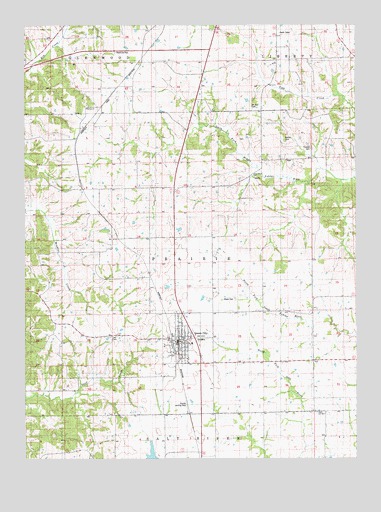
Queen City, MO USGS Topographic Map
Click on map above to begin viewing in our Map Viewer.

This topographic map contains these locations and features:
Feature Name Type Latitude Longitude GNIS ID View Map
Applegate AirportAirportN40.3886°W92.5644°742867View Map
Barnes CemeteryCemeteryN40.4672°W92.5280°713671View Map
Barr School (historical)SchoolN40.4034°W92.5010°741585View Map
Bethel ChurchChurchN40.4761°W92.6024°714079View Map
Blacks School (historical)SchoolN40.4281°W92.5349°741586View Map
City of Queen CityCivilN40.4126°W92.5663°2396298View Map
Green Valley School (historical)SchoolN40.3878°W92.5732°741584View Map
Independence School (historical)SchoolN40.4889°W92.6244°741590View Map
JulesburgPopulated PlaceN40.4617°W92.6060°738035View Map
Liberty Hall SchoolSchoolN40.4917°W92.5955°741591View Map
Lucas School (historical)SchoolN40.4939°W92.5563°741592View Map
Mount Zion CemeteryCemeteryN40.4759°W92.5399°722941View Map
Myers CemeteryCemeteryN40.4209°W92.5463°723099View Map
New Hope ChurchChurchN40.4570°W92.5396°723263View Map
New Hope SchoolSchoolN40.4606°W92.5369°741587View Map
Patterson School (historical)SchoolN40.4086°W92.6094°741583View Map
Public Water Supply District 1 L ReservoirReservoirN40.3758°W92.5775°760493View Map
Queen CityPopulated PlaceN40.4092°W92.5677°725021View Map
Queen City CemeteryCemeteryN40.4095°W92.5583°2702927View Map
Queen City Community Fire DepartmentBuildingN40.4090°W92.5680°2621565View Map
Queen City Municipal Airport (historical)AirportN40.3920°W92.5655°758883View Map
Queen City Post OfficePost OfficeN40.4077°W92.5671°2782878View Map
Roberts School (historical)SchoolN40.4517°W92.6066°741589View Map
School Number Thirty-fourSchoolN40.4036°W92.5349°741610View Map
Schuyler CountyCivilN40.4703°W92.5209°758551View Map
Tarr CemeteryCemeteryN40.4097°W92.5930°754142View Map
Thomas CemeteryCemeteryN40.4645°W92.5174°727582View Map
Tipton School (historical)SchoolN40.4520°W92.5738°741588View Map
Township of PrairieCivilN40.4325°W92.5808°767373View Map

Note: Coordinates in the location and feature list above are referenced to NAD83 datum.


Copyright (C) 2008-2024 Ryan Niemi / Sunset Dynamics ... All Rights Reserved