TopoQuest Logo
Do you find TopoQuest useful?
Help keep TopoQuest running and adding new maps/features by donating!
Bitcoin:  19c7KJd3qBynnjoSw5npx9KScwjBe4ifkT
Litecoin:  LXs6TkuXGGXo1vDsWCkWVdjQX94eUKd6ui
Home View Maps Find Maps Find Places Resources & Links


Canyon Day, Arizona Topographic Map

USGS Map Title: Canyon Day, AZ
USGS Map MRC: 33110G1
DRG (GeoTIFF) Download: o33110g1.tif


Neighboring USGS Topographic Map Quads:


  Cedar Creek, AZ  
33110H2
 

  Round Top Mountain, AZ  
33110H1
 

  Alchesay Flat, AZ  
33109H8
 

  Cone Butte, AZ  
33110G2
 

  Canyon Day, AZ  
33110G1
 

  Whiteriver, AZ  
33109G8
 

  Forks Butte, AZ  
33110F2
 

  Velasquez Butte, AZ  
33110F1
 

  Bonito Prairie, AZ  
33109F8


Map MRC Location:

N34°
W111°
N34°
W110°
H8 H7 H6 H5 H4 H3 H2 H1
G8 G7 G6 G5 G4 G3 G2 G1
F8 F7 F6 F5 F4 F3 F2 F1
E8 E7 E6 E5 E4 E3 E2 E1
D8 D7 D6 D5 D4 D3 D2 D1
C8 C7 C6 C5 C4 C3 C2 C1
B8 B7 B6 B5 B4 B3 B2 B1
A8 A7 A6 A5 A4 A3 A2 A1
N33°
W111°
N33°
W110°

Canyon Day, AZ USGS 1:24K Topographic Map Preview:
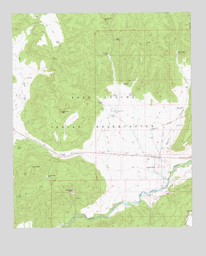
Canyon Day, AZ USGS Topographic Map
Click on map above to begin viewing in our Map Viewer.

This topographic map contains these locations and features:
Feature Name Type Latitude Longitude GNIS ID View Map
Amos SpringSpringN33.7976°W110.1201°632View Map
Amos TankReservoirN33.8376°W110.1162°634View Map
Bear CanyonValleyN33.7814°W110.0148°1114View Map
Bear Canyon Number OneReservoirN33.8190°W110.0068°1119View Map
Bear Canyon TankReservoirN33.8515°W110.0101°1118View Map
Canyon DayPopulated PlaceN33.7848°W110.0265°2435View Map
Canyon Day Census Designated PlaceCensusN33.7826°W110.0328°2407956View Map
Canyon Day Junior High SchoolSchoolN33.7777°W110.0307°2543533View Map
Canyon Day TankReservoirN33.8067°W110.0294°2436View Map
Cedar Gap TankReservoirN33.7923°W110.0890°2623View Map
Coyote SpringSpringN33.8589°W110.0501°3492View Map
D-five SpringSpringN33.8489°W110.0968°3677View Map
D-five TankReservoirN33.8733°W110.1070°3678View Map
Fort Apache JunctionPopulated PlaceN33.7898°W110.0018°4742View Map
G-one WellWellN33.8017°W110.0276°4889View Map
Ghost TankReservoirN33.8583°W110.0923°5000View Map
Kelly ButteSummitN33.7853°W110.1118°6649View Map
Kinishba TankReservoirN33.8508°W110.0583°6710View Map
Kinishba WellWellN33.8176°W110.0529°6711View Map
Macklin WellWellN33.8089°W110.0109°7574View Map
Ruins TankReservoirN33.8271°W110.0524°10591View Map
Ruins Tank Number TwoReservoirN33.8282°W110.0438°10592View Map
Sawtooth MountainSummitN33.8176°W110.0907°10988View Map
Sawtooth TankReservoirN33.8229°W110.0628°10991View Map
Sawtooth Tank Number TwoReservoirN33.8341°W110.0484°10992View Map
Sore SpringSpringN33.7684°W110.1201°11559View Map
Standing Rock TankReservoirN33.7803°W110.1019°11776View Map
Stockman StationLocaleN33.7689°W110.0295°11854View Map
Tsay-se-zhin ButteSummitN33.7717°W110.0840°12754View Map
Yellow Jacket SpringSpringN33.8714°W110.0604°14055View Map

Note: Coordinates in the location and feature list above are referenced to NAD83 datum.


Copyright (C) 2008-2024 Ryan Niemi / Sunset Dynamics ... All Rights Reserved