TopoQuest Logo
Do you find TopoQuest useful?
Help keep TopoQuest running and adding new maps/features by donating!
Bitcoin:  19c7KJd3qBynnjoSw5npx9KScwjBe4ifkT
Litecoin:  LXs6TkuXGGXo1vDsWCkWVdjQX94eUKd6ui
Home View Maps Find Maps Find Places Resources & Links


Red Creek, Colorado Topographic Map

USGS Map Title: Red Creek, CO
USGS Map MRC: 39106D7
DRG (GeoTIFF) Download: o39106d7.tif


Neighboring USGS Topographic Map Quads:


  Suicide Mountain, CO  
39106E8
 

  The Seven Hermits, CO  
39106E7
 

  Fulford, CO  
39106E6
 

  Toner Reservoir, CO  
39106D8
 

  Red Creek, CO  
39106D7
 

  Crooked Creek Pass, CO  
39106D6
 

  Woody Creek, CO  
39106C8
 

  Ruedi Reservoir, CO  
39106C7
 

  Meredith, CO  
39106C6


Map MRC Location:

N40°
W107°
N40°
W106°
H8 H7 H6 H5 H4 H3 H2 H1
G8 G7 G6 G5 G4 G3 G2 G1
F8 F7 F6 F5 F4 F3 F2 F1
E8 E7 E6 E5 E4 E3 E2 E1
D8 D7 D6 D5 D4 D3 D2 D1
C8 C7 C6 C5 C4 C3 C2 C1
B8 B7 B6 B5 B4 B3 B2 B1
A8 A7 A6 A5 A4 A3 A2 A1
N39°
W107°
N39°
W106°

Red Creek, CO USGS 1:24K Topographic Map Preview:
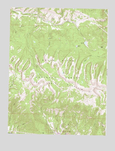
Red Creek, CO USGS Topographic Map
Click on map above to begin viewing in our Map Viewer.

This topographic map contains these locations and features:
Feature Name Type Latitude Longitude GNIS ID View Map
Alkali GulchValleyN39.4919°W106.7502°179418View Map
Alldred SpringSpringN39.4893°W106.8220°179416View Map
Antones SpringSpringN39.4622°W106.7587°179423View Map
Bagley CreekStreamN39.3794°W106.8050°179435View Map
Basalt DivisionCivilN39.4211°W106.8527°1935404View Map
Bear GulchValleyN39.4829°W106.8196°176011View Map
Bear GulchValleyN39.4974°W106.7534°176079View Map
Campbell CreekStreamN39.4864°W106.8267°179420View Map
Dry GulchValleyN39.4937°W106.8416°176013View Map
Dry GulchValleyN39.3762°W106.8137°179437View Map
Fence GulchValleyN39.4948°W106.8600°176014View Map
Frenchman CreekStreamN39.3755°W106.8745°179436View Map
Gyp HillSummitN39.3783°W106.7975°179429View Map
Hells HoleStreamN39.4953°W106.8098°176012View Map
LEDE DamDamN39.4667°W106.7783°199876View Map
LEDE ReservoirReservoirN39.4658°W106.7784°179422View Map
LEDE Reservoir CampgroundLocaleN39.4692°W106.7767°197219View Map
Lost LakeLakeN39.4359°W106.8067°179424View Map
Muckey LakeLakeN39.4814°W106.8615°179414View Map
Ragged LakesLakeN39.4628°W106.7920°179434View Map
Red CreekStreamN39.4900°W106.8359°179419View Map
Red Creek CampgroundLocaleN39.4939°W106.8414°179415View Map
Red HillSummitN39.3764°W106.8320°179426View Map
Red Table MountainSummitN39.4180°W106.7711°175987View Map
Rock LakeLakeN39.4700°W106.8251°179421View Map
Schoolhouse GulchValleyN39.4972°W106.8701°176015View Map
White CreekStreamN39.4964°W106.8670°179433View Map

Note: Coordinates in the location and feature list above are referenced to NAD83 datum.


Copyright (C) 2008-2025 Ryan Niemi / Sunset Dynamics ... All Rights Reserved