TopoQuest Logo
Do you find TopoQuest useful?
Help keep TopoQuest running and adding new maps/features by donating!
Bitcoin:  19c7KJd3qBynnjoSw5npx9KScwjBe4ifkT
Litecoin:  LXs6TkuXGGXo1vDsWCkWVdjQX94eUKd6ui
Home View Maps Find Maps Find Places Resources & Links


Sedalia West, Missouri Topographic Map

USGS Map Title: Sedalia West, MO
USGS Map MRC: 38093F3
DRG (GeoTIFF) Download: o38093f3.tif


Neighboring USGS Topographic Map Quads:


  La Monte, MO  
38093G4
 

  Hughesville, MO  
38093G3
 

  Beaman, MO  
38093G2
 

  Green Ridge North, MO  
38093F4
 

  Sedalia West, MO  
38093F3
 

  Sedalia East, MO  
38093F2
 

  Green Ridge South, MO  
38093E4
 

  Ionia, MO  
38093E3
 

  Bahner, MO  
38093E2


Map MRC Location:

N39°
W94°
N39°
W93°
H8 H7 H6 H5 H4 H3 H2 H1
G8 G7 G6 G5 G4 G3 G2 G1
F8 F7 F6 F5 F4 F3 F2 F1
E8 E7 E6 E5 E4 E3 E2 E1
D8 D7 D6 D5 D4 D3 D2 D1
C8 C7 C6 C5 C4 C3 C2 C1
B8 B7 B6 B5 B4 B3 B2 B1
A8 A7 A6 A5 A4 A3 A2 A1
N38°
W94°
N38°
W93°

Sedalia West, MO USGS 1:24K Topographic Map Preview:
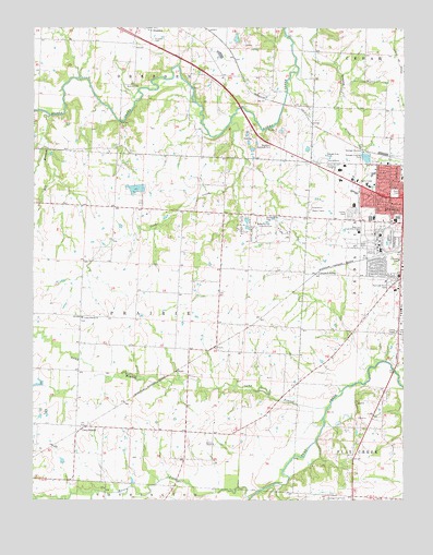
Sedalia West, MO USGS Topographic Map
Click on map above to begin viewing in our Map Viewer.

This topographic map contains these locations and features:
Feature Name Type Latitude Longitude GNIS ID View Map
Anderson School (historical)SchoolN38.6259°W93.2683°745422View Map
Basin ForkStreamN38.6259°W93.3027°713714View Map
Bradford Roadside ParkParkN38.7189°W93.2949°714613View Map
Brown School (historical)SchoolN38.7167°W93.3385°745418View Map
Camp BranchLocaleN38.6447°W93.3608°715242View Map
Camp BranchStreamN38.6495°W93.2758°715249View Map
Camp Branch ChurchChurchN38.6733°W93.3588°715253View Map
Camp Branch School (historical)SchoolN38.6525°W93.3227°745421View Map
Campbell SidingLocaleN38.6850°W93.2797°715314View Map
Coon CreekStreamN38.7250°W93.3085°716243View Map
Department of Conservation Kansas City Regional Field Fire Office SedaliaBuildingN38.6942°W93.2512°2620699View Map
Dresden CemeteryCemeteryN38.7469°W93.3352°717049View Map
E W Thompson School for the HandicappedSchoolN38.6997°W93.2659°2545428View Map
Elk BranchStreamN38.7267°W93.3699°717448View Map
Glover School (historical)SchoolN38.6736°W93.3502°745420View Map
High Point School (historical)SchoolN38.6831°W93.2508°745423View Map
Homan FieldAirportN38.6644°W93.3325°2679385View Map
KDRO-AM (Sedalia)TowerN38.7092°W93.2649°759264View Map
KMOS-TV (Sedalia)TowerN38.7464°W93.2752°759296View Map
Lake LucilleReservoirN38.7075°W93.3405°763043View Map
McKee ChapelChurchN38.6400°W93.3144°722135View Map
Memorial Park CemeteryCemeteryN38.6825°W93.2544°722223View Map
Oak Grove School (historical)SchoolN38.7245°W93.2819°745425View Map
Parkhurst Lake DamDamN38.7083°W93.3419°763042View Map
Pettis CountyCivilN38.7283°W93.2851°758534View Map
Pettis County Elementary SchoolSchoolN38.7490°W93.3365°2545232View Map
Pettis County Fire Protection District Station 1BuildingN38.6982°W93.2649°2620351View Map
Quisenberry CemeteryCemeteryN38.6996°W93.2970°725027View Map
Quisenberry School (historical)SchoolN38.6950°W93.3116°745424View Map
Sedalia Fire Department Headquarters StationBuildingN38.6993°W93.2590°2621076View Map
Skyline Elementary SchoolSchoolN38.6832°W93.2578°2545097View Map
State Fair Community CollegeSchoolN38.6975°W93.2682°727038View Map
State Fair Shopping CenterLocaleN38.6992°W93.2530°742502View Map
State Fairground RacetrackParkN38.6933°W93.2569°737851View Map
Thompson Hills Shopping CenterLocaleN38.7083°W93.2655°742501View Map
Township of PrairieCivilN38.6729°W93.3401°767172View Map
Van Natta School (historical)SchoolN38.7039°W93.3747°745419View Map
Walnut Hill Country ClubLocaleN38.6981°W93.2997°755445View Map

Note: Coordinates in the location and feature list above are referenced to NAD83 datum.


Copyright (C) 2008-2025 Ryan Niemi / Sunset Dynamics ... All Rights Reserved