TopoQuest Logo
Do you find TopoQuest useful?
Help keep TopoQuest running and adding new maps/features by donating!
Bitcoin:  19c7KJd3qBynnjoSw5npx9KScwjBe4ifkT
Litecoin:  LXs6TkuXGGXo1vDsWCkWVdjQX94eUKd6ui
Home View Maps Find Maps Find Places Resources & Links


Shafer Basin, Utah Topographic Map

USGS Map Title: Shafer Basin, UT
USGS Map MRC: 38109D6
DRG (GeoTIFF) Download: o38109d6.tif


Neighboring USGS Topographic Map Quads:


  The Knoll, UT  
38109E7
 

  Gold Bar Canyon, UT  
38109E6
 

  Moab, UT  
38109E5
 

  Musselman Arch, UT  
38109D7
 

  Shafer Basin, UT  
38109D6
 

  Trough Springs Canyon, UT  
38109D5
 

  Monument Basin, UT  
38109C7
 

  Lockhart Basin, UT  
38109C6
 

  Eightmile Rock, UT  
38109C5


Map MRC Location:

N39°
W110°
N39°
W109°
H8 H7 H6 H5 H4 H3 H2 H1
G8 G7 G6 G5 G4 G3 G2 G1
F8 F7 F6 F5 F4 F3 F2 F1
E8 E7 E6 E5 E4 E3 E2 E1
D8 D7 D6 D5 D4 D3 D2 D1
C8 C7 C6 C5 C4 C3 C2 C1
B8 B7 B6 B5 B4 B3 B2 B1
A8 A7 A6 A5 A4 A3 A2 A1
N38°
W110°
N38°
W109°

Shafer Basin, UT USGS 1:24K Topographic Map Preview:
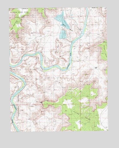
Shafer Basin, UT USGS Topographic Map
Click on map above to begin viewing in our Map Viewer.

This topographic map contains these locations and features:
Feature Name Type Latitude Longitude GNIS ID View Map
Anticline CampgroundLocaleN38.4644°W109.6271°1435063View Map
Anticline OverlookLocaleN38.4644°W109.6271°1450233View Map
Canyonlands OverlookLocaleN38.4044°W109.7090°1435248View Map
Caveman Ranch AirportAirportN38.4728°W109.6600°2443211View Map
Coffee Pot RuinsLocaleN38.3855°W109.7446°1435330View Map
Dead Horse PointCapeN38.4844°W109.7404°1427244View Map
Dead Horse Point CampgroundLocaleN38.4930°W109.7390°1435391View Map
Dead Horse Point OverlookLocaleN38.4780°W109.7396°1435392View Map
Dead Horse Point State Park Visitor CenterLocaleN38.4878°W109.7357°1435393View Map
Dripping SpringSpringN38.4386°W109.6419°1427488View Map
Frank Shafer Number 1 Oil WellLocaleN38.4947°W109.6521°1435552View Map
Hurrah PassGapN38.4825°W109.6251°1428950View Map
J H Shafer Number 1 OilwellLocaleN38.4542°W109.7246°1435751View Map
Little Bridge CanyonValleyN38.4069°W109.7498°1434922View Map
Musselman CanyonValleyN38.4284°W109.7376°1434925View Map
Pyramid ButteSummitN38.4546°W109.6910°1436180View Map
Shafer BasinBasinN38.4855°W109.6612°1432349View Map
TexasGulf Potash Pond One AReservoirN38.4894°W109.6901°1434699View Map
TexasGulf Potash Pond One A DamDamN38.4883°W109.6907°1434700View Map
TexasGulf Potash Pond Three AReservoirN38.4734°W109.6841°1434689View Map
TexasGulf Potash Pond Three A DamDamN38.4733°W109.6840°1434690View Map
TexasGulf Potash Pond Three BReservoirN38.4730°W109.6820°1434687View Map
TexasGulf Potash Pond Three B DamDamN38.4733°W109.6823°1434688View Map
TexasGulf Potash Pond Two GReservoirN38.4834°W109.6825°1434697View Map
TexasGulf Potash Pond Two G DamDamN38.4850°W109.6840°1434698View Map
TexasGulf Potash Pond Two NReservoirN38.4801°W109.6776°1434691View Map
TexasGulf Potash Pond Two N DamDamN38.4783°W109.6757°1434692View Map
United Nations Tablet (not official)SummitN38.3950°W109.7107°1451371View Map

Note: Coordinates in the location and feature list above are referenced to NAD83 datum.


Copyright (C) 2008-2025 Ryan Niemi / Sunset Dynamics ... All Rights Reserved