TopoQuest Logo
Do you find TopoQuest useful?
Help keep TopoQuest running and adding new maps/features by donating!
Bitcoin:  19c7KJd3qBynnjoSw5npx9KScwjBe4ifkT
Litecoin:  LXs6TkuXGGXo1vDsWCkWVdjQX94eUKd6ui
Home View Maps Find Maps Find Places Resources & Links


Sulphur, Nevada Topographic Map

USGS Map Title: Sulphur, NV
USGS Map MRC: 40118G6
DRG (GeoTIFF) Download: o40118g6.tif


Neighboring USGS Topographic Map Quads:


  Rabbithole NE, NV  
40118H7
 

  Floka, NV  
40118H6
 

  Sugarloaf Knob, NV  
40118H5
 

  Rabbithole, NV  
40118G7
 

  Sulphur, NV  
40118G6
 

  Sawtooth Knob, NV  
40118G5
 

  Dead Horse Canyon NE, NV  
40118F7
 

  Placerites, NV  
40118F6
 

  Scossa, NV  
40118F5


Map MRC Location:

N41°
W119°
N41°
W118°
H8 H7 H6 H5 H4 H3 H2 H1
G8 G7 G6 G5 G4 G3 G2 G1
F8 F7 F6 F5 F4 F3 F2 F1
E8 E7 E6 E5 E4 E3 E2 E1
D8 D7 D6 D5 D4 D3 D2 D1
C8 C7 C6 C5 C4 C3 C2 C1
B8 B7 B6 B5 B4 B3 B2 B1
A8 A7 A6 A5 A4 A3 A2 A1
N40°
W119°
N40°
W118°

Sulphur, NV USGS 1:24K Topographic Map Preview:
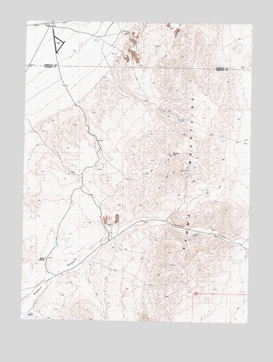
Sulphur, NV USGS Topographic Map
Click on map above to begin viewing in our Map Viewer.

This topographic map contains these locations and features:
Feature Name Type Latitude Longitude GNIS ID View Map
Abe Lincoln MineMineN40.8113°W118.6593°853864View Map
Barrell SpringsLocaleN40.7749°W118.7371°850264View Map
Brown Palace MineMineN40.8113°W118.6593°853860View Map
Constant Minerals Separation Company MinesMineN40.8118°W118.7257°853870View Map
Double O MineMineN40.7738°W118.7324°847169View Map
Dreamland MineMineN40.8113°W118.6593°853861View Map
Durango Girl MineMineN40.8113°W118.6593°853862View Map
Goldbud (historical)Populated PlaceN40.7921°W118.6715°846109View Map
Grubstake MineMineN40.8113°W118.6593°853863View Map
H and M Number 1 MineMineN40.7841°W118.6304°846119View Map
Kamma MountainsRangeN40.7707°W118.6649°847180View Map
Lander SpringSpringN40.7651°W118.6815°857324View Map
Rabbit Hole Mining DistrictCivilN40.8118°W118.7257°853871View Map
Rosebud (historical)Populated PlaceN40.8002°W118.6618°846104View Map
Rosebud CanyonValleyN40.7910°W118.6896°843365View Map
Rosebud MineMineN40.8130°W118.6618°850262View Map
Rosebud Mining DistrictCivilN40.8205°W118.6549°853869View Map
Rosebud PeakSummitN40.8196°W118.6702°843367View Map
Rosebud Post Office (historical)Post OfficeN40.8002°W118.6618°864387View Map
Rosebud SpringSpringN40.7863°W118.6572°850263View Map
Silver Camel MineMineN40.8124°W118.7227°855077View Map
SulphurPopulated PlaceN40.8746°W118.7366°845687View Map
Sulphur Airport (historical)AirportN40.8676°W118.7333°855238View Map
Sulphur MineMineN40.8677°W118.6921°846105View Map
Sulphur Post Office (historical)Post OfficeN40.8746°W118.7366°864862View Map
Sulphur SpringsSpringN40.8677°W118.7104°850260View Map
Wild Rose SpringSpringN40.8347°W118.6622°850261View Map

Note: Coordinates in the location and feature list above are referenced to NAD83 datum.


Copyright (C) 2008-2025 Ryan Niemi / Sunset Dynamics ... All Rights Reserved