TopoQuest Logo
Do you find TopoQuest useful?
Help keep TopoQuest running and adding new maps/features by donating!
Bitcoin:  19c7KJd3qBynnjoSw5npx9KScwjBe4ifkT
Litecoin:  LXs6TkuXGGXo1vDsWCkWVdjQX94eUKd6ui
Home View Maps Find Maps Find Places Resources & Links


Talmage, Nebraska Topographic Map

USGS Map Title: Talmage, NE
USGS Map MRC: 40096E1
DRG (GeoTIFF) Download: o40096e1.tif


Neighboring USGS Topographic Map Quads:


  Syracuse, NE  
40096F2
 

  Dunbar, NE  
40096F1
 

  Nebraska City NW, NE  
40095F8
 

  Cook, NE  
40096E2
 

  Talmage, NE  
40096E1
 

  Paul, NE  
40095E8
 

  Tecumseh NW, NE  
40096D2
 

  Tecumseh NE, NE  
40096D1
 

  Brock, NE  
40095D8


Map MRC Location:

N41°
W97°
N41°
W96°
H8 H7 H6 H5 H4 H3 H2 H1
G8 G7 G6 G5 G4 G3 G2 G1
F8 F7 F6 F5 F4 F3 F2 F1
E8 E7 E6 E5 E4 E3 E2 E1
D8 D7 D6 D5 D4 D3 D2 D1
C8 C7 C6 C5 C4 C3 C2 C1
B8 B7 B6 B5 B4 B3 B2 B1
A8 A7 A6 A5 A4 A3 A2 A1
N40°
W97°
N40°
W96°

Talmage, NE USGS 1:24K Topographic Map Preview:
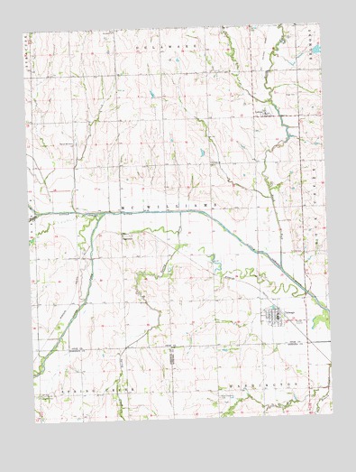
Talmage, NE USGS Topographic Map
Click on map above to begin viewing in our Map Viewer.

This topographic map contains these locations and features:
Feature Name Type Latitude Longitude GNIS ID View Map
Biggs CemeteryCemeteryN40.6025°W96.0108°827439View Map
Cio (historical)Populated PlaceN40.5956°W96.0245°1802618View Map
Delaware ChurchChurchN40.6242°W96.0875°828668View Map
Delaware City Post Office (historical)Post OfficeN40.6244°W96.0836°1884220View Map
Delta (historical)Populated PlaceN40.5956°W96.0245°1802617View Map
Delta Post Office (historical)Post OfficeN40.5956°W96.0245°1802616View Map
East Branch Jones CreekStreamN40.5089°W96.0014°828938View Map
Fairview CemeteryCemeteryN40.5525°W96.0106°829223View Map
Faith Lutheran ChurchChurchN40.5333°W96.0247°1884336View Map
Family Physicians of TalmageHospitalN40.5306°W96.0217°1884334View Map
Farmers Co-op Company ElevatorLocaleN40.5306°W96.0217°1884333View Map
Grant Evergreen CemeteryCemeteryN40.5064°W96.0469°1883779View Map
Grant Post Office (historical)Post OfficeN40.5083°W96.0392°1883780View Map
Little Nemaha River Dam 3-1DamN40.5741°W96.0374°1769760View Map
Little Nemaha River Dam 3-1ADamN40.5717°W96.0303°1769758View Map
Little Nemaha River Dam 3-1BDamN40.5901°W96.0484°1769756View Map
Little Nemaha River Reservoir 3-1ReservoirN40.5753°W96.0396°1769761View Map
Little Nemaha River Reservoir 3-1AReservoirN40.5717°W96.0303°1769759View Map
Little Nemaha River Reservoir 3-1BReservoirN40.5900°W96.0486°1769757View Map
Livingston CemeteryCemeteryN40.5080°W96.1239°830804View Map
LortonPopulated PlaceN40.5956°W96.0245°830895View Map
Lorton (historical)LocaleN40.5975°W96.0211°1884355View Map
Lorton Post OfficePost OfficeN40.5956°W96.0245°1884354View Map
McWilliams Election PrecinctCivilN40.5666°W96.0663°1929058View Map
Muddy CreekStreamN40.5667°W96.1208°831518View Map
N F Little Nemaha Dam 4-14DamN40.6090°W96.0350°1769772View Map
N F Little Nemaha Reservoir 4-14ReservoirN40.6108°W96.0360°1769773View Map
Nemaha Valley SchoolSchoolN40.5300°W96.0253°1884335View Map
North Fork Little Nemaha RiverStreamN40.5469°W96.0195°831694View Map
Saint Johns ChurchChurchN40.5817°W96.0481°832916View Map
South Fork Little Nemaha RiverStreamN40.5664°W96.0931°833590View Map
Spring CreekStreamN40.5658°W96.0614°833692View Map
Spring Creek Dam 2-3DamN40.5176°W96.0715°1767983View Map
Spring Creek Dam 3-1DamN40.5052°W96.0978°1769752View Map
Spring Creek Dam 4-3DamN40.5039°W96.0828°1767975View Map
Spring Creek Reservoir 2-3ReservoirN40.5168°W96.0709°1767984View Map
Spring Creek Reservoir 3-1ReservoirN40.5045°W96.0989°1769753View Map
Spring Creek Reservoir 4-3ReservoirN40.5039°W96.0819°1767976View Map
TalmagePopulated PlaceN40.5306°W96.0217°834026View Map
Talmage (historical)LocaleN40.5339°W96.0211°1884329View Map
Talmage Community Fire DepartmentBuildingN40.5328°W96.0216°1884332View Map
Talmage Nebraska Historical MarkerParkN40.5306°W96.0217°1884295View Map
Talmage Post OfficePost OfficeN40.5320°W96.0222°1884331View Map
Talmage Public LibraryBuildingN40.5306°W96.0217°1884330View Map
Talmage Rescue SquadBuildingN40.5327°W96.0216°2553673View Map
TangemanPopulated PlaceN40.5586°W96.0864°835462View Map
Tangeman (historical)LocaleN40.5586°W96.0864°1884200View Map
Township of McWilliamsCivilN40.5639°W96.0586°1884299View Map
Village of LortonCivilN40.5972°W96.0242°2398477View Map
Village of TalmageCivilN40.5316°W96.0238°2399949View Map
Walnut Hill School (historical)SchoolN40.5892°W96.1058°834455View Map
Wilson Creek Dam 1-FDamN40.6159°W96.0039°1768420View Map
Wilson Creek Dam 3-2DamN40.5846°W96.0506°1768517View Map
Wilson Creek Dam 3-6DamN40.6032°W96.0706°1768447View Map
Wilson Creek Dam 3-CDamN40.5999°W96.0589°1770032View Map
Wilson Creek ReservoirReservoirN40.6008°W96.0606°1770033View Map
Wilson Creek Reservoir 1-FReservoirN40.6166°W96.0016°1768421View Map
Wilson Creek Reservoir 3-2ReservoirN40.5848°W96.0513°1768518View Map
Wilson Creek Reservoir 3-6ReservoirN40.6037°W96.0715°1768448View Map
Zion United Church of GodChurchN40.5319°W96.0247°1884337View Map

Note: Coordinates in the location and feature list above are referenced to NAD83 datum.


Copyright (C) 2008-2024 Ryan Niemi / Sunset Dynamics ... All Rights Reserved