TopoQuest Logo
Do you find TopoQuest useful?
Help keep TopoQuest running and adding new maps/features by donating!
Bitcoin:  19c7KJd3qBynnjoSw5npx9KScwjBe4ifkT
Litecoin:  LXs6TkuXGGXo1vDsWCkWVdjQX94eUKd6ui
Home View Maps Find Maps Find Places Resources & Links


Thomaston, Maine Topographic Map

USGS Map Title: Thomaston, ME
USGS Map MRC: 44069A2
DRG (GeoTIFF) Download: o44069a2.tif


Neighboring USGS Topographic Map Quads:


  Union, ME  
44069B3
 

  West Rockport, ME  
44069B2
 

  Camden, ME  
44069B1
 

  Waldoboro East, ME  
44069A3
 

  Thomaston, ME  
44069A2
 

  Rockland, ME  
44069A1
 

  Friendship, ME  
43069H3
 

  Tenants Harbor, ME  
43069H2
 

  Hewett Island, ME  
43069H1


Map MRC Location:

N45°
W70°
N45°
W69°
H8 H7 H6 H5 H4 H3 H2 H1
G8 G7 G6 G5 G4 G3 G2 G1
F8 F7 F6 F5 F4 F3 F2 F1
E8 E7 E6 E5 E4 E3 E2 E1
D8 D7 D6 D5 D4 D3 D2 D1
C8 C7 C6 C5 C4 C3 C2 C1
B8 B7 B6 B5 B4 B3 B2 B1
A8 A7 A6 A5 A4 A3 A2 A1
N44°
W70°
N44°
W69°

Thomaston, ME USGS 1:24K Topographic Map Preview:
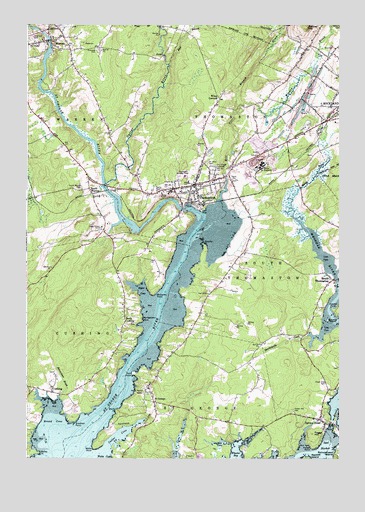
Thomaston, ME USGS Topographic Map
Click on map above to begin viewing in our Map Viewer.

This topographic map contains these locations and features:
Feature Name Type Latitude Longitude GNIS ID View Map
Apostolic Christian Life ChurchChurchN44.0806°W69.1670°1909411View Map
Assembly of God ChurchChurchN44.0781°W69.1745°1909418View Map
Bailey PointCapeN44.0017°W69.2450°561445View Map
Baum BayBayN44.0065°W69.1278°581976View Map
Beaverdam BrookStreamN44.0173°W69.2370°561969View Map
Blank PointCapeN44.0140°W69.2137°562572View Map
Bolduc Correctional FacilityBuildingN44.0677°W69.2177°2735811View Map
Bradford PointCapeN44.0109°W69.2303°562859View Map
Branch BrookStreamN44.0995°W69.1673°562890View Map
Broad CoveBayN44.0106°W69.2387°562992View Map
Combs IslandIslandN44.0401°W69.1298°564256View Map
CushingPopulated PlaceN44.0192°W69.2398°564691View Map
Cushing Community SchoolSchoolN44.0210°W69.2499°580748View Map
Cushing Public LibraryBuildingN44.0209°W69.2500°2738330View Map
Cushing Volunteer Fire StationBuildingN44.0205°W69.2498°2553015View Map
Cutler CoveBayN44.0062°W69.2131°564711View Map
East Branch Oyster RiverStreamN44.1134°W69.1928°565561View Map
Fairview CemeteryCemeteryN44.1178°W69.2214°566003View Map
Federated Church in ThomastonChurchN44.0770°W69.1828°1909457View Map
Foggs HillSummitN44.0074°W69.1364°566355View Map
Forest Hill CemeteryCemeteryN44.0140°W69.1431°566385View Map
Fort PointCapeN44.0245°W69.2070°566424View Map
Fort Saint George (historical)MilitaryN44.0247°W69.2078°1909462View Map
Gilford Butler SchoolSchoolN44.0501°W69.1294°1909476View Map
Grace Bible Fellowship BuildingChurchN44.1015°W69.1359°1909473View Map
Harmony Bible Baptist ChurchChurchN44.0106°W69.1317°1909479View Map
Harrington CoveBayN44.0067°W69.1595°567678View Map
Hayden PointCapeN44.0426°W69.1267°567817View Map
Hospital PointCapeN44.0612°W69.1787°568336View Map
Hyler CoveBayN44.0481°W69.2034°568544View Map
Hyler Jameson CemeteryCemeteryN44.0461°W69.2059°2725222View Map
Kelleran CemeteryCemeteryN44.0250°W69.2388°2725223View Map
Knox BuildingBuildingN44.0734°W69.1795°1909503View Map
Knox County JailBuildingN44.1039°W69.1321°2735963View Map
Knox County Sheriff's OfficeBuildingN44.1038°W69.1321°2735904View Map
Limestone HillSummitN44.0767°W69.1967°1909515View Map
Lura Libby SchoolSchoolN44.0799°W69.1854°1909523View Map
Maine State PrisonBuildingN44.0648°W69.2305°1909527View Map
Maine State Prison LibraryBuildingN44.0646°W69.2306°1909528View Map
Maine Watercraft MuseumBuildingN44.0712°W69.1800°1909529View Map
Marsh BrookStreamN44.0717°W69.1437°570801View Map
McCarthy PointCapeN44.0476°W69.1987°570948View Map
Meadow BrookStreamN44.0995°W69.1673°571073View Map
Mill CoveBayN44.0056°W69.1395°579087View Map
Mill RiverStreamN44.0748°W69.1723°571350View Map
Montgomery PointCapeN44.0398°W69.2037°571524View Map
MontpelierPopulated PlaceN44.0823°W69.1673°1909694View Map
MontpelierBuildingN44.0740°W69.1631°1909543View Map
North CushingPopulated PlaceN44.0390°W69.2106°572325View Map
North Parish CemeteriesCemeteryN44.0201°W69.2028°572376View Map
Ocean View CemeteryCemeteryN44.0219°W69.1298°572666View Map
Oceanside High School WestSchoolN44.0815°W69.1869°1909468View Map
Oyster RiverStreamN44.0792°W69.2178°572904View Map
Patten PointCapeN44.0034°W69.1359°573067View Map
Peoples United Methodist ChurchChurchN44.0509°W69.1273°1909571View Map
Riverview CemeteryCemeteryN44.1211°W69.2482°574266View Map
Saint GeorgePopulated PlaceN44.0165°W69.1989°574711View Map
Saint George Volunteer Fire StationBuildingN44.0116°W69.1740°2552982View Map
Saint James Catholic ChurchChurchN44.0795°W69.1792°1909618View Map
Saint John the Baptist Episcopal ChurchChurchN44.0784°W69.1839°1909619View Map
Saint Johns CemeteryCemeteryN44.0852°W69.1783°574723View Map
Saltwater Farm CampgroundLocaleN44.0556°W69.1956°1909622View Map
Second Congregational ChurchChurchN44.1201°W69.2387°1909630View Map
Sharkeyville CreekStreamN44.0356°W69.1362°575311View Map
South ThomastonPopulated PlaceN44.0515°W69.1278°575911View Map
South Thomaston Ambulance ServiceBuildingN44.0461°W69.1336°2666767View Map
South Thomaston Post OfficePost OfficeN44.0524°W69.1252°1909641View Map
South Thomaston Volunteer Fire DepartmentBuildingN44.0461°W69.1336°2552906View Map
South WarrenPopulated PlaceN44.0756°W69.2228°575921View Map
South Warren CemeteryCemeteryN44.0784°W69.2278°575922View Map
Spruce HeadPopulated PlaceN44.0115°W69.1328°576134View Map
Spruce Head Post OfficePost OfficeN44.0098°W69.1321°1909645View Map
The Village CemeteryCemeteryN44.0834°W69.1753°576940View Map
ThomastonPopulated PlaceN44.0790°W69.1817°576993View Map
Thomaston Ambulance ServiceBuildingN44.0785°W69.1822°2666766View Map
Thomaston Athletic FieldParkN44.0829°W69.1867°576994View Map
Thomaston Baptist ChurchChurchN44.0783°W69.1844°1909653View Map
Thomaston Census Designated PlaceCensusN44.0802°W69.1808°2377961View Map
Thomaston Fire StationBuildingN44.0785°W69.1823°2552689View Map
Thomaston Grammar SchoolSchoolN44.0829°W69.1838°1909654View Map
Thomaston Historic DistrictParkN44.0795°W69.1812°1909655View Map
Thomaston Police DepartmentBuildingN44.0787°W69.1829°2735927View Map
Thomaston Post OfficePost OfficeN44.0793°W69.1820°1909656View Map
Thomaston Public LibraryBuildingN44.0796°W69.1757°1909657View Map
Town of South ThomastonCivilN44.0369°W69.1362°582739View Map
Town of ThomastonCivilN44.0930°W69.1749°582763View Map
WarrenPopulated PlaceN44.1204°W69.2400°577841View Map
Warren Baptist ChurchChurchN44.1206°W69.2353°1909675View Map
Warren Free Public LibraryBuildingN44.1205°W69.2426°1909676View Map
Watts PointCapeN44.0029°W69.2234°577906View Map
WBQX-FM(Thomaston)TowerN44.1081°W69.1572°582090View Map
Willis CornersPopulated PlaceN44.1026°W69.1739°580016View Map

Note: Coordinates in the location and feature list above are referenced to NAD83 datum.


Copyright (C) 2008-2024 Ryan Niemi / Sunset Dynamics ... All Rights Reserved