TopoQuest Logo
Do you find TopoQuest useful?
Help keep TopoQuest running and adding new maps/features by donating!
Bitcoin:  19c7KJd3qBynnjoSw5npx9KScwjBe4ifkT
Litecoin:  LXs6TkuXGGXo1vDsWCkWVdjQX94eUKd6ui
Home View Maps Find Maps Find Places Resources & Links


Tincup, Colorado Topographic Map

USGS Map Title: Tincup, CO
USGS Map MRC: 38106G4
DRG (GeoTIFF) Download: o38106g4.tif


Neighboring USGS Topographic Map Quads:


  Pieplant, CO  
38106H5
 

  Winfield, CO  
38106H4
 

  Mount Harvard, CO  
38106H3
 

  Taylor Park Reservoir, CO  
38106G5
 

  Tincup, CO  
38106G4
 

  Mount Yale, CO  
38106G3
 

  Fairview Peak, CO  
38106F5
 

  Cumberland Pass, CO  
38106F4
 

  Saint Elmo, CO  
38106F3


Map MRC Location:

N39°
W107°
N39°
W106°
H8 H7 H6 H5 H4 H3 H2 H1
G8 G7 G6 G5 G4 G3 G2 G1
F8 F7 F6 F5 F4 F3 F2 F1
E8 E7 E6 E5 E4 E3 E2 E1
D8 D7 D6 D5 D4 D3 D2 D1
C8 C7 C6 C5 C4 C3 C2 C1
B8 B7 B6 B5 B4 B3 B2 B1
A8 A7 A6 A5 A4 A3 A2 A1
N38°
W107°
N38°
W106°

Tincup, CO USGS 1:24K Topographic Map Preview:
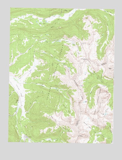
Tincup, CO USGS Topographic Map
Click on map above to begin viewing in our Map Viewer.

This topographic map contains these locations and features:
Feature Name Type Latitude Longitude GNIS ID View Map
AbbeyvillePopulated PlaceN38.7775°W106.4922°189092View Map
Bertha GulchValleyN38.7783°W106.4905°188923View Map
Cottonwood PassGapN38.8278°W106.4092°189140View Map
Cow LakeLakeN38.8198°W106.4285°189095View Map
East Willow CreekStreamN38.7539°W106.4820°189116View Map
Garden BasinBasinN38.7617°W106.4270°189090View Map
Garden MineMineN38.7642°W106.4309°189091View Map
Grassy GulchValleyN38.7573°W106.3759°189132View Map
Halfway StationLocaleN38.8106°W106.3895°189138View Map
Iron Ore Lode MineMineN38.7689°W106.4970°1745677View Map
Jones MountainSummitN38.7728°W106.3945°189135View Map
Kentucky GulchValleyN38.7980°W106.4930°189142View Map
Lost LakeLakeN38.8036°W106.4149°189137View Map
Middle Willow CreekStreamN38.7539°W106.4820°189117View Map
Mineral BasinBasinN38.7606°W106.3992°189134View Map
Mineral CreekStreamN38.7586°W106.3928°189216View Map
Mount KreutzerSummitN38.7611°W106.4172°189133View Map
North Fork Middle Cottonwood CreekStreamN38.8033°W106.3900°189214View Map
Osbourne CreekStreamN38.8089°W106.3917°189139View Map
Prospector GulchValleyN38.8691°W106.4396°189098View Map
Ptarmigan LakeLakeN38.7773°W106.3845°189130View Map
Sanford BasinBasinN38.7889°W106.4278°189094View Map
Sanford CreekStreamN38.8108°W106.4984°189093View Map
Sawatch RangeRangeN38.8211°W106.3900°203385View Map
South Texas CreekStreamN38.8722°W106.3853°189111View Map
Spout LakeLakeN38.7883°W106.4101°189136View Map
Texas LakesLakeN38.8622°W106.4615°189099View Map
TincupPopulated PlaceN38.7544°W106.4784°189089View Map
Turner PeakSummitN38.8197°W106.3789°196539View Map
Wander RidgeRidgeN38.8091°W106.4225°2790779View Map
West Willow CreekStreamN38.7550°W106.4834°189221View Map

Note: Coordinates in the location and feature list above are referenced to NAD83 datum.


Copyright (C) 2008-2025 Ryan Niemi / Sunset Dynamics ... All Rights Reserved