TopoQuest Logo
Do you find TopoQuest useful?
Help keep TopoQuest running and adding new maps/features by donating!
Bitcoin:  19c7KJd3qBynnjoSw5npx9KScwjBe4ifkT
Litecoin:  LXs6TkuXGGXo1vDsWCkWVdjQX94eUKd6ui
Home View Maps Find Maps Find Places Resources & Links


Cape Vincent North, New York Topographic Map

USGS Map Title: Cape Vincent North, NY
USGS Map MRC: 44076B3
DRG (GeoTIFF) Download: o44076b3.tif


Neighboring USGS Topographic Map Quads:


  Gananoque, ON  
44076C2


  Cape Vincent North, NY  
44076B3
 

  Saint Lawrence, NY  
44076B2


  Cape Vincent South, NY  
44076A3
 

  Chaumont, NY  
44076A2


Map MRC Location:

N45°
W77°
N45°
W76°
H8 H7 H6 H5 H4 H3 H2 H1
G8 G7 G6 G5 G4 G3 G2 G1
F8 F7 F6 F5 F4 F3 F2 F1
E8 E7 E6 E5 E4 E3 E2 E1
D8 D7 D6 D5 D4 D3 D2 D1
C8 C7 C6 C5 C4 C3 C2 C1
B8 B7 B6 B5 B4 B3 B2 B1
A8 A7 A6 A5 A4 A3 A2 A1
N44°
W77°
N44°
W76°

Cape Vincent North, NY USGS 1:24K Topographic Map Preview:
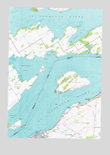
Cape Vincent North, NY USGS Topographic Map
Click on map above to begin viewing in our Map Viewer.

This topographic map contains these locations and features:
Feature Name Type Latitude Longitude GNIS ID View Map
Anchor MarinaLocaleN44.1306°W76.3288°973743View Map
Burnham Point State ParkParkN44.1623°W76.2641°945231View Map
Cape VincentPopulated PlaceN44.1278°W76.3330°945801View Map
Cape Vincent Central SchoolSchoolN44.1258°W76.3311°2416810View Map
Cape Vincent Community LibraryBuildingN44.1264°W76.3367°2416801View Map
Cape Vincent Fire DepartmentBuildingN44.1283°W76.3357°2416803View Map
Cape Vincent Police DepartmentBuildingN44.1295°W76.3355°2780362View Map
Cape Vincent Water Works Pumping StationBuildingN44.1278°W76.3397°2416812View Map
Carleton IslandIslandN44.1834°W76.2913°945837View Map
Carleton LighthouseBuildingN44.1806°W76.3097°2097010View Map
Feather Bed ShoalBarN44.1584°W76.3066°973323View Map
First Methodist ChurchChurchN44.1283°W76.3333°2416809View Map
First Presbyterian ChurchChurchN44.1278°W76.3350°2416802View Map
Grass BayBayN44.1595°W76.2779°951535View Map
Green Cedars Trailer ParkPopulated PlaceN44.1674°W76.2541°2618229View Map
Hinckley Flats ShoalBarN44.1559°W76.3402°973632View Map
Judd CemeteryCemeteryN44.1493°W76.2963°954213View Map
Lawrence J Docteur DockLocaleN44.1495°W76.2986°973769View Map
Le Petite Ciel Mobile Home ParkPopulated PlaceN44.1446°W76.3041°2618251View Map
Leading LightLocaleN44.1692°W76.3111°973741View Map
North BayBayN44.1703°W76.3101°958674View Map
Peos BayBayN44.1690°W76.2504°960167View Map
Poplar Tree BayBayN44.1548°W76.2922°960945View Map
Riverside CemeteryCemeteryN44.1376°W76.3095°962588View Map
Roxy IslandsIslandN44.1564°W76.3113°963059View Map
Saint Vincent de Paul CemeteryCemeteryN44.1339°W76.3149°964260View Map
School Number 13 (historical)SchoolN44.1386°W76.3089°2097012View Map
School Number 5 (historical)SchoolN44.1333°W76.2769°2097011View Map
Scotch BrookStreamN44.1362°W76.3124°964661View Map
South BayBayN44.1690°W76.3048°965671View Map
SunnybankPopulated PlaceN44.1656°W76.2535°973744View Map
Sunset Trailer ParkPopulated PlaceN44.1472°W76.3016°2618292View Map
United Church of Cape VincentChurchN44.1278°W76.3350°2617118View Map
Village of Cape VincentCivilN44.1263°W76.3302°2391581View Map
Willow Shores MarinaLocaleN44.1503°W76.2974°973745View Map

Note: Coordinates in the location and feature list above are referenced to NAD83 datum.


Copyright (C) 2008-2025 Ryan Niemi / Sunset Dynamics ... All Rights Reserved