TopoQuest Logo
Do you find TopoQuest useful?
Help keep TopoQuest running and adding new maps/features by donating!
Bitcoin:  19c7KJd3qBynnjoSw5npx9KScwjBe4ifkT
Litecoin:  LXs6TkuXGGXo1vDsWCkWVdjQX94eUKd6ui
Home View Maps Find Maps Find Places Resources & Links


Antonito, Colorado Topographic Map

USGS Map Title: Antonito, CO
USGS Map MRC: 37106A1
DRG (GeoTIFF) Download: o37106a1.tif


Neighboring USGS Topographic Map Quads:


  Vicente Canyon, CO  
37106B2
 

  Goshawk Dam, CO  
37106B1
 

  Manassa, CO  
37105B8
 

  Fox Creek, CO  
37106A2
 

  Antonito, CO  
37106A1
 

  Lobatos, CO  
37105A8
 

  Bighorn Peak, NM  
36106H2
 

  Los Pinos, NM  
36106H1
 

  Pinabetoso Peaks, NM  
36105H8


Map MRC Location:

N38°
W107°
N38°
W106°
H8 H7 H6 H5 H4 H3 H2 H1
G8 G7 G6 G5 G4 G3 G2 G1
F8 F7 F6 F5 F4 F3 F2 F1
E8 E7 E6 E5 E4 E3 E2 E1
D8 D7 D6 D5 D4 D3 D2 D1
C8 C7 C6 C5 C4 C3 C2 C1
B8 B7 B6 B5 B4 B3 B2 B1
A8 A7 A6 A5 A4 A3 A2 A1
N37°
W107°
N37°
W106°

Antonito, CO USGS 1:24K Topographic Map Preview:
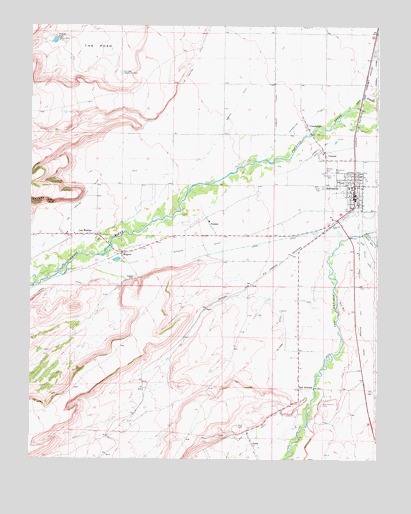
Antonito, CO USGS Topographic Map
Click on map above to begin viewing in our Map Viewer.

This topographic map contains these locations and features:
Feature Name Type Latitude Longitude GNIS ID View Map
AntonitoPopulated PlaceN37.0792°W106.0086°190909View Map
Antonito CemeteryCemeteryN37.0821°W106.0158°190910View Map
Antonito Police DepartmentBuildingN37.0746°W106.0090°2696622View Map
Antonito Post OfficePost OfficeN37.0758°W106.0086°2750907View Map
Assembly of God Cristo El ReyChurchN37.0820°W106.0079°2696359View Map
Bulldog Detention DamDamN37.1120°W106.0928°190916View Map
Caņon DitchCanalN37.0583°W106.0645°203500View Map
ConejosPopulated PlaceN37.0883°W106.0197°190913View Map
Conejos CemeteryCemeteryN37.0838°W106.0182°190911View Map
Conejos Census Designated PlaceCensusN37.0873°W106.0160°2631317View Map
Conejos County Sheriff's OfficeBuildingN37.0860°W106.0054°2696616View Map
Conejos Post OfficePost OfficeN37.0895°W106.0201°2750905View Map
El Coda DitchCanalN37.0333°W106.0339°190921View Map
GuadalupePopulated PlaceN37.0953°W106.0256°190914View Map
Guadalupe DitchCanalN37.1000°W106.0228°190915View Map
Guadalupe Elementary SchoolSchoolN37.0786°W106.0103°2035924View Map
Las MesitasPopulated PlaceN37.0645°W106.1106°190924View Map
Las Mesitas DitchCanalN37.0945°W106.0900°203496View Map
Llano DitchCanalN37.0083°W106.0450°203507View Map
MogotePopulated PlaceN37.0595°W106.0922°190923View Map
Mogote CemeteryCemeteryN37.0522°W106.0875°190922View Map
Mogote DitchCanalN37.1000°W106.0528°203495View Map
OrtizPopulated PlaceN37.0042°W106.0442°203508View Map
Ortiz CemeteryCemeteryN37.0096°W106.0502°190918View Map
PaisajePopulated PlaceN37.0678°W106.0606°204766View Map
Riprap DamDamN37.1211°W106.1161°190917View Map
San AntonioPopulated PlaceN37.0208°W106.0281°190920View Map
San Antonio CemeteryCemeteryN37.0161°W106.0200°190919View Map
South Conejos Fire Protection District and Emergency Medical Services 1 Antonito Fire DepartmentBuildingN37.0688°W106.0165°2667017View Map
The PosoBasinN37.1189°W106.1020°203497View Map
Town of AntonitoCivilN37.0766°W106.0102°2412370View Map
Warshaver CemeteryCemeteryN37.0828°W106.0159°190912View Map

Note: Coordinates in the location and feature list above are referenced to NAD83 datum.


Copyright (C) 2008-2025 Ryan Niemi / Sunset Dynamics ... All Rights Reserved