TopoQuest Logo
Do you find TopoQuest useful?
Help keep TopoQuest running and adding new maps/features by donating!
Bitcoin:  19c7KJd3qBynnjoSw5npx9KScwjBe4ifkT
Litecoin:  LXs6TkuXGGXo1vDsWCkWVdjQX94eUKd6ui
Home View Maps Find Maps Find Places Resources & Links


Golden, New Mexico Topographic Map

USGS Map Title: Golden, NM
USGS Map MRC: 35106C2
DRG (GeoTIFF) Download: o35106c2.tif


Neighboring USGS Topographic Map Quads:


  San Felipe Pueblo NE, NM  
35106D3
 

  Madrid, NM  
35106D2
 

  Picture Rock, NM  
35106D1
 

  Hagan, NM  
35106C3
 

  Golden, NM  
35106C2
 

  Captain Davis Mountain, NM  
35106C1
 

  Sandia Park, NM  
35106B3
 

  San Pedro, NM  
35106B2
 

  King Draw, NM  
35106B1


Map MRC Location:

N36°
W107°
N36°
W106°
H8 H7 H6 H5 H4 H3 H2 H1
G8 G7 G6 G5 G4 G3 G2 G1
F8 F7 F6 F5 F4 F3 F2 F1
E8 E7 E6 E5 E4 E3 E2 E1
D8 D7 D6 D5 D4 D3 D2 D1
C8 C7 C6 C5 C4 C3 C2 C1
B8 B7 B6 B5 B4 B3 B2 B1
A8 A7 A6 A5 A4 A3 A2 A1
N35°
W107°
N35°
W106°

Golden, NM USGS 1:24K Topographic Map Preview:
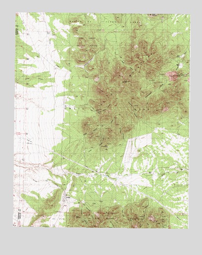
Golden, NM USGS Topographic Map
Click on map above to begin viewing in our Map Viewer.

This topographic map contains these locations and features:
Feature Name Type Latitude Longitude GNIS ID View Map
Birds EyeMineN35.2553°W106.1745°918011View Map
Boxcar CampLocaleN35.3634°W106.2275°886685View Map
Buckeye CanyonValleyN35.3012°W106.1711°886836View Map
Caņon de PerryValleyN35.2684°W106.1536°897772View Map
Caņon del AguaCivilN35.2528°W106.2195°902800View Map
Caņon Monte del LargoValleyN35.3039°W106.2000°897829View Map
Carache CanyonValleyN35.3067°W106.1636°887190View Map
CD-1 Water WellWellN35.3417°W106.1403°922935View Map
Cedar MountainSummitN35.3745°W106.1536°887344View Map
Cerro ColumboSummitN35.2559°W106.2061°897890View Map
Cunningham GulchValleyN35.3403°W106.1267°888156View Map
Cunningham HillSummitN35.3400°W106.1339°898754View Map
Deer SpringSpringN35.3506°W106.1334°888303View Map
Dolores Gulch Water WellWellN35.3423°W106.1395°922936View Map
Dolores RanchLocaleN35.3450°W106.1322°888444View Map
Eagle CanyonValleyN35.3514°W106.1772°888609View Map
El PuntoSummitN35.3098°W106.1992°888823View Map
Glenn RanchLocaleN35.2828°W106.1520°889429View Map
GoldenPopulated PlaceN35.2670°W106.2139°915830View Map
Golden Census Designated PlaceCensusN35.2637°W106.2230°2584105View Map
Golden PlacerMineN35.2650°W106.2020°917134View Map
Golden Post Office (historical)Post OfficeN35.2670°W106.2139°938080View Map
Golden Weather StationLocaleN35.2670°W106.2139°932582View Map
Gypsy Queen CanyonValleyN35.3212°W106.1970°889675View Map
Gypsy Queen MineMineN35.3178°W106.1922°889676View Map
Iron PrincessMineN35.2517°W106.1603°917125View Map
JamisonMineN35.2534°W106.1664°917126View Map
JessieMineN35.2573°W106.1597°917127View Map
JICMineN35.2556°W106.1442°917128View Map
Las Lomas de la BolsaAreaN35.3573°W106.1972°890954View Map
Lone Mountain Cattle CompanyLocaleN35.2839°W106.1509°930463View Map
Lukas CanyonValleyN35.2912°W106.2003°891490View Map
Mine del CandelarioMineN35.2973°W106.1842°892089View Map
New MexicoMineN35.2525°W106.2036°917122View Map
New YearsMineN35.2537°W106.2050°917123View Map
Ninety-Nine MineMineN35.2550°W106.1975°939996View Map
Old LS NOR Water WellWellN35.3489°W106.1317°925892View Map
Old TimerMineN35.2539°W106.1947°917124View Map
Oldtimer CanyonValleyN35.2778°W106.2056°892908View Map
OR-3 Water WellWellN35.3398°W106.1295°922934View Map
Ortiz (historical)Populated PlaceN35.3362°W106.1517°914398View Map
Ortiz MineMineN35.3362°W106.1517°892944View Map
Ortiz MineMineN35.3389°W106.1381°896863View Map
Ortiz Mine GrantCivilN35.3431°W106.1506°915874View Map
Ortiz MountainsRangeN35.3428°W106.1611°928764View Map
Pine Tree CanyonValleyN35.2628°W106.1720°893288View Map
Placer MountainSummitN35.3356°W106.1700°918290View Map
Saint Luke MineMineN35.2553°W106.1975°917117View Map
Saint Paul MineMineN35.2567°W106.1975°917118View Map
San Francisco CanyonValleyN35.2659°W106.2028°894415View Map
San Francisco Catholic Church CemeteryCemeteryN35.2678°W106.2136°931313View Map
San Franciso ChurchChurchN35.2695°W106.2136°894418View Map
San PedroMineN35.2523°W106.1986°916461View Map
San Pedro PassGapN35.2828°W106.1520°902795View Map
Shamrock MineMineN35.2556°W106.1881°917116View Map
Stagecoach CanyonValleyN35.3434°W106.2031°895291View Map
SunnysideMineN35.2520°W106.1870°917119View Map
SunsetMineN35.2520°W106.1850°917120View Map
TennesseeMineN35.2578°W106.1722°918013View Map
Triangle LodeMineN35.2550°W106.1975°918014View Map
Tuerto SpringSpringN35.2812°W106.2159°895886View Map

Note: Coordinates in the location and feature list above are referenced to NAD83 datum.


Copyright (C) 2008-2024 Ryan Niemi / Sunset Dynamics ... All Rights Reserved